
Introduction
Urban Planning
In the post-pandemic reality, a vision for urbanism is necessarily situated in the critical issues of our time: climate change, social and racial justice, and emerging technologies. While their scale is global, students in the Urban Planning Program connect these issues with the local and regional contexts through grounded analysis of socioeconomic and political conditions. Our program prepares students to confront and break down structures and practices of oppression rooted in inequality, racism, and sexism. It also fosters creative and critical approaches to planning and policy that improve processes and outcomes in cities around the world. The work completed this academic year shows how Urban Planning students embrace professional challenges and responsibilities with sensitivity and courage.
Studios
Spring 2022
Converted Homes: From Offices to Affordable Homes
The COVID-19 pandemic exacerbated New York City’s affordable housing crisis and ravaged the commercial office real estate market, forcing us to rethink our dependence on office space. With the normalization of hybrid and work-from-home models, New York City has record high office vacancy rates, and the commercial real estate market will likely never recover to pre-pandemic levels. For our studio, we were tasked with finding solutions at the junction of both of these major problems through commercial-to-residential conversions. Furthermore, we were charged with exploring the potential of conversion to meet housing needs in New York City, studying the physical, financial, regulatory, and political barriers, and proposing policy changes needed to facilitate office and hotel conversion to affordable housing.
Our studio partnered with the Citizens Housing and Planning Council, a leading research and advocacy organization focused on housing and planning issues in New York City. Founded in 1937, its mission is to develop and advance practical public policies that support the city’s housing stock and has been one of the many stakeholders involved in advancing opportunities for legislative actions for office and hotel conversion to affordable housing. CHPC acknowledges that while many current conversations have been centered around the feasibility and regulatory barriers to conversion, certain key questions on the potential of conversion still remain unanswered.
Through rigorous research into the legislative landscape of New York City housing conversion policies, affordable housing programs, and architectural practices, we sought out to address barriers to efficient office-to-hotel conversions. In addition, using spatial data analysis, we honed in on three New York City office buildings of various different typologies in Midtown, the Financial District, and Forest Hills, Queens to demonstrate the diversity of potential conversion models.
TA: Jonathan Marty
Students: Zhihao Bao, Christian Budow, Kimberly Cheung, Kit Nga Chou, Stacey Chui, Carlos Miranda
Pereyra, Wenqi (Hazel) Ni, Alisa Nurmansyah, Morgan Reuther, Daniel Wexler, Andrea Wong Magnalardo
Client: Citizen’s Housing and Planning Council


Spring 2022
Reimagining Public Space in Pandemic & Post-Pandemic New York
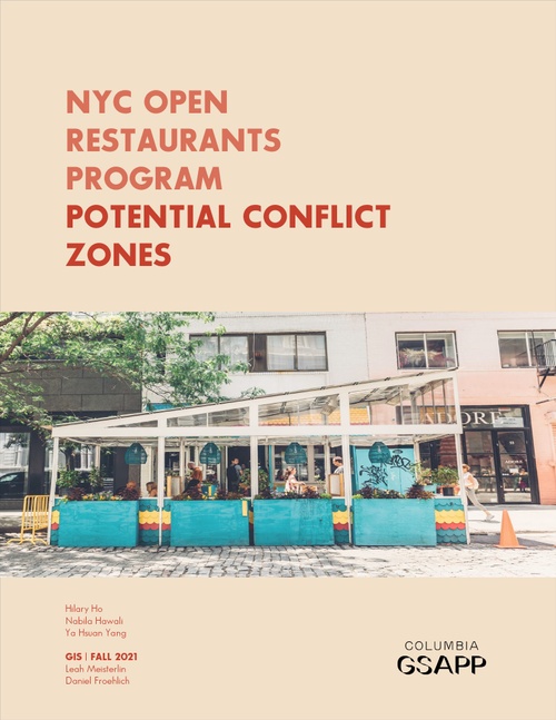
At the height of the COVID-19 pandemic, New York City’s streets, sidewalks, and plazas which are normally crowded and teeming with life, were empty and lifeless. The pandemic was anti-urban. It preyed on our desire to be together, prompting many to speculate that the pandemic was the end of cities. Despite this bleak outlook, something beautiful happened. From formal interventions like NYC Open Streets and Open Restaurants, to informal, bottom-up, changes in the use of public space, the pandemic opened the door for dramatic and creative reevaluations of what and who public space is for and how it can be used.
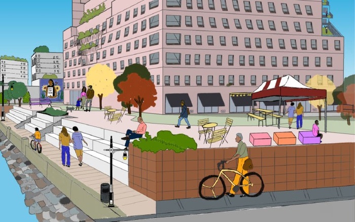
The studio aimed to reimagine what equitable public spaces could be in a post-pandemic world and sought to build upon the work done with the temporary Open Streets and Open Restaurants programs as they transition towards permanence. The studio ultimately arrived at strategies and interventions to ensure public space equity that focused on creating new and flexible typologies called CoScapes, supported by a place governance management framework and adequate financial resources. The studio was guided by the belief that everyone regardless of zip code can and should have access to open space and these spaces should be managed with openness, transparency, and community input.
TA: Sarah Mawdsley
Students: Tomas Carrillo, Hilary Ho, HaoChe Hung, Candice (Siyun) Ji, Jim Lammers, Fukunda Mbaru, Jillian
Solomon, Kevin Tang, Varisa Tantiwasadakran, Sofia Vala, Mia Winther-Tamaki, Ya Hsuan Yang
Client: NYC Department of Transportation


To get feedback from users of public space, we conducted 2 community engagement events in collaboration with 2 Open Streets partners, 34th Ave in Queens and Vanderbilt Ave in Brooklyn.
One of our community engagement event activities was this board where participants could provide ideas for Open Streets in green post-its and areas for improvement in pink post-its.
CoScapes is our studio’s vision for community-centered streetscapes that promote adaptable, socially resilient, and equitable public spaces in NYC.
The four factors affecting what type of CoScape street elements a neighborhood might pursue include neighborhood demographics, built environment context, seasonality, and programming capacity.
By implementing a concessions system on the Open Restaurants fee, outdoor dining structures can be activated to serve multipurpose uses for the public.
Factors such as location, structural features, business characteristics, and concessions are features that can go into a new system to equitably charge Open Restaurants.
The CoScapes Bridge Fund allows CoScapes organizers to receive short-term funding for the gap between the payment of programming expenses and the arrival of reimbursement-based grant funds.
To facilitate a place governance CoScapes management structure, we propose an online platform tool to assist the creation of bottom-up, community-centered CoScapes.
A main part of our community workshops was getting the chance to speak with users of public space. We conducted video interviews to give people who wanted to share their longterm ideas for their spaces a platform to do so.
A main part of our community workshops was getting the chance to speak with users of public space. We conducted video interviews to give people who wanted to share their longterm ideas for their spaces a platform to do so.
Spring 2022
Planning for Migrant Shelter | Case Study: Newark
This studio focused on the City of Newark, New Jersey as a case study. Newark is the third oldest city in the United States, New Jersey’s most diverse and populous city, and a first stop for generations of migrants, from Italians to the Great Migration from the South, to Irish, Portuguese, Brazilians and many more nationalities. A study released by the bipartisan research and advocacy thinktank New American Economy ranked New Jersey first in its ability to integrate immigrant communities into the “fabric of American life.” With a 2020 population of over 300,000 and a progressive mayoral administration, Newark is one of the nation’s major air and rail hubs with excellent transit access the economic behemoth next door, New York City.
The goal was to develop a climate change sensitive planning model for housing migrant populations. Course readings focused on developing a basic understanding of local planning approaches as well as understanding the migrants and their needs. The studio surveyed current thinking on the housing of migrant populations and examined local land use and zoning laws and ordinances that either supported or were a hindrance to achieving a good outcome. The client is the Newark, New Jersey Office of Planning & Zoning.
TA: Maureen Abi Ghanem
Students: Kirthi Balakrishnan, Ariana Bon-Hodoyán, Michelle Chen, Rozette De Castro, Zhaoxuan Duan, Calvin Harrison, Nabila Hawali, Lizzie Lee, Victoria Lin, Geryel Osorio Godoy, Robert Sanchez
Client: City of Newark


Spring 2022
Retreat or Resurgence: Reimagining Planning for Climate Change in New York City
The Retreat or Resurgence studio explored the role community-centered actors and strategies can play in planning for climate adaptation in low-lying areas across New York City. It focused in neighborhoods where repeated flooding is expected to result in a change in the occupancy and ownership of property, potentially create vacancy, and a need for new land uses. This studio aimed to reimagine both the role of existing actors and land management strategies, such as community land trusts and land-banking, in communities experiencing these transitions.
The studio partnered with the NYC Mayor’s Office of Environmental and Climate Justice (MOCEJ) and The Nature Conservancy to design a research strategy and project objectives.
The studio produced a method for climate adaptation planning in NYC. Using neighborhood case studies as a basis, the studio created a typology matrix to evaluate scenarios of how neighborhoods may experience transitions. Ultimately it identified the viable pathways for transformative climate adaptation in these neighborhood types.
The studio’s findings mark a significant contribution to the city’s understanding of climate adaptation and will be integrated into MOCEJ and the Nature Conservancy’s What Happens to the Land after Residential Buyouts report.
TA: David McNamara
Students: Sarah Abdallah, Natalie Bartfay, Sean Chew, Margaret Hanson, Dmitri Johnson, Ted Leventhal, Mollye Liu, Nikolas Michael, Sabina Sethi Unni, Matthew Shore, Eshwatti Sookram, Kyliel Thompson
Client: NYC Mayor’s Office


Spring 2022
After the Empire: Reimagining Stranded Assets in the Hudson Valley
The studio studied the impact of abandoned or underutilized public infrastructures to propose policies, programs, and designs that reconcile them with the landscape, natural systems, and local communities. The focus of our studio is the Hudson Valley, a region that experienced rapid growth during the Industrial Revolution followed by decline due to the advent of new technologies,resulting in abandoned infrastructure throughout the region. Students explored different types of “stranded assets” which are public and private infrastructure with communal and environmental value that have been or will become abandoned due to political, economic, environmental, and technological change. They explored how these infrastructures can be rebuilt in innovative ways to address environmental and equity goals and address issues that led to or were caused by their stranding. The studio looked at interventions in the territory—including infrastructures, extraction quarries, landfills, etc.—that have altered its environmental and socio-economic dynamics, analyzing them in terms of their impacts and opportunities. These were understood as assets to promote the ecological regeneration of the region as well as to address the socio-economic and environmental challenges of surrounding communities. The studio’s final proposals promoted new and more holistic ways to connect mankind to nature and to imagine new ways to live under contemporary planetary challenges.
Students: Zina Berrada, Sebastian Bielski, Jidong Cai, Gabrielle Coleman, Eliza Dekker, Ruonan Du, Isaac Hadi Khouzam, Thiago Lee, Charlie Liu, Polina Stepanova, Wei Xiao, Ruiqi Zhu
Client: Groundwork Hudson Valley


Courses
Spring 2022
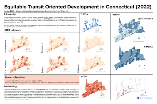
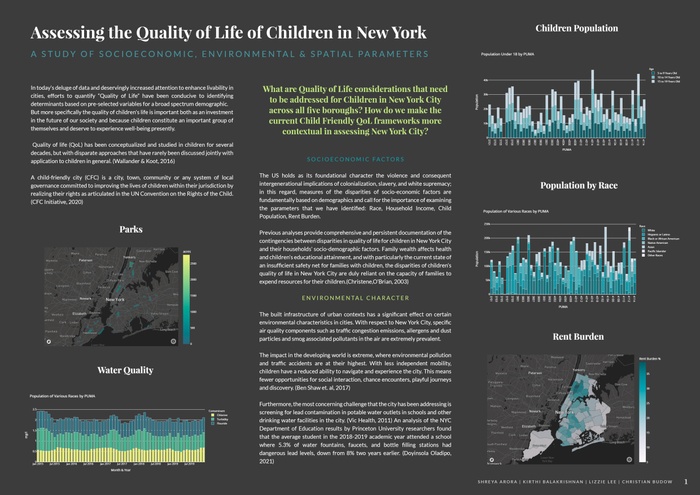
Advanced Spatial Analysis
This advanced seminar examined and developed techniques of spatial analysis and representation specific to urban contexts. The course centered around key methodologies including advanced spatial statistics, spatial decision support systems, feature recognition, and interpolation, interrogating their use and applicability to different contexts in research and practice. Through case studies, students learned several new methods, comparing distinct approaches to similar questions and considering the implications—ethical and otherwise—of spatial analysis and cartography.
Students: Shreya Arora, Eliza Dekker, Jackson Fordham, Sori Han, Calvin Harrison, Nikolas Michael, Carlos Miranda Pereyra, Danielle Roberts, Varisa Tantiwasadakran, Sabina Unni, Daniel Wexler, Shen Xin, Zhaoxiang Yun
Fall 2021
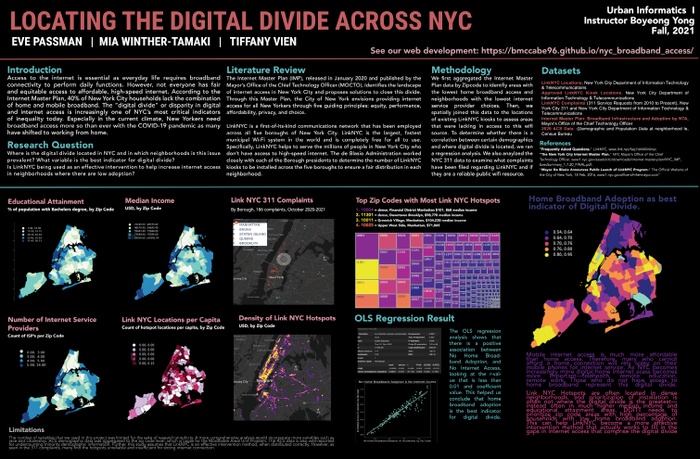
Urban Analytics and Human-Centered Decision Making
This practical and multidisciplinary course helped students learn the skills and knowledge required to work with organizations in making urban innovation decisions involving technology. With a focus on institutions, data analytics, and decision-making tools and with the support of case studies, lectures, and guest speakers, students worked in teams with a real organization throughout the semester. Divided into two groups working on different projects, the teams identified and addressed a critical issue their client faces regarding its urban innovation efforts. Locally, the project consisted of a smarter city plan for the Bronx, NYC, in partnership with The Bronx Community Foundation. Globally, the project focused on artificial intelligence and smarter digital government in Brazil, in partnership with ITS-Rio.
Students: Zaynab Abdi, Tamim Abedin, Sameea Butt, Jidong Cai, Boyang Dan, Jianwen Du, Jackson Fordham, Sori Han, Siyun Ji, Dmitri Johnson, Justin Kits, Lizzie Lee, Aria Ling, Gadha Raj Nadupparambil, Eve Passman, Sreenidhi Rao, Danielle Roberts, Sebastian Salas, Katherin Sibel, Jiabao Sun, Kevin Tang, Mia Winther-Tamaki, Shen Xin


This project represents a concerted three-month long effort to equip Rio de Janeiro’s government with the practical technological tools to foster a culture of transparency in their government. Through interviews with key stakeholders, robust analysis of Rio’s cultural context, and case study review, the Rio team developed an expertise in human-centered technology, and artfully deployed it to develop an interoperable product for the municipality. With the dashboard prototype designed by the Columbia student team, Rio can seamlessly deploy a platform to simplify data collection for agency-wide information sharing process. The dashboard provides interactive incentivization and transparency tools to foster better agency-wide decision making. Not only have we provided the platform, but we have outlined a detailed implementation strategy and designed a user guide to ensure that Rio can deploy this product with minimal friction.
The New York City Mayor’s Office of the Chief Technology Officer (MOCTO) worked in close partnership with Columbia University, Graduate School of Architecture, Planning and Preservation (GSAPP) instructor, André Corrêa d’Almeida, and challenged students to grapple with the demands to quantify workforce needs in the Internet of Things (IoT) ecosystem in New York City. This report provides the methodologies and findings as a result of the almost three-month process, during which the team members explored the information about the state of the IoT workforce, needs of employers, and any skills gaps that exist in order for MOCTO to move forward with implementing a dashboard that tracks existing and emerging IoT-related skills needs.
Fall 2021
Practicum: Reimagining Public Space
Through fieldwork in New York, the practicum “Reimagining Public Space in Pandemic and Post-Pandemic New York” gave students the opportunity to document, categorize, map, analyze, and evaluate changes to the city’s landscape. The temporary and ad-hoc urban forms produced by the pandemic embody both precarity and opportunity. In addition to documentation, this practicum, therefore, asked students to think critically and creatively about how these short-term interventions might inform longer-term shifts in the ways planners conceptualize and plan for public space. Can the new urban forms of the pandemic city play a part in building a more inclusive and just post-pandemic public realm? How can humans move from crisis and uncertainty towards an enduring vision for a more dynamic, equitable, and healthy city?
Students: Shreya Arora, Kit Nga Chou, Leila Collins, Mark-Henry Decrausaz, Jackson Fordham, Sori Han, HaoChe Hung, Nile Johnson, Soyeon Kim, Jonathan Marty, Sarah Mawdsley, Mauricio Rada Orellana, Danielle Roberts, Matthew Shore, Varisa Tantiwasadakran, Tiffany Vien, Andrea Wong Magnalardo, Shen Xin, Zhaoxiang Yun


Spring 2022
Urban Informality
In cities of the Global South and Global North, informal practices play an important role in the urbanization processes and the structuring of urban space, social life, and economic activity. In this course, students learned about the informal city through reviewing the history of informality in the social sciences, analyzing various examples of informal practices, and critically evaluating past attempts by cities to address informality. The class also delved into theoretical questions about informality. By the end of this course, students gained a deeper understanding of the multiple dimensions of the phenomenon of urban informality and the many debates surrounding the issue. They learned to plan and design with and for the informal city, with an eye towards equity and social justice.
Spring 2022
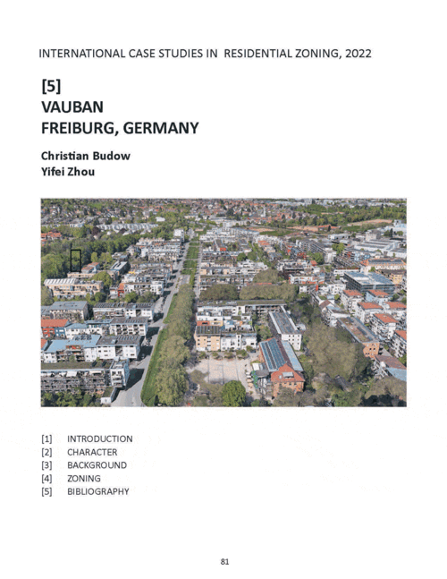
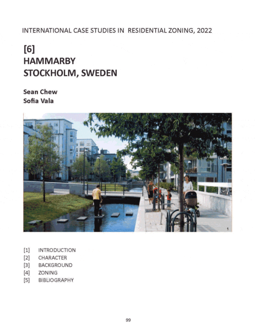
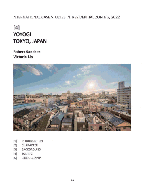
Practicum: Residential Planning in Global Cities
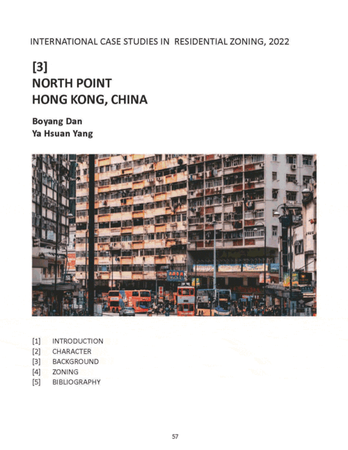
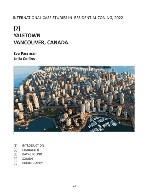
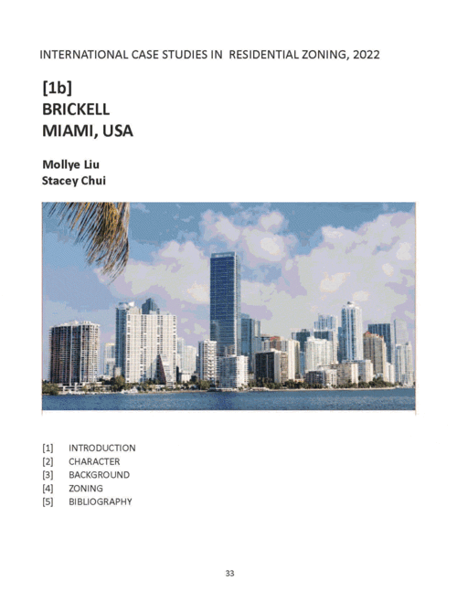
As the world’s urban population grows towards six and a half billion by 2050, cities all over the world are resorting to the mass-production of residential super-blocks to address new urban housing demands. But is this model appropriate for all cities regardless of their environmental, social, political, and economic differences? This seminar provided students with the opportunity to understand how planning regulations —specifically residential codes—shape the design and functioning of urban neighborhoods. Students worked in teams to develop zoning case studies of distinctive residential districts selected from global cities such as Hong Kong, Singapore, Tokyo, Amsterdam, Barcelona, Vancouver, New York, Rio De Janeiro, and Bogota and explored ideas about how regulatory codes can address the challenges that come with unprecedented urban expansion.
Spring 2022
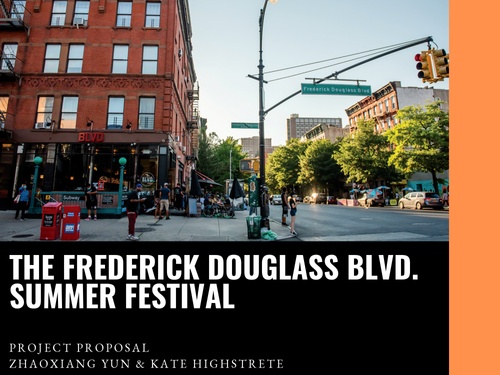
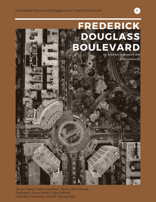
Community Outreach & Engagement: A Harlem Practicum
This course enabled students to actively participate in the community engagement and New York City development process, guided by a set of lectures, readings, baseline plans, and a case study as well as the experiences of knowledgeable practitioners. In teams, students undertook a semester-long exchange with stakeholders around a pivotal planning and development process in Harlem: The Frederick Douglass Boulevard Initiative. They learned standard techniques of engagement; how to determine who represents a given community; how to guide a planning process through the New York City development process; to conduct public engagement and presentations; and the use of oral, graphic, written, and social media tools and approaches to cope with racial, ethnic and class sensitivities.
Fall 2021
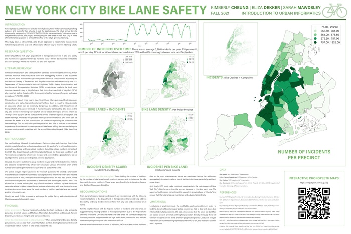
Intro to Urban Data and Informatics
This course provided an introduction to the technical, theoretical, and practice-based dimensions of urban analytics. It centered around data acquisition, numerical analysis, spatialization, visualization and interaction, and civic technologies. Students learned major concepts, software tools, and analytical techniques to extract meaningful information from various data sources. Students then developed projects that combined these technical aspects into a final analysis and visualization.
Students: Shreya Arora, Kirthi Balakrishnan, Sebastian Bielski, Christian Budow, Jidong Cai, Michelle Chen, Kimberly Cheung, Kit Nga Chou, Boyang Dan, Eliza Dekker, Zhaoxuan Duan, Margaret Hanson, Nabila Hawali, Hilary Ho, HaoChe Hung, Lizzie Lee, Jonathan Marty, Sarah Mawdsley, Hazel Ni, Yixuan Ouyang, Eve Passman, Sebastian Salas, Yining Shen, Tiffany Vien, Fang Wan, Daniel Wexler, Mia Winther-Tamaki, Wei Xiao, Ya Hsuan Yang, Zhaoxiang Yun
Fall 2021
Planning Methods
This introductory course is designed to help prepare students for common analysis methods used in planning practice. Common methods of analysis are covered using publicly available data sets and data collected through assignments. Through weekly readings, lectures, and lab sessions, students gain a basic understanding of the tools and skills required in planning practice.
Spring 2022
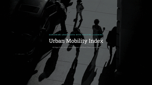
Exploring Urban Data with Machine Learning
Urban planning decisions are inherently difficult, as cities comprise systems of immense complexity and increasingly large volumes of data. While planners are not new to qualitative and quantitative tools to model such decisions, this course engaged the role of technologies in the planning process by focusing on challenges and advantages gained from three new skills in particular: data munging, machine learning, and data visualization. Students learned to apply the skills and techniques necessary to describe, model, and evaluate their results alongside the history and theory intersecting technocracy and urban planning.
Students: Kirthi Balakrishnan, Christian Budow, Jidong Cai, Michelle Chen, Kimberly Cheung, Sean Chew, Kit Nga Chou, Boyang Dan, Ningyuan Deng, Hilary Ho, HaoChe Hung, Lizzie Lee, Rae Lei, Moses Levich, Shuhua Li, Danqing Ma, Brady Meixell, Eve Passman, Danielle Roberts, Yining Shen, Katherin Sibel, Fang Wan, Wei Xiao, Shen Xin, Ya Hsuan Yang, Jiayi Zhao
Fall 2021
Planning Frameworks for Equitable Climate Action
Climate change multiplies existing city risks, including those related to housing affordability and quality, health and wealth inequalities, and aging infrastructure. However, addressing climate change provides an opportunity to address historical inequities, leveraging new actions that reduce greenhouse gas emissions and strengthen community climate resilience to benefit an area’s most vulnerable residents. This course situated climate action in a local planning context, exploring different approaches and tools to help planners address the twin challenges of climate change and inequality. It focused on three broad topic clusters: equitable greenhouse gas mitigation policy, collaborative governance structures to scale equitable climate action, and community planning. Course materials were drawn from policy documents and analyses; non-governmental organizations including environmental justice, social movement, and climate action groups; and mass media.
Students: Clayton Anderson, Sean Chew, Gabrielle Coleman, Carlos Miranda Pereyra, Morgan Reuther, Yuanyuan Shen, Eshwatti Sookram
Fall 2021
Environmental Data Analysis
This course introduced methods of environmental data analysis across varying geographic scales and underlying planning issues in the context of climate change. Structured through four modules—Global, National, Regional, and City—the course introduced students to the variety of environmental data and analyses for different geographies. Each module underscored planning approaches to climate change, including addressing rising temperatures and urban heatwaves, energy supply vulnerability, and the challenge of mitigating greenhouse gas emissions through compact city simulation and planning for urban heat island adaptation. Students mastered spatial suitability, data management, scenario development, and machine learning to answer scale-specific research questions. The course used analytics that will propel planners into the world of big data and help model the complexities of climate-change-related environmental processes.
Students: Tamim Abedin, Sean Chew, Erik Strand, Shiyue Wu, Zhaoxiang Yun
Fall 2021
Geographic Information Systems
This course introduced core concepts of Geographic Information Systems and the science and technical skills critical for working within urban environments. Students learned critical approaches to spatial analysis and visualization techniques as well as data acquisition and management, spatial research methodologies, and cartographic principles through a combination of lectures and focused lab sessions.
Students: Sarah Abdallah, Kirthi Balakrishnan, Zhihao Bao, Natalie Bartfay, Sebastian Bielski, Ariana Bon-Hodoyan, Christian Budow, Jidong Cai, Tomas Carrillo, Michelle Chen, Kimberly Cheung, Sean Chew, Kit Nga Chou, Stacey Hiu Man Chui, Gabrielle Coleman, Rozette De Castro, Eliza Dekker, Zhaoxuan Duan, Mekarem Eljamal, Margaret Hanson, Calvin Harrison, Nabila Hawali, Hilary Ho, HaoChe Hung, Siyun Ji, Dmitri Johnson, Jim Lammers, Lizzie Lee, Theodore Leventhal, Victoria Lin, Mollye Liu, Fukunda Mbaru, Nikolas Michael, Carlos Miranda Pereyra, Hazel Ni, Alisa Nurmansyah, Geryel Osorio Godoy, Morgan Reuther, Robert Sanchez, Matthew Shore, Jillian Solomon, Hyuein Song, Eshwatti Sookram, Kevin Tang, Varisa Tantiwasadakran, Kyliel Thompson, Sabina Unni, Sofia Vala, Fang Wan, Ziming Wang, Daniel Wexler, Mia Winther-Tamaki, Andrea Wong Magnalardo, Siyu Xiao, Wei Xiao, Ya Hsuan Yang, Ruiqi Zhu

Fall 2021
Climate Justice in Our Own Backyard
In this practicum, students learned about the disparate impact of the climate crisis within New York City’s neighborhoods and explored solutions to help them adapt. The course took a critical perspective on the local urban policies and projects evolving over the last two decades including blue-green infrastructure, coastal protection, buy out and retrofit programs, changes to building code and zoning, updates of flood maps, and various initiatives launched in the wake of Hurricane Sandy in 2012. It also explored community-driven efforts to advance climate justice, social resilience, and a just transition to a post-fossil fuel economy. Through student-led workshops with local climate justice leaders, students helped the NYC Mayor’s Office of Climate Resiliency develop a communications tool for the City’s forthcoming Climate Adaptation Roadmap.
Students: Shreya Arora, Julia Boger-Hawkins, Kit Nga Chou, Emily Davis, Rozette De Castro, Dannie Dinh, Maya Dutta, Jennifer Evans, Georgia Grzywacz, Iris Simone Haastrup-Sanders, Jiaxin Li, Shuhua Li, Victoria Lin, Danqing Ma, Jonathan Marty, Achmad Maulana, Nikolas Michael, Lucy Nicholson, Jiabao Sun, Rongxin Tang, Sabina Unni, Jolie Villegas, Yue Wei, Jiayi Zhao

Spring 2022
Urban Design for Planners
How should urban designers give shape to the city? What urban design methods could they apply? This course helped students acquire the principles that inform urban design practice. It had three major pedagogical objectives. First, it helped students understand the contemporary city through a series of urban design tools. Second, it covered both historical and modern urban design principles. Finally, it included all the scales in which urban designers operate, ranging from the fundamentals of social interaction in public space, to environmental sustainability of a region. The course was structured around the most typical problems that urban designers will be asked to solve. Each week, students applied key urban design readings to research and design exercises that built a fundamental urban design understanding and skill set.
Fall 2021
Metropolitan Planning
This course explored strategies for planning metropolitan regions with a special focus on the institutions and issues that transcend local political boundaries including transportation, resilience, housing, and governance. Drawing on the experiences of the Regional Plan Association’s four landmark plans for the New York region and national and international case studies, the course analyzed the success and failure of various strategies for protecting open space, addressing the challenges of climate change, supporting economic development and affordable housing, and investing in transportation infrastructure. What models have been successful in addressing these challenges? What new structures will be needed in the face of economic and technological changes? And how will society pay for the investments necessary to create fair, sustainable, and prosperous metropolitan regions in the future?
Students: Zhihao Bao, Sebastian Bielski, Derek Brennan, Jackson Fordham, Sori Han, Soyeon Kim, Moses Levich, Aria Ling, Alisa Nurmansyah, Danielle Roberts, Tiffany Vien, Shen Xin, Ruiqi Zhu
Theses and Capstones
Urban Planning Class of 2022
SHREYA ARORA
Urban Politics of Death: Memorabilia and Mutual Aid amid COVID-19 Pandemic in New York City
Advisor: Ryan Devlin
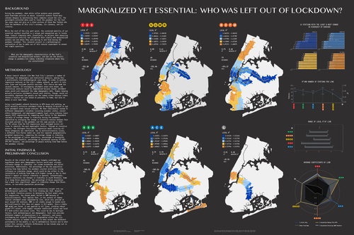
The thesis focuses on inquiring about, what were the challenges faced by low income immigrants in NYC through crisis, loss and memory brought on by the COVID-19 pandemic? How did the ‘Mutual Aid’ social networks supplement the City Agency’s role within these communities? The objective of this thesis research is to identify the City Agency affiliated gaps experienced at grassroot levels by vulnerable populations during moments of public emergency and how social networks and role of ‘mutual aid or self-help’ organizations play an active role of public support in mitigating such challenges. While City Agency initiatives provided temporary relief to those who were able to avail it, the insulating nature of these new grassroot efforts of community organization moves beyond questioning why the already existing social systems and planned programs failed to be approachable and accessible to all.
As planners, it becomes critical for us to engage in what are these binaries that are continually followed by systems of governance and retained informally by community solidarity during emergencies in a city. The research uses a qualitative framework incorporating reflexivity with a methodology of triangulation for data collection and analyzes semi-structured interviews with 18 Mutual Aid Group representatives in New York City to answer the above research questions using an integrated approach of inductive-deductive thematic analysis framework. Borrowing from the discourse of urban informality, governance and politics of the state and ‘people-centered’ urban planning, this thesis highlights the context of COVID-19 and associated politics to understand the dynamics of marginalization of vulnerable communities and co-production transformations of such social networks. Mutual Aid alliances therefore, can be seen as the smallest unit of civic construction at its unit level that harbors sustained local community belonging, being the nexus between informal social networks and formal City Agency governance especially during public scale crises and urban emergencies.
DEREK BRENNAN
Crisis Management: Bureaucracy, Austerity, and Managing Homelessness in the Temporal Camp
Advisor: Bernadette Baird-Zars
Housing is a crisis, and in lieu of a resolution, its fallout is managed through time indefinitely. New York City administers homeless services through intensely bureaucratized structures and by a logic of austerity that reserves public assistance only for those who ‘truly need’ it. My thesis argues that this intersection of austerity and bureaucracy produces a permanent class of unhoused people who, in their lived reality of crisis, very much need public assistance, but in the eyes of the bureaucracies that administer this assistance, do not need it enough. The result is that their crisis continues in perpetuity. I make this argument by drawing from my own ethnographic research in New York’s Lower East Side with people who are unhoused and who are members of this permanent crisis class. For those who I have interviewed, bureaucracy is much more than the particular agencies that provide or deny them services. It is a broad governing structure that manages their lives in shelters and in public space, that suspends them in an alienated time of crisis indefinitely. I use Agamben’s (1998) notion of the camp to elucidate the indistinct temporality my informants occupy when permanently anchored at the bottom of waitlists to receive assistance. Finally, I ground these findings in the context of the real estate state (Stein 2019), which oversees the biopolitical economy of housing, and which produces, manages, and benefits from the ongoing housing crisis.
BOYANG DAN
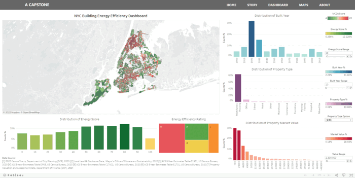
An Interactive Dashboard: Building Energy Efficiency Justice Analysis in New York City
Advisor: Bernadette Baird-Zars
Climate change is one of the greatest threats to New York City. Continued rising heat, sea level rise, and extreme weather times threaten urban residents, communities, and our built environment for the foreseeable future.
Buildings account for two-thirds of New York City’s GHG emissions. A large portion of the buildings in NYC are already built. This reality makes retrofitting existing buildings critical important and improving the energy efficiency of existing buildings becomes critically promising. New York City has introduced a number of laws and programs in place to improve building energy efficiency. The energy efficiency rating is one of the most direct and also one of the most widely used indicators of building energy efficiency, which is used to evaluate building’s energy consumption, overall comfort, and energy costs. The research question for this capstone is the characteristics of Energy Star Score in terms of their distribution in time and space. This capstone first uses statistical methods to analyze the distribution of Energy Star Score by timeline, building type, and other factors. Then, linear regression analyzed the relationship between Energy Star Score and building-related factors. Finally, the Multi-Criteria Decision Analysis method is used to analyze the Energy Star Score geographically.
The main goal of this Town + Gown capstone is to examine the performance of building energy efficiency across New York City based on this Energy Star Score through spatial analysis and regression analysis, and also identify areas where low levels of building energy efficiency intersect with environmental justice indicators such as low-income population and non-white population. The primary output of the capstone is a platform with visual interactive energy efficiency maps and a straightforward dashboard that can be easily manipulated to display visual statistical and spatial data. The deliverables of this capstone are intended to serve the decision-making needs of relevant NYC agencies and other stakeholders, such as environmental justice groups, landlords, investors in building retrofits and community advocates.
Firstly, this capstone uses regression model to analyze the factors associated with Energy Star Score and found that low-income population and non-white population were associated with Energy Star Score. Next, using the Environmental Justice Index cites, this capstone calculates the Building Energy Efficiency Justice (BEEJ) index at the census tract level, combining low-income population and non-white population. Secondly, this capstone uses the Multiple Criteria Decision Analysis (MCDA) method to refine the BEEJ scores that may be inflated by combining the number of D-graded buildings.
Finally, this capstone created an interactive dashboard using statistical and spatial data built on the GitHub platform and written using HTML, CSS, and JavaScript. The dashboard first uses a scrolling map to provide a spatial narrative story about Energy Star Score and Building Energy Efficiency Justice (BEEJ) scores for any audience unfamiliar with Energy Star Score. Next, the dashboard uses Python and PostgreSQL for data analysis and builds an interactive data dashboard through the Tableau platform. The dashboard combines spatial and statistical data to provide stakeholders with intuitive data visualization. Finally, the dashboard develops interactive maps that provide spatial visualization of BEEJ and MCDA maps. The dashboard’s full database is updatable and publicly available for download in preparation for possible future research purposes.
JIANWEN DU
Evaluation of Local Zoning Regulation and Policy on Housing Affordability Crisis in New York City
Advisor: Boyeong Hong
New York City has experienced rising unaffordability in recent years with the following housing crisis that impacts local communities, pushes out our people, and makes the city less welcoming. In this challenging time, the research highlights the important role of local government and its zoning regulations in easing the severe affordability crisis citywide, which can not only affect the supply of housing units but can be used as incentives to leverage private capital in developing affordable units. To better guide future housing development, the research aims to evaluate local zoning regulation and policy on affordability crisis and approaches it by introducing the view of local housing needs into the °∞3E°± framework (efficiency, effectiveness, and equitability). The findings reveal sorting of the population by income, job occupants, and race in the communities citywide, inequity in the region-wide distribution of residential land use without fully addressing local housing needs, and less effective land-use change that exacerbated housing need divergence across the city. Meanwhile, the research points out the potential opportunities to make the proper land use actions in areas with high transit access to accommodate more housing supply. As for inclusionary zoning policies, the research presents the transformation of policy design to respond to a severer housing crisis with stricter restrictions on developers. The analysis shows that inequity distribution of affordable units in neighborhoods, especially in the weak market of the city, low effectiveness of policies outcomes compared to the whole city°Øs construction volume, and low efficiency for some aspects of policy design, which cannot fully address current pressing housing needs. Also, the implications of results on policy design are proposed in the research. However, this research does not examine the direct effects of land-use change or affordable housing provided on housing production or costs, which is worth further research in the future.
HK DUNSTON
WAKE UP ALL THE BUILDERS: Fatigue and Utopia In Washington Heights and Inwood
Advisor: Hugo Sarmiento
This study explores community leaders’ perceptions of the future of the New York City neighborhoods of Washington Heights and Inwood. Taking an ethnographic approach, the author conducted in-depth interviews with community leaders about neighborhood challenges and potential futures. In addition, the author observed neighborhood events and Community Board meetings over two years from 2020 to 2022, while also reviewing historical analysis and social media discussions. The study asked informants to imagine utopian and dystopian futures of Washington Heights in 2050, eliciting their aspirations, fears, and expectations for the neighborhood. Through these discussions, the author developed an ethnography of the future, illustrating informants’ expansive visions for more just societies built on care, equity, and the celebration of new ways of being in the world, where complex biodiversity ensures healthy soil and productive growth, both literally and metaphorically. However, this research also makes clear that future visions cannot be understood independently of the troubled history of the neighborhood as well as its challenging present, which has been steeped in the fear and fatigue of the Covid-19 era. Acting on the collective aspirations for the neighborhood in 2050 requires imagining the repair of injustices from the past, identifying the traces of repair that exist in the present, and carrying forward those traces toward an emancipatory future.
JACKSON FORDHAM
Modeling Toll Price Impacts on Traffic Volume in New York City
Advisor: Boyeong Hong
Readers: Anna Stokes and Josef Szende
New York City (NYC) is currently developing a congestion pricing policy called the Central Business District Tolling Program (CBDTP). One of the organizations that has advocated for congestion pricing is the Regional Planning Association (RPA) who also serves as the client for this capstone project. This project attempts to answer the following research questions: How can the CBDTP policy decisions be explored for the best possible options for toll prices using traffic volume modeling? How does the toll prices on NYC bridges and tunnels impact traffic volume? This capstone project utilizes mixed methods in an exploratory-sequential approach design. The principal method applied isa quantitative study with a complementary preliminary qualitative study. The qualitative methods applied are semi-structured interviews with professionals in the transportation planning sector who provided information on how planners typically approach understanding policy impacts such as the CBDTP. The quantitative research is conducted in a three part methodology: defining variables, using supervised learning modeling to analyze the correlations between historical traffic volumes and the other features analyzed, and predicting traffic volumes for each crossing based on predicted values of the independent variables using the best performing model. The dependent variable for the analysis will be traffic volume. Independent variables for the analysis include toll price, population, economic factors and temporal events and include 142 features in total that were collected and organized. 42 different Machine Learning models are tested. A Gradient Boosted Regression Trees (GBRT) model is found to predict traffic volumes with high accuracy using only toll prices and employment. This model as well as the limitations and findings of the analyses are incorporated into a report as well as a website for the client, RPA.
SORI HAN
Developing a New York City Open Streets Economic Impact Study Plan
Advisor: Ryan T. Devlin
The New York City Open Streets program was first introduced in May 2020 as an emergency program and has become a permanent part of the New York City landscape. Since then, the program has been transforming many streets into public spaces by closing its corridors to vehicles through traffic and being open for pedestrians and cyclists. Open Streets has continued to evolve as a recovery tool to not only include outdoor dining, but also feature cultural programming, the ability to socialize safely, and other layers that promote the use of streets as public spaces. As existing studies have already proved, it is no surprise that the Open Streets program, like other public space programs and street improvement projects, has had a positive impact on the community economic development.
However, as the program has grown citywide in such a short period of time, there are no existing plans or tools to measure and evaluate the impact of the program on the surrounding businesses and the community. Although NYC DOT has evaluation tools for the past public space programs and street improvement projects, there needs to be a customized tool for the Open streets program as it has a number of distinct characteristics from the other programs. Furthermore, most of the existing tools for measuring the economic impacts of changes to street environments are weakened by their lack of quantitative methods or comprehensiveness. as they primarily focus on qualitative surveys of consumers and business owners. While anecdotal evidences from business owners indicate that their sales improved by participating in Open Streets programs, quantitative data capturing the impact of Open Streets on local businesses, like how much consumers spend, will be key to developing and establishing a sustainable program.
In this regard, working with the Regional Plan Association and Alfresco NYC, this capstone produced the Open Streets Economic Impact Study Plan to understand the contextual economic impact in both a qualitative and quantitative manner, as well as conducted an economic impact analysis on Amsterdan Avenue Open Streets to demonstrate how the impact study plan and tools can be used.
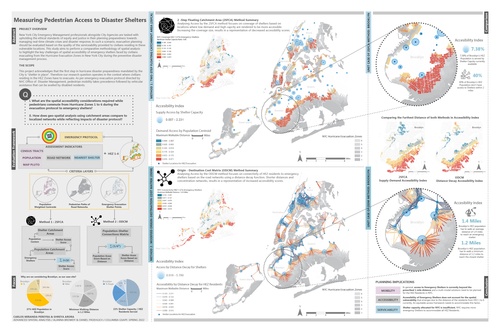
GIZEM KARAGOZ
Beyond the Flood Maps: Post Hurricane Ida Flood Risk, Housing Informality and Community Based Recovery to Adaptation Narratives
Advisor: Hugo Sarmiento
Effects of climate change on different socio-demographic identities, such as immigrant communities, within low-income and informal housing settlements lack sufficient research and analysis. Literature written on the compounded impacts of social vulnerability factors reveal residents living in informal housing conditions are at best ignored by planning policies, as in the case of New York City basement dwellings, and at worst are evicted by housing authorities (Dodman, 2019). These two extreme responses make planning climate recovery and adaptation at the household level difficult without acknowledging and learning from the conditions of informality.
How can New York City plan for future inland flood events and accurately understand the risk posed on vulnerable communities living in basement apartments if it cannot rely on formal disaster recovery and climate adaptation policies and procedures? This thesis argues that centering critical theory and the subaltern can contribute to adapting climate research to conditions of urban informality. This complex challenge at the intersection of informal housing and climate change presents an opportunity to produce theory, knowledge, and policy in conjunction with communities who have experience working with states of informality. In the case of New York City, Community Based Organizations who have developed a history of trust with immigrant communities and their states of housing informality undertake a critical role. Centering the knowledge and experience of CBOs in the aftermath of Hurricane Ida through narrative research reveals the challenges and opportunities to better understand the compounded vulnerability experienced by immigrants who depend on basement apartments in flood zones. It also provides a means to address ‘informality’ in future disaster recovery and climate adaptation planning to encourage stormwater flooding policies that are informed by community needs and build on local assets.
JEAN KIM
The New York City Subway: Invisibility, Crisis, Materiality, Fantasy
Advisor: Ryan Devlin
In many ways, large infrastructural systems like the subway represent a collective fantasy of the city - a shared physical apparatus that shapes individual routines, desires and identities. The subway is what enables the vision of New York City as “The Greatest City on Earth” - “The City that Never Sleeps.” From the day that the first underground line opened in 1904, the subway system has run 24/7, setting the terms for social and economic life in the city.
These visions are enabled by the material infrastructural components that make up the subway system - the train cars, tracks, signaling systems, control rooms as well as the train operators, maintenance workers and MTA officials that operate them. Yet these material and human infrastructures are often rendered invisible because they are valued only for their utility as a means to our ends, causing the material conditions of the system to remain invisible except in moments of crisis or disruption.
This thesis begins by identifying three recent moments of crisis - Hurricane Sandy (2012), the Summer of Hell (2017) and the Covid-19 Pandemic (2020) - that brought the material components of the system into friction with our fantasies of the subway. The post-crisis recovery process forces us to reconcile our individual and collective expectations of the system with its actual material condition. This negotiation exposes the normally invisible socio-political processes that determine which projects and material components are prioritized over others, or what I call the logics of repair. By tracking and categorizing the MTA’s capital spending in the years surrounding these crises through publicly released data and reports on the MTA’s capital plans, this thesis illustrates the ways in which fantasy has mobilized large amounts of financial capital and political will for certain projects at the expense of more critical system-wide repairs.
HANBO LEI
Are Parks Equitable for New Yorkers? Examining the equity of acreage and safety of parks
Advisor: Boyeong Hong
Parks are important for people’s well-being, but historically, parks have worse coverage for vulnerable populations. This thesis examines whether park acreage and park safety are inequitable across vulnerable people in New York City. The network analysis, Cadastral-Based Expert Dasymetric System, two-step floating catchment area method, and weighted average method were used to measure park acreage and safety. LASSO regression algorithm was used to build regression models to detect whether there is an inequity issue so that vulnerable populations have access to less park acreage or worse park safety. The results show that the minority and foreign-born populations have inequitable fewer park acreage but that there is no significant inequity in park safety. Keywords: equity, park, two-step floating catchment area method, LASSO regression.
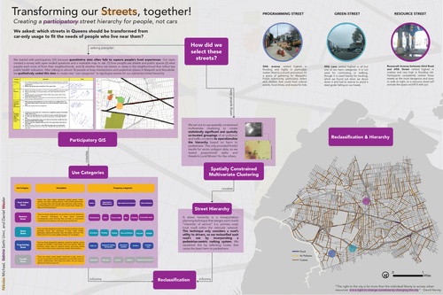
MOSES NARAYAN LEVICH
Prioritizing Streets for Multipurpose Green Infrastructure: A Spatial Framework for New York City
Advisor Name: Ryan Devlin
The Regional Plan Association recommends the City of New York construct green infrastructure on every suitable city street. This goal informs the research aims of this capstone project: where should the city focus its resources to build this infrastructure, and how do different value systems affect this location decision? In this project, I design and carry out a GIS-based MCDA (Multi-Criteria Decision Analysis) that integrates twelve factors, each representing a specific need that green infrastructure could address or mitigate. I then propose a participatory mapping tool that will allow users to carry out their own MCDA according to individual values and priorities. Green infrastructure has traditionally referred to nature-based solutions for a single purpose: generally either stormwater management or shade. In order to better address the multifaceted potential benefits of street trees and rain gardens, this project conceptualizes these interventions as multipurpose green infrastructure. The manifold nature of potential benefits is reflected in the categorization of the criteria used to make the model: access to green space, risk of stormwater flooding, air quality, and socioeconomic vulnerability. Initial investigation into different feature weights reveals relatively consistent patterns: high-priority neighborhoods include Midtown Manhattan, and Bedford-Stuyvesant and Gowanus in Brooklyn. These results are not definitive, and the ongoing development of an online participatory mapping platform will allow a wider range of feature weights. This platform will have the potential to democratize decisions about green infrastructure placement across the city, from the neighborhood scale to the level of individual city blocks. Working towards bottom-up participation in these critical decisions aligns with environmental justice principles as well as the values of RPA and the city of New York.
ZIWEI LING
Evaluating the street greenery equity in New York City, Miami, and Los Angeles
Advisor Name: Hugo Sarmiento
Street greenery has long been identified as an important part of the urban landscape that has a positive impact on climate change, people’s mental and physical health, and so on. In the face of climate change, we need to pay more attention to the benefits of street trees in mitigating extreme climate events such as heatwaves and improving the health and landscape environment of communities. However, most researches on urban greenery merely use overlooking indicators, such as satellite maps, which are usually on a large scale and different from the greenness perceived by people with their eyes. Hence, this article attempts to assess the state of perceived street greenery and equity in three cities: New York City, Miami, and Los Angeles to propose practical street greenery improvement proposals at census tract level.
In this paper, street canopy coverage is used to measure perceived street greenery using Google Street View (GSV). Multiple linear regression models are created to study economic, housing, and demographic aspects that may connect to street greenery in those cities. The results show that in all three cities, street canopy coverage is positively connected with median household income, suggesting that wealthier people may be exposed to more street greenery than poor people. Street greenery may also suffer as a result of urbanization. Furthermore, race composition also impacts street greenery under certain conditions. The percentage of white people in New York City is associated with more street greenery.
DANQING MA
Flood-related Climate Risk Resilience in New York City: The Adaptation of Climate Justice after Sandy
Advisor: Weiping Wu
In the context of global warming and sea level rise, climate issues have caught much attendance from within governments to residents on the street. After the tragic Hurricane Sandy, climate started to drag more people into deeper revisit. Climate justice is a relatively new topic that make people reflect the how climate risk and adaptation is rooted in socioeconomical factors. Growing up with the mindset of top-down decision making and policy application mechanism, I was passionate in learning about the situation in New York.
Titled Flood-related Climate Risk Resilience in New York City: The Adaptation of Climate Justice after Sandy, this thesis aims to have qualitative policy analysis and case studies to figure out the system of Flood-related Climate Risk Resilience and the climate justice aspect in New York City after Sandy.
SARAH MAWDSLEY
Planning for Whom? How the Bias of Urban Planners Impacts Street Improvements
Advisor: Ryan Devlin
Street improvement projects have an unclear relation to gentrification and scholarship has yet to clarify causation, however lower income residents tend to fear displacement as a result of street interventions like bike lanes or street trees and will resist the projects. According to the American Institute of Certified Planners, the role of planners is to serve the public interest, however, if planners and residents hold different views on streetscape interventions in terms of their effect on gentrification, the line begins to blur between what the public interest is and how planners are serving it. Through qualitative interviews with nineteen planning practitioners working in the realm of street and public space improvements, this thesis aims to understand how planners interpret the topic of gentrification within their roles as stewards of public interest and identify common factors that can impact a planner’s perception of public interest. Findings revealed that planners don’t see street improvement projects as gentrifying, and many believe gentrification to be a problem only for housing and community engagement planners. Thus, they don’t see much of a role for themselves in mitigating the negative impacts of gentrification. An analysis of the interviews also show that lived experience is the most significant factor in how planners define public interest. Education plays a critical role in how planners perceive their roles as it provides the foundation of knowledge about the field. Lastly, workplace culture has the most impact when it comes to shaping how planners approach planning. These findings are intended to inform practitioners on how they should revise their planning process to better engage with communities in order to provide them with good planning and design without the fear of displacement.
DAVID MCNAMARA
Managed Retreat in New York City: An Avenue for Climate Justice?
Advisor: Hugo Sarmiento
Reader: Dare Brawley
Physical and social vulnerability to flood risks are not naturally occurring, but instead are socially, economically, and politically constructed through time. Many of the tools proposed in climate change adaptation discussions focus on physical alterations to the built environment, leaving out considerations of social policy. Several contradictions thus arise when considering policies like managed retreat, basement dwelling regulations, coastal zoning and others that aim to protect residents from coastal and inland flooding, in a political economy of housing insecurity, rent burden, wealth stratification, and the retreat of the state from public investments. On the one hand, the arguments to retreat from areas that will increasingly experience acute disasters from coastal storms and cloud bursts and chronic challenges like increasing tidal flood and eventual permanent inundation must be urgently considered; on the other hand, the tools available to retreat and the political economy in which this retreat would take place would likely exacerbate the underlying social factors of risk. This raises concerns about the potential for climate change adaptation and resilience strategies to exacerbate structural inequities to climate risks in places like New York City. This research uses a mixed methods approach to trace the historical development in physically vulnerable parts of New York City and the connections between deliberate policy decisions and market mechanisms to the geographies of risk experienced in those vulnerable areas and to present day challenges experienced by different communities in the face of worsening storms and floods. In doing so, this research argues that policies focused on physical changes to the built environment will worsen inequities in flood risk, even if those physical changes prioritize environmental justice communities. This research will conclude by arguing for the urgency of guaranteeing housing and a livable income as a basic human right as a first step to increasing the housing and financial mobility required to start to address both physical and social geographies of risk.
BRADY MEIXELL
Predicting the Point: New York City’s de Blasio Era Neighborhood Rezonings, Points of Agreement, and How Neighborhoods Navigated these Complex Negotiations
Advisor: Ryan Devlin
In this thesis, I consider how city commitments made in neighborhood rezoning processes were structured and factors that may predict whether promised community benefits were delivered in a timely fashion. My analysis looks at the initial seven Department of City Planning-led neighborhood rezonings during the de Blasio administration in New York City – East New York, Greater East Midtown, Downtown Far Rockaway, East Harlem, Jerome Avenue, Inwood, and Bay Street. I use quantitative analysis of the point of agreement documents, qualitative interviews with relevant stakeholders, and in-depth case studies of four of these rezonings. Using this mixed-methods approach, I aim to break down the political process that gives birth to the POA agreements, provide context behind how POA commitments are structured, and analyze what factors are most likely to lead to the successful fulfilment of a city commitment in the aftermath of a rezoning. Taking the rezoning itself as a given, the aim of this work is to inform future planners how a community facing rezoning can best respond to maximize its potential benefits.
This thesis finds that commitments were most successful when they: were under the purview of the deputy mayor for housing and economic development; were made via capital commitments for projects or new programs; did not require changes to city policy (or its programmatic approach or operations); had a strong and engaged local Councilmember; and when community groups focused pressure and negotiations on requests that were considered more administratively/legally achievable.
YIXUAN OUYANG
The Relationship between Urban Density and COVID Spreading, a case study of Wuhan
Advisor: Ryan Devlin
By 2021, the COVID-19 virus has swept through more than 200 countries worldwide, with enormous impacts on the functioning of cities and the health of people. From the perspective of urban development, the rapid growth of cities over the past 100 years has led to an increase in the density of the world’s largest cities, which has resulted in unparalleled economic benefits. The relationship between urban density and the spread of COVID virus is unclear, as high-density cities may become a vector for rapid spread of the virus in an epidemic, but at the same time, higher urban density provides better public services and resources for people’s health to stop the rapid spread of the virus. In this paper, we try to construct an OLS model from a quantitative perspective utilizing data from satellite image of ESA and Wuhan Census 2020, taking Wuhan city as an example, and investigate the relationship between urban density and COVID virus transmission from a time series-based panel vector autoregression angle.
EVE PASSMAN
Improving Data-sharing in Hudson County, New Jersey
Advisor: Bernadette Baird-Zars
In this capstone, I coordinated with the Corporation for Supportive Housing’s (CSH) Senior Program Managers Gabriel Schuster and Cassondra Warney over an eight-month period to deliver a strategy that will address the lack of supportive housing in Hudson County, New Jersey. Through qualitative research including case studies and interviews with relevant stakeholders, I analyzed the barriers to data-sharing among government agencies, nonprofits, as it relates to HOME grants and Community Development Block Grants. Finally, I proposed solutions that promote more efficient data-sharing and ultimately generate improved housing outcomes in Hudson County. These solutions include advocating for buy-in at the state level, identifying what nonprofits, city, county and state officials’ work relates to homelessness, and designating an official to advocate for improved data-sharing at the state-level.
MAURICIO ENRIQUE RADA ORELLANA
Urban Morphology: A Study of Local Dependencies on Well-Being Metrics in Bogota, New York, and San Francisco
Advisor: Boyeong Hong
The configuration of the urban morphology shapes our behavior, which manifests through urban patterns such as livability, traffic, economic growth, and pollution. This thesis aims a two-fold objective: to deliver a typology of neighborhoods based on their urban form characterization and an analysis of the effects of the form on traffic congestion and pollutant concentrations. The methodology incorporates a quantitative-methods design. First, it encompasses a quantification of the urban form at the neighborhood scale based on the analysis from the literature review. I designed a typology through unsupervised learning to analyze the dependencies between the types and their components with estimated traffic and pollution patterns using statistical and supervised learning techniques. While the cities of study are Bogota, New York, and San Francisco, this thesis aims to provide a generalizable quantitative theoretical framework of the positive or negative effects of the urban form on traffic concentration and pollutant concentrations based on replicable data collections methods. These findings can inform urban designers, planners, and officials to implement density, land use, and street configuration policies or review new infrastructure development. Finally, this modeling framework contributes to the current scarce but increasing literature on quantitative models that forecast built-environment changes at the local scale that can complement traditional city-scale analysis.
DANIELLE ROBERTS
That’s Rad? Nuance, Complexity, and the Future of US Public Housing
Advisor: Bernadette Baird-Zars
Public housing has always been a battleground in the fight between the public and private sectors (Vale & Freemark, 2019). At the same time, the role and importance of Public Housing cannot be understated. One interviewee mentioned, “if a resident is struggling to stay in our housing, what chance will they have anywhere else?” Nationally, the stock of public housing units has continued to age and deteriorate, leading to unhealthy living conditions for its residents. The Rental Assistance Demonstration (RAD) program addresses these capital needs, but this is not the first attempt to improve living conditions. Public housing residents and housing advocates who remember the displacement caused by HOPE VI are rightfully skeptical of relying on the private sector “fix” public housing. Therefore, this thesis aims to answer an urgent question: what are the critical financial, physical, social, and political determinants that Public Housing Authorities make during RAD conversion? Using both decision tree algorithms and semi-structured interviews, this thesis seeks to understand how these conversions occur, which can inform the analysis of tenant outcomes. For example, 45% of conversions do not rely on debt or tax credit financing, and 13% include a transfer of assistance from one building to another. This thesis concludes that RAD is neither the privatization boogeyman nor the savior of public housing. Further analysis of RAD must therefore provide more nuance and complexity to ascertain the strengths and weaknesses of a program that provided the most funding to public housing in a generation.
YINING SHEN
New York’s Attractiveness to Chinese Home Buyers
Advisors: Bernadette Virginia Baird-Zars
This thesis focuses on Chinese buyers’ role, characteristics, and preferences in the New York real estate market by analyzing the following aspects. First, as background and context, the thesis argues that buyers’ logic and characteristics respond to China’s foreign investment policy history. Second, the thesis details that Chinese buyers are not homogeneous but have patterns of group composition and behavior characteristics. Third, it explains why New York’s housing market is a more economical investment choice compared with Shanghai as a comparable representative of Chinese cities. The fourth section outlines findings, drawing an original assembly and content analysis of sixty brokers of Mandarin language, and lists the primary considerations for Chinese buyers when buying houses. Finally, conclusions are drawn based on the analysis above as a summary.
YUANYUAN SHEN
Informing New York City Subway Flooding Solutions Through Sociotechnical Infrastructure Management
Advisor: Weiping Wu
Urban flooding is an urgent problem to be solved as climate change intensifies its threat, and urban subway systems need to prepare for potential flooding. Since the subway network is part of an interconnected infrastructure system, it is necessary to formulate comprehensive plans for infrastructure maintenance and management. Based on official reports, project plans, news, announcements from the government, and relevant research, I have established a comprehensive framework to assess infrastructure management to deal with flooding in New York City (NYC). Drawing from the experience in London and Tokyo I also explore whether their practices can be lessons for NYC in general drainage method, monitoring and maintenance, and mapping and public awareness. From the perspective of infrastructure management, this study helps NYC clarify the gaps in current infrastructure management, including necessity to improve sewage design standards, upgrade the monitoring system, and develop an active mechanism to engage the public.
KATHERIN SIBEL
Advisor: Hugo Sarmiento
Who is the ‘Global North and South’? This academic construct will be used to critically analyze Puerto Rico, and its relationship with the United States, as a case study to investigate how this false narrative affects vulnerability to climatic disasters. The following research is a compilation of my first-hand reflections as a Latina community planner having lived, worked, and studied in Puerto Rico from 2018 until 2020. This academic endeavor was a cathartic experience in collecting the stories of American and Boricua recovery workers engaged in the Hurricane Maria disaster response and recovery from September 2017 until present day.
Hurricane Maria was a humanitarian crisis surrounded by intense media coverage, controversy, and scandal due to both the federal and state government’s lack of action or adequacy. This research uncovers major challenges and themes to post-disaster recovery, and to what extent does Puerto Rico’s historical relationship with the United States affects such challenges. Consequently, why experimenting disaster recovery doctrines, priorities, and practices from the ‘Global North’ complicates recovery planning. Content and thematic analysis was dually constructed into a ‘Global North and South’ perspective through conducting text mining and sentiment analysis of recovery documents and interviews. Doing so, deconstructs whether there exists an ìusî versus ìthemî or ‘othering’ dynamic in recovery planning. Limiting the scope to Hurricane Maria recovery workers and leaders amplifies their personal stories of spiritual resilience and first-hand observations on the recovery challenges and policies being applied to the Puerto Rico. More importantly, it informs how societal and structural racism contributes to disaster risk.
The ‘Global South’ perceptions and frustrations of post-disaster recovery challenges are modern-day colonial systems manifested through the federal reconstruction projects and reporting. In summary, this research uncovers why all these present-day systems collectively prevent(ed) communities from receiving the funding, planning, engagement, and investment necessary to adequately recover and progress toward equitable recovery goals.
ERIK STRAND
Subsidizing Gentrification?: Neighborhood Change and the Expansion of the 421a Geographic Expansion Area
Advisor: Boyeong Hong
In 2008, the Geographic Exclusion Area (GEA) of New York City’s 421a tax exemption program was expanded from central Manhattan to include large swaths of all five boroughs. With a billion-dollar annual price tag, 421a is one of the largest municipal tax breaks to developers in the nation; however, at the time of the expansion, only within the GEA were developers required to provide affordable housing to receive these benefits. Catalyzed by mounting public opposition to 421a, the GEA expansion marked city and state leaders’ commitment to the program as an affordable housing policy capable of combating gentrification and growing inequality in New York City. Despite this show of confidence, the program’s effects on these trends has not been comprehensively analyzed. In this paper, I deploy a mixed-methods analysis of 421a to understand its effectiveness as an affordable housing policy, using the 2008 GEA expansion as a spatial and temporal case study. Through this research, I conclude that 421a directly accelerates the emergence of income inequality and unaffordable housing in New York, thereby creating the very neighborhoods of inequity and exclusivity that it was designed to prevent. In this way, 421a can be categorized as one of, rather than distinct from, the many problematic programs in the neoliberal suite of affordable housing policy that drives American planning today.
JIABAO SUN
How environment colors shape neighborhoods: the case of New York City
Advisor: Boyeong Hong
This paper focuses on colors of the environment and its purpose is to explore how environment colors influence neighborhoods and improve urban colors in cities for the future. Specifically, research questions focus on the spatial distribution of colors in selected neighborhoods and the correlation between colors of the environment and demographic as well as socioeconomic factors.
Based on the above research questions, this study combines quantitative methods with qualitative interviews and observations to guide the analysis. The quantitative part conducts image processing of Google Street View images to distinguish different color patterns, spatial distributions, and other environmental color features. An OLS regression model using demographic and socioeconomic data to figure out the relationship between demographic and socioeconomic factors and colors of the environment has also been run. The qualitative part adopts observations by the author and snowball sampling interviews with residents, urban planners, and designers, as well as policy makers to decline the bias generated by Google Street View images and to help this research be more practical by adding human-based features into the results.
The research finds that new developments are mainly gray and blue colors while old buildings are usually more red and brown colors. Also, recently developed areas tend to have less green as the dominant color than old brick building areas. As for color diversity, the neighborhood with more traditional buildings tends to have higher color diversity than the neighborhood which has more new developments. Color diversity values of different locations inside a neighborhood with similar building types or functions are similar. The OLS regression result shows that median household income and proportion of residential area have positive relationships with color diversity. The quantitative data, qualitative interview results, and the researcher’s observations indicate that the manufacturing land use type has a high possibility to potentially decrease the color diversity of a neighborhood. Last, all interviewees deem that the colorful environment can contribute to better mental health status and there should be harmonious diverse color combinations inside a neighborhood. Based on above results, the author proposes four suggestions: increasing small-scale colorful urban infrastructure, greenery, landscape, and design; planning colors based on context, culture, function, and people’s opinions; raising people’s awareness of the importance of colors through various ways; necessary legislative control for some cities.
TIFFANY VIEN
Evaluating the Built Environment of Innovation Districts
Advisor: Boyeong Hong
Innovation districts are defined as where leading-edge anchor institutions and companies cluster together to connect with start-ups and small businesses (Katz and Wagner 2018). Although there are vast distinctions in terms of form and function, all innovation districts contain three main assets - economic, physical, networking - to create an innovation ecosystem.
The purpose of this thesis is to evaluate how the built environment of cities has morphed through the establishment of innovation hubs and districts. By analyzing the changes to the physical landscape, demographic shifts may also be observed as the formation of these districts may cause existing residents to be displaced or entice newcomers into the area. Two hubs of innovation, Industry City and Brooklyn Navy Yard which are both located in Brooklyn, New York City, will be utilized as case studies. This thesis will pose two main research questions: How has the formation of innovation hubs altered the demographics and built environment of the area? What do these areas of innovation offer and how do they differ from the key components found in formalized innovation districts? Through a comparative case study analysis, findings can be made on how these innovation hubs have influenced two different neighborhoods in the same borough. This thesis conducted a mixed-methods approach through the spatial analysis of the case study sites to identify changes in surrounding areas. Other qualitative methods included site visits to observe and experience the built environment as well as interviews with planners and agents that have been involved with the development and maintenance of these innovation hubs. Assessing the mix of amenities and uses offered in these two locations will assist in determining how certain aspects of these innovation hubs are able to form an innovation ecosystem.
YUE WEI
Evaluating Bikers’ Experience in Guangzhou, China
Advisor: Weiping Wu
Traveling by bike is not only good for the environment but also good for the rider’s health. The birth of the shared bike system undoubtedly provides further conveniences for the citizens. It is significant to understand user experience, as building bike infrastructure and facilities should draw from such understanding. This thesis focuses on understanding bike riders’ user experience in Guangzhou, China. The target populations are 18 – 60 years old Guangzhou citizens who have biking experience. Bike users’ opinions are collected from an online survey and follow-up interviews.
Overall, the results suggest that bike users are moderately satisfied with biking in Guangzhou and agree that Guangzhou needs further improvements in biking safety, cost of shared bikes, accessibility to shared bikes, or bike infrastructure (bike lanes, signage, etc.) to elevate bike users’ experiences. Different groups of population (age, gender, biking frequency) have subtle differences in the satisfaction with their biking experiences. Higher-frequency bikers are slightly more satisfied with biking in Guangzhou. For future implications, Guangzhou could deploy traffic coordinators along bicycle lanes to maintain order and enhance safety. Planning agencies should construct more bicycle lanes in the future. Government and shared bike companies could collaborate and provide discount incentives to encourage bike use. More shared bike stations might be needed in suburban areas.
SHEN XIN
Modeling Containerized Waste Pattern for New York City Housing Authority
Advisor: Boyeong Hong
This project delivers a waste projection tool to assist the Department of Waste Management and Pest Control (WMPC) at the New York City Housing Authority (NYCHA) to improve its service efficiency, maintain the campus environment and address the challenges of climate change. To develop this tool, 2017 to 2021 monthly containerized waste data for 127 NYCHA sites is combined with seasonality, built environment characteristics, socio-demographics, and pandemic data to build a Random Forest Regression model that achieves a 0.92 R2 score for prediction. Semi-structured interviews with sustainability professionals at NYCHA and the New York City Department of Sanitation (DSNY) inform the design and implementation of the modeling methodology. This study derives the finding that population, income, temperature, and residential density are key indicators of residential waste generation and that recycling programs should be implemented on NYCHA campuses to advance the goals outlined in the Authority’s Sustainability Agenda and in the Authority’s agreement with the City and the federal government. This study recommends that the Authority design the recycling programs from a sustainable development perspective to focus on resident education, job provision, and carbon footprint reduction.
YIFEI ZHOU
The Challenges of Deploying Battery Energy Storage Infrastrcuture in New York State
Advisor: Weiping Wu
Clarifying the deployment challenges of Battery Energy Storage System (BESS) infrastructure can better enable the improvement of energy transition. The flexibility of BESS infrastructure to store and deliver energy while avoiding the space requirement of energy generation and transmission systems is conducive to developing net-zero cities. However, deploying BESS infrastructure brings comprehensive challenges for policymakers, investors, developers, and other market participants. From a planning perspective, available financing tools, tax incentives, the legal and permitting framework, zoning and regulation requirements are all potential factors that can lead to deployment obstacles.
At a state level, this thesis clarifies the benefits of developing BESS infrastructure, outlines the process from planning to implementation, points out the key players and partnership, discusses the obstacles to meeting the policy goals, and provides the planning leadership with recommendations for accelerating the deployment process.
ZIXUAN ZHA
The role of stakeholders and their participation network in urban regeneration decision-making in China:A Case study of Yongqing Area, Guangzhou
Advisor: Weiping Wu
Since the late 1970s, urban regeneration projects have sprung up in China in response to the country’s rapid economic growth and urbanization. For a long time, the decision-making process of these renewal projects has been criticized for following an underlying elitism and overlooking the needs of the wide range of stakeholders. A rational stakeholder participation mechanism is required in the decision-making process to solve complex urban problems. Guangzhou, at the forefront of reform and opening up, demonstrated a high intensity of urban reconstruction. This research takes the Yongqing Area Regeneration Project in Guangzhou as a typical case to study the stakeholders and their participation in urban regeneration decision-making in China. Based on the data collected through in-depth interviews, this paper performs stakeholder analysis to identify and characterize the stakeholders, investigate their interdependencies, and provide policy recommendations. The results show that the urban regeneration decision-making mechanism in China has shifted from interventionism to polyarchy. But both the complexity of China’s government sectors and the informal participation of developers impede effective cooperation among stakeholders. And the current public participation remains insufficient due to a lack of intervention channels. Finally, policy implications were drawn in terms of legislation and decision-making mechanisms.