
Foreword
Water Urbanism
The Urban Design Program at Columbia GSAPP is investigating climate response at multiple scales and collaborating with partners in institutions around the world and within the University from science & engineering, journalism, conflict resolution, economics and social justice. We aim to marshal the observations of the world’s best scientists and the agency of design toward action and defined, replicable climate adaptation projects in the world’s most vulnerable regions. Water is constantly in motion, changing states, crossing borders, nourishing (and destroying) life. How can water and urbanism be considered together as a generative frame for urban design practice, social life, and ecological regeneration? The spring semester 2018 urban design studio investigated urbanization challenges in Jordan, spanning from its capital Amman to Aqaba, Jordan located on the Gulf of Aqaba at the northern-most edge of the Red Sea. Once a small fishing village and trading port, today Aqaba is a tourist-centric Special Economic Zone with hotels, artificial lagoons, golf courses and speculative development. Our goal was to develop a comprehensive understanding of water systems and social life and to understand how these systems interrelate with a specificity of context, land, economics, religion and urban-rural pattern. The entire water system of Jordan is highly dependent upon trans-boundary agreements with neighboring countries. A massive conveyance project pumps fossil water from deep below the earth’s surface at the Disi Aquifer (situated to the east of Aqaba, and lying primarily beneath Saudi Arabia) all the way to Amman, making the entire country interconnected and interdependent upon somewhat fragile water infrastructures. At the same time, a new mega-project called the “Red to Dead” is slated to pump water from the Red Sea to the Dead Sea, desalinating that water for usage and replenishing the Dead Sea’s rapidly shrinking basin. Student projects for re-imagining Amman and Aqaba together within this framework combine the exploration of water, economic, social, spatial, and power dynamics to propose new resilient urban forms generated on local resource use and new land patterns derived from water capture and holding systems.
Columbia UD Faculty: Kate Orff (studio coordinator),Petra Kempf, Nora Akawi, Ziad Jamaleddine, Laura Kurgan
INTRODUCTION
Jordan: Water Interdependence
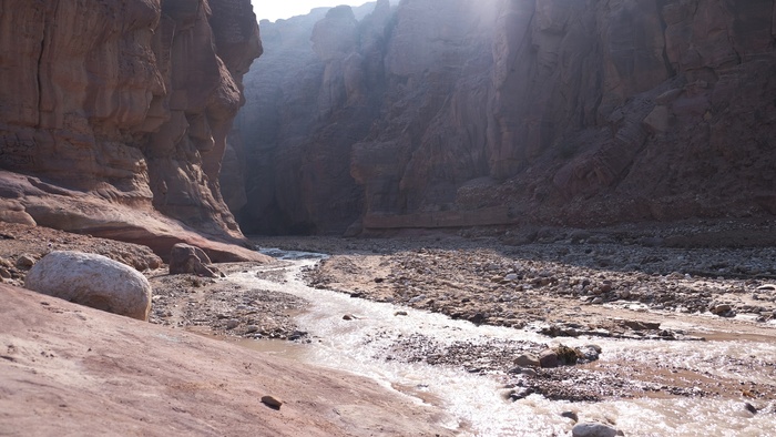
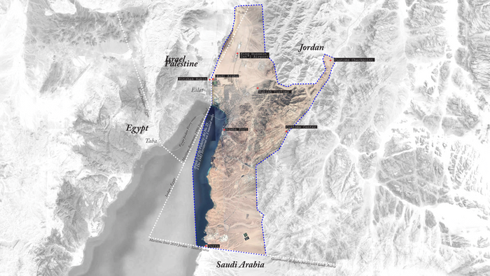
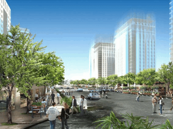
Aqaba is the only city in Jordan with a coastline. Once a fishing village and trading port, it has been designated a Special Economic Zone in order to attract investments in the form of land-based urban development. The Gulf of Aqaba is shared by four countries: Egypt, Israel/Palestine, Jordan, and Saudi Arabia and boasts diverse marine wildlife. It is at the meeting point between two water systems: the base of the Jordan River Valley / Dead Sea rift and the northern tip of the Red Sea. Aqaba is at the intersection of two modes of habitation: global tourist and local denizen/worker or “Aqabawi.” Aqaba is near Wadi Rum and Petra, two sites of international, geological and archaeological importance. With its port and globally focused landscape-driven tourist economy centered on leisure, Aqaba faces many urban issues that parallel other Gulf cities including inequity and segregation.
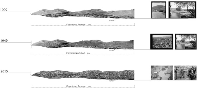
Throughout Jordan and along the Dead Sea Rift, one can discover links between ancient water infrastructure and civilization. Amman, situated to the east of the Jordan River valley (at an average altitude of 1000 meters above sea level), is the capital of Jordan and the country’s economic, political and cultural center. The city has a population of over 4 million (of mixed nationalities) and a land area of approximately 650 square miles of territory. Agriculture and tourism industry demands on the region’s water supply conflict with daily subsistence use by poorer communities and for urban uses, all of which are further exacerbated by regional conflict, and forced population migration. The Red-to-Dead sea mega-project aims to relieve the region’s water stress and restore Dead Sea alarming dropping water level. Many water bodies beyond the Red Sea are in a state of decline with increasing environmental degradation and pollution from human waste and industrial effluent. With Syria enmeshed in a tragic and violent conflict to the North, Saudi Arabia and Egypt to the South, and Israel/Palestine to the east, Jordan has traditionally played a mediating and relatively stabilizing role. However internal and trans-border migration patterns combined with environmental stressors and overtaxed infrastructure and land development have shifted political dynamics.
Within this context, the Studio will learn about and consider territorial strategies for the region and simultaneously focus on specific sites in Jordan along transects perpendicular to Valley water systems and specific communities. We will explore the future of Aqaba as a living organism as it experiences growth, segregation, and land commodification, both on a temporary and permanent basis. We will ask, what are alternative spatial and political organizations possible relative to water new eco-agro-industrial paradigms and economic investments that will characterize next century Aqaba, and how can scenarios that are based on resource recovery advance change?
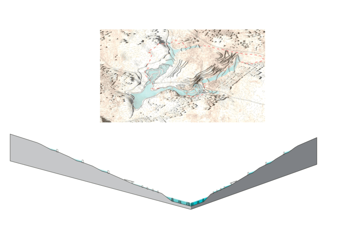
1
Wadi [Re] Urbanization
Students: Betsy Daniel, Janki Shah, Jack Yang Bai, Piyawut Ken Koomsiripithuck
What if wadis are redefined as a new pattern of urbanization driven by logic of water, local values and programmatic landscape?
Wadi - a valley or ravine
A wadi is an Arabic word for a valley or water channel. It is an ephemeral watercourse in arid regions transecting from mountains and foothills pushing water through channels to the lowest points that defines the catchment. It plays a significant role in the formation, occurrence of rainfall, and groundwater reservoir that are replenished through infiltration. They are a vital water source for Jordan leading the water into the Jordan Rift Valley.
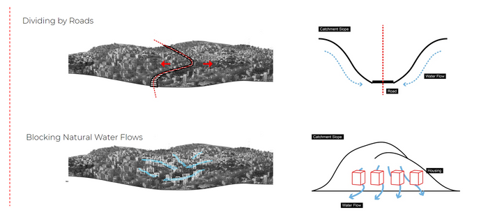
Migratory changes have caused a large influx of population into Amman, the largest city in Jordan. Starting from 1994 and onwards there has been a geographic expansion of the city. This rapid urbanization, population growth, and concretization of the wadi system have posed challenges to the efficient use of the water harnessed from the wadi itself.
Thus Wadi [Re]Urbanization redefines new patterns of urbanization driven by logics of water instead of economic drivers. It uses systems of water retention and collection through ancient water harvesting techniques that rely on earthwork techniques dependent on the existing topography of the wadi.


Diagram of typical wadi
Diagram of wadi urbanization
Diagram of wadi (Re)Urbanization
20th Century Water Infrastructure
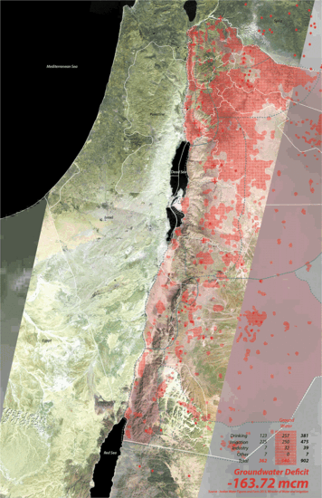
The creation of water infrastructure in the 20th century is fueled by political and economic threats. They are funded by international means that respond to a global scale and methods of development rather than a local scale. The total water usage of Jordan is 902 million cubic meters, however according to the Ministry of Water and Irrigation of Jordan an additional 498 million cubic meters are needed with most of the water going to agriculture. 1
In order to meet this demand, groundwater is pumped from both legal and illegal wells depleting groundwater basins with more than half of these basins having a negative recharge rate, including the nonrenewable Disi basin. Water is being lost through extremely high evaporation at the dams of the water infrastructure, through leaking pipes, illegal wells, and also during transportation through trucks. The government response to these issues is the heavy investment into the Red to Dead Sea Pipeline or the Jordan Red Sea Project. However, this pipeline carrying water thousands of miles to urban centers like Amman, fight against the topography of the existing landscape. They serve as an armature for future development to pop up along it.
The new development promotes international investment and tourism and are in response to economic and political factors rather than environmental and economic values of Jordan. Prior to these concretized infrastructures, cities and villages were mostly ephemeral settlements comprising of local communities. Their dependency on natural springs, intimate understanding of the water and wadi cycle omitted the need of distanced water supply. The Jordan Rift Valley have always promoted groundwater recharge due to sedimentation created by the influx of smaller wadis and because of the higher annual rainfall along the highlands.
The sites along the valley are reimagined as potential infrastructure to revive the wadi cycle and sustain a local system.
Water Infrastructure
Site
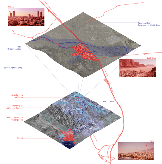
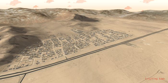
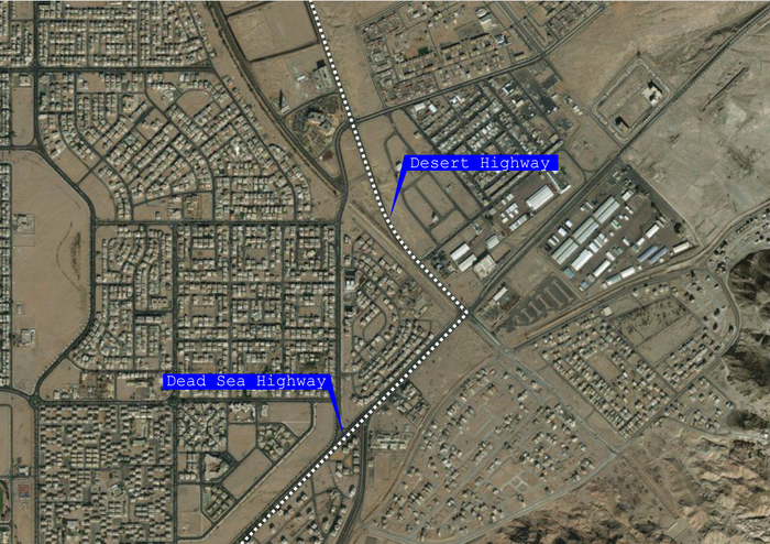
Cities and future development proposals in Jordan depend on highways and roads to dictate city growth and urban pattern. Wadi urbanization concretizes its surface through this highway. For the proposal, we looked at the town Rashidiyah situated near Aqaba in Wadi Yutum as a prototype for the potential and possibility of Wadi [Re]Urbanization. Aqaba, rapidly urbanizing through an economic and road based system under ASEZA, is at the outlet of Wadi Yutum. Several smaller towns and communities, like Rashidiyah, dot the landscape of Wadi Yutum similar to the other wadis in Jordan.
The town of Rashidiyah is located north to the entrance gate of Wadi Rum, a national park popular with tourists. The approximate area of the town is one sq km housing 3,424 people. The water is supplied from the Disi aquifer that is then transferred through trucks. Historically, the town of Rashidiyah was intended to be a temporary settlement. It provided large areas of farmland to the nomadic Bedouin community. After the construction of houses by the King of Jordan, new migrant farmers lived on the land to find work on the nearby large scaled grazing farmlands. Highway 15 runs along the town, and cuts across the existing wadi flow. Hence, our project aims to address existing farmlands and tourism activity in order to be integrated with our wadi development project.
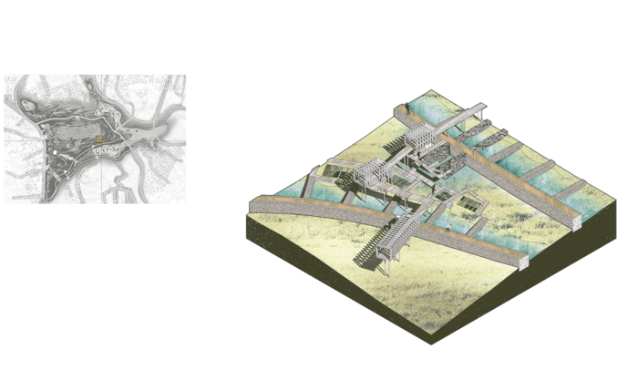
Urban Framework
System
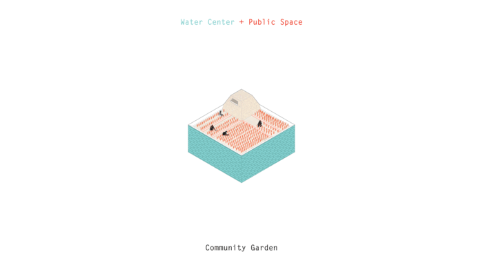
The proposal integrates catchment areas, micro-catchments, rammed earth construction techniques and bioswales to create a module for water retention, collection, and distribution. The catchment area is the predefined area required to store a certain amount of water in a given year and rain cycle. A micro-catchment is a specially contoured area with slopes and berms designed to increase runoff from rain and concentrate it in a planting basin where it infiltrates and is effectively “stored” in the soil profile. The water is available to plants but protected from evaporation. They are simple and inexpensive to construct and can be built rapidly using local materials and manpower. The micro-catchment is attached with a water core using construction material obtained from the earth itself. The water core acts as Persian windcatcher to control the microclimate in a desert region. The entire system is attached to the bioswale and catchment area, creating an integrated water system. 2
This system can be integrated with public space, community living, new housing typologies and new forms of agriculture in varied scales
Water system typologies
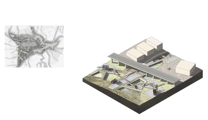
Design Rationale
The existing water and wadi flows were identified by finding the lowest points along the topography. The landform of this highland of the surrounding mountains of the town is manipulated through earthworks to retain water. Catchment areas are clearly defined for the purpose of capturing water for the existing town. This water is dispersed through water channels and bio-swales along the existing street network to water centers in the lower level to reintroduce and imitate natural water flow.
New farm typology, specifically olive farms, crop fields and gazing, are fed by treated greywater from households in the existing towns through natural filtration and treatment ponds along the highway. New farming typologies are created to maximize growth through irrigation from this treated greywater in order to create a new urban network for an agrotourism economy. The lodging and market area along the highway are ancillary buildings to accommodate the growing tourism.
New housing on the north side of the existing town is formed within this water holding landscape. The density is dictated by the capacity of the delineated catchment area that is behind the new housing. Our prototype proposes a water-based density of 1,453 people per sq.km.
We studied our proposal through three transects of the site addressing specific site conditions and speculating their future growth pattern.
Design-intervention-and-phasing-reciprocal-to-site-transects
Phasing
The design proposals extend to time-based development integrating population influx, economic activity, and seasonality.
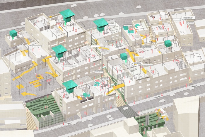
Phase 1 – Existing town grid
In the existing city grid, the water collected from the catchment area behind the town is distributed through bioswales feeding into the existing town fabric. The vacant lots in the city grid are converted into points of collective water centers. These water centers transform into new social spaces varying in scales and functions for the community. They accommodate programs like markets, playgrounds or a training center in order to learn how to deploy these earthwork techniques. In essence, the existing city of Rashidiyah becomes a community water reservoir. When it rains, these water centers or underground reservoirs, become activated, storing water for the future of the town.
The water centers in the existing town perform as a decentralized water distribution network. The water center creates a platform for learning, economic activity and a new way of living. The water center is a new infrastructural system deployed to an existing fabric that will revive the wadi as a resource.


Existing Town
Existing Town
Existing Town
Phase 2 - Agro Tourism
Zooming into the intersection of the existing town, the highway and the land adjacent to the highway, this area provides an opportunity to promote an agrotourism based on tourists taking part in agriculture production, such as olive oil production and processing, which is a growing enterprise in Jordan The buffer alongside the highway, serviced through a combination of stone, gravel, and sand filters takes the greywater from the existing town and pipes it into these new agriculture patterns.The field of agriculture patterns is transcribed based on how much water each crop needs, with the crops needing the most amount of water, such as cabbage, planted closer to the filtration ponds.
It will not only be a tourist place to stay and visit but will also generate long-term economic benefits from this olive oil production and agricultural production. It will be a new destination for the tourists visiting Wadi Rum. Olive harvesting as part of this agrotourism takes place from November onwards offsetting the tourist season of the adjacent Wadi Rum in early spring and fall. The harvest season will be an addition to the incoming tourist flux.


Agro Tourism
Agro Tourism
Agro Tourism
Phase 3 – New town
The north side of the town is envisioned to accommodate a growing population. The ground is prepared before in order to provide areas for holding and catching the water. The manipulation of the earth is to provide pockets for housing that integrate the logics of water through the use of gabion diversion walls and the water core. The new housing typology sits within the ground itself providing the benefit of passive cooling through the earth. Water is also diverted into the new housing cluster through its proximate water catchment area and water center. The integrated water core also serves as a wind tower, modeled after ancient Persian wind catchers that use the coolness of the underground water to chill the dwelling. These new housing typologies are also constructed through the sustainable technique of rammed earth construction. These techniques can be taught to the local residents themselves so that the process can be recreated again.


New Town
New Town
New Town
Wadi [Re]Urbanization is an infrastructural system that can propose urban patterns that work with and grow alongside the existing wadi. It is an experiment in understanding alternative ways in which cities and urban areas can grow and change
Project Video
1 Sen, Z. (2008). Wadi Hydrology. Boca Raton: CRC Press. Ababsa, Myriam, ed. Atlas of Jordan: History, Territories and Society. Beyrouth : Presses de l’Ifpo, 2013. Web. http://books.openedition.org/ifpo/4560.
2 Microcatchment Water Harvesting for Desert Revegetation. (n.d.). Soil Ecology and Restoration Group, (5).
2
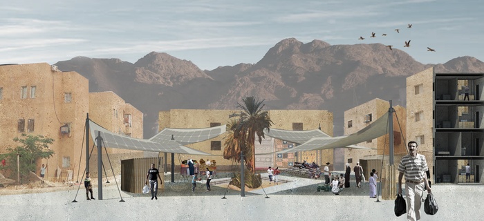
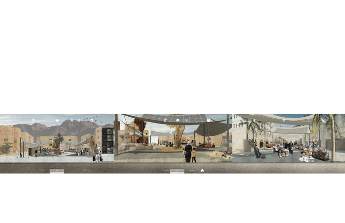
Aqaba 2.0 - Solar Souks
Students: Ke Ren, Sonu Sharma, Xing Wang, Yijie Hu
What if we empower the forgotten people of Aqaba by giving them access to a social credit system based energy consumption?
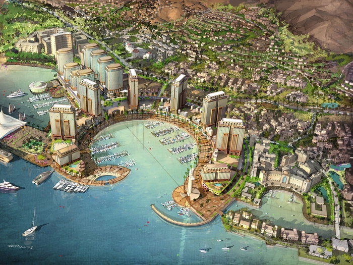
The Aqaba Special Economic Zone Authority (ASEZA) issued Gensler an American architecture, design, planning and consulting firm to create a master plan for the city of Aqaba. The master plan clearly indicates the priorities of ASEZA, which are luxury developments for the wealthy elite predominantly from the Middle East, investing in second homes. These second homes are surrounded by an array of amenities, amongst them a vast golf courses with highly engineered water lagoons that require continuous rotation of water, consuming a tremendous amount of energy.
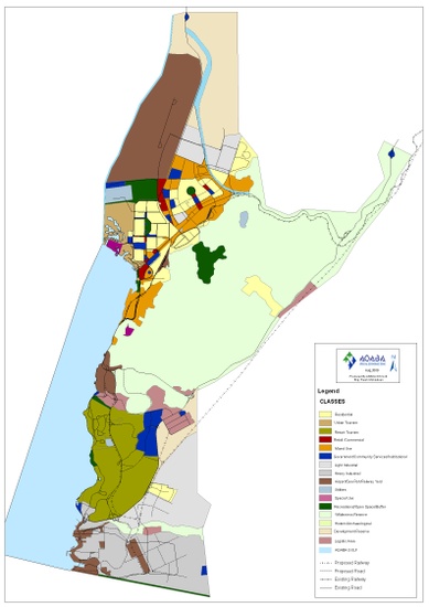
Gensler’s Master Plan for Aqaba
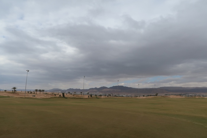
Golf course
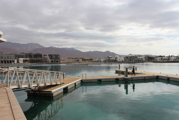
Highly engineered Water Lagoons
Gensler Master Plan for Aqaba
The master plan bypasses the needs of the local people of Aqaba They are considered an invisible entity, highly marginalized. Aqaba has therefore two realities, one that ASEZA projects as a place for luxury developments, the other reality being the forgotten people of Aqaba.


Old Town
Old Town
Old Town
Old Town


Al-Karama
Al-Karama
Al-Karama
Al-Karama
Why is this necessary?
Jordan is highly dependent on external resources. This includes the import of energy, food and water. 97% of the energy is imported, and 45% of the annual budget is spent on imports. Jordan has a centralized national grid system for energy. However, it does not to meet the energy demands; currently there is a 2.3 billion JD/yr deficit. Yet, the government of Jordan requires to invest in renewable energy solutions, which would make a significant impact in the overall economy. The current use of renewable energy sources in Jordan is marginal, accounting for a share of less than 2% of electricity generation. Potentials for generating power from renewable energy resources in the country are to be found primarily in the areas of wind and solar energy.
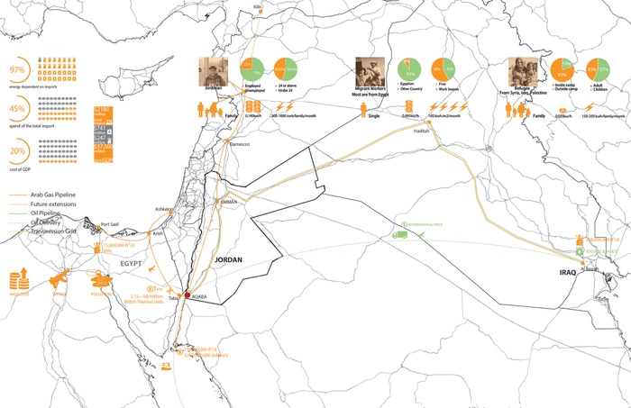
Energy Dependency of Jordan
Where is the project?
Aqaba currently produces 43% of the country’s total energy production. As the only city with a shoreline in Jordan, Aqaba is the only hub able of importing and transporting from inland to the sea. In addition, the city consumes high volumes of energy. Energy, sewage and waste follow a centralized system. Although Aqaba generates energy via solar power, the amount is bare minimum. Low income areas such as Old Town and Al-Karama lack sewage lines and other basic amenities. In addition, Aqaba has only one landfill which is far from the city center.
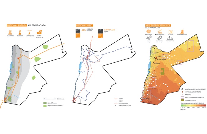
Potential of Solar Energy in Aqaba
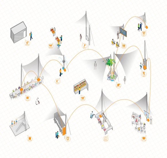
Hub and spokes
Currently the distribution of goods in Jordan is concentrated more in the north including Amman as the only major center. Through our proposal of a hub and spokes model, this project envisions a souk as a trigger to re-establish the local economy in Aqaba based on energy consumption.
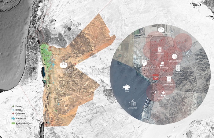
Hub and Spokes model for solar souks
Application based on Social Credit System
The project revolves around the application of an app which is the binding idea to empower the forgotten people of Aqaba. The application is strategized around a hub and spokes model with various different economies, social as well as anthropologic agendas. Within these parameters, the app follows a simple system of input (information) and output (benefits) that results in energy credits, through which the local population can organize their day to day needs, such as managing their waste, healthcare, e-banking, school tuition, as well as paying their energy bills. As the app is being applied, the local population again, is able to participate in the economic life of Aqaba.
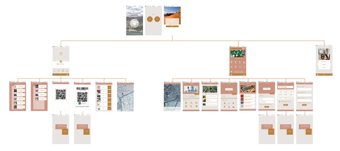
Application Wireframe
Phasing
The project revolves around the creation of a network of souks and sub souks, all equipped with solar technology to facilitate shade and produce energy. The solar souks are intended to grow organically, creating new platforms for economic growth. Each souk is placed at ten minutes walking distance from each other, connected via buses, powered by renewable energies.

Phasing of Solar Hub and Spokes
Unit of Solar Souks
The unit of the solar souks is comprised of four posts, connected via a solar-fabric that creates a canopy to provide shade and energy. As energy is being collected via the solar panels, a battery attached to each unit distributes the collected energy to adjacent vendors. In addition, the slope of the canopy is positioned in a way that water collection is easily to be accomplished. Since each unit is adaptable in its nature and self-sufficient in terms of energy as well as water conservation, the application allows responding to various urban conditions.
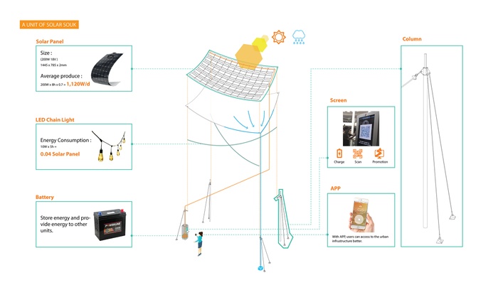
Unit of Solar Souk
Kit of Parts

Unit of Solar Souk
Implementation Plan
To implement the strategy of this energy-based unit, three sites were tested. As each street is unique in scale and character, each unit is adjusted to accommodate its context. For the main souk the units are aligned in a linear fashion. Whereas the other two sites, located in the residential neighborhoods of Old Town and Al-Karama, each unit is organized in a cluster pattern.
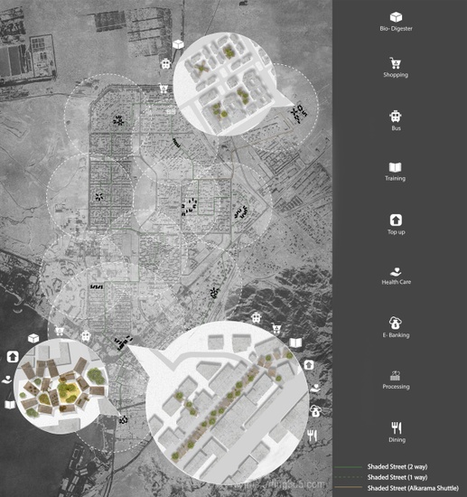
Implementation of hub and spokes for solar souks in Aqaba
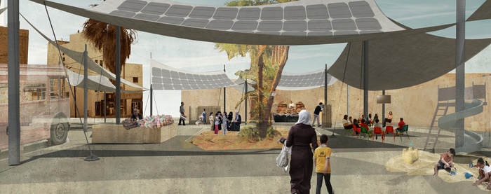
The Main Souk (Hub)
The main souk situated in the downtown area, is the heart of this socio-economic model of the intervention. It will sell goods but also collect energy, exchange information and knowledge by various programs, such as healthcare, e banking, as well as job training. Due to the flexibility of each unit that comprises the souk, the structure could transform according to upcoming events, such as Ramadan.


Main Souk at Downtown
Calendar for seasonal cycles during Ramadan
Main Souk during Ramadan
Sub-Souk at Old Town (Spokes)
The sub-souk in Old Town could hold community workshops, transform into a play area for kids as well as into a bus stop.
Sub-Souk at Old Town
Sub-Souk at Al-Karama (Spokes)
Similar to Old Town, the site in Al Karama could facilitate gathering spaces for the community or workstations to produce arts and craft products as well a provide space for sorting recyclables.
Sub-Souk at Al-Karama
Working of the three sites
The section above illustrates possible scenarios of waste collection through biodegradable waste via bio-digesters. The biogas produced due to anaerobic respiration will be used as cooking gas by the residents. As each of the programs has its own interface in the app, all the introduced programs are supported through local Non for Profit Organizations (NGO), currently present in Aqaba.
Relationship between the sites, app and the NGOs
Project Video
3
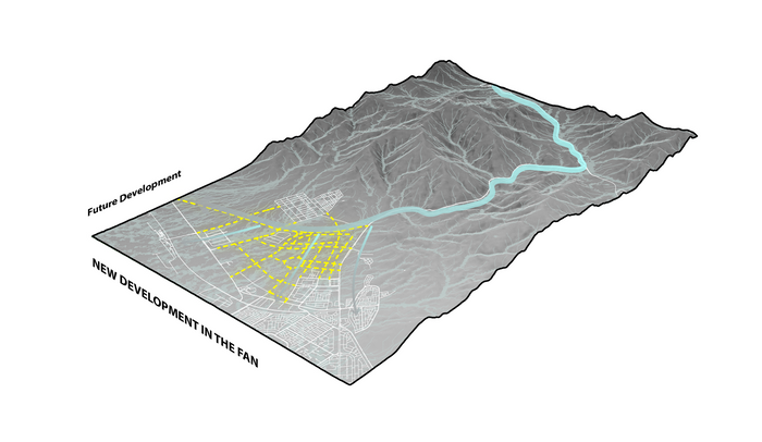
Fan Urbanism
Students: Leslie Chu-Yin Chuang, Tian Guo, Wan-Ting Tsai, Guan Wang
What if an anchor as a top-down operation can trigger a bottom-up landscape transformation at Yutum Alluvial Fan?
Our proposal envisions a responsive landscape of alluvial fans along Wadi Arabah that coexists with an urban settlement. The proposed adaptive system utilizes stormwater and sediments as a productive asset that emerges into a nodal network.
Starting with a top-down operation, stormwater will be reclaimed by decommissioning the existing water channel. As water flows back into the alluvial fan, a testing anchor will be planted accordingly to collect water and sediment as well as to rebuild natural habitat, experimenting soil fertility and water catchment at these points. At locations with more resource accumulation, anchors can be rebuilt as infrastructure units that allow for transportation and utility connections. These infrastructure anchors can expand as a nodal network, collecting and sharing resources such as water and solar energy that sets up the ground for future urbanization.
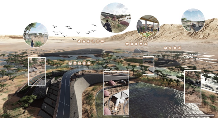
Fan urbanism future vision
Flash Flood in Aqaba
Why would this happen?
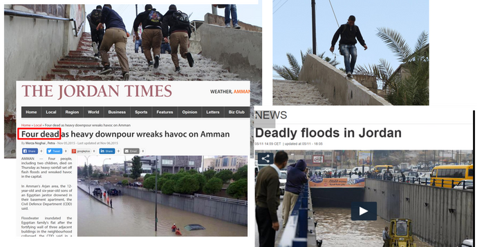
When rapid rain occurs during the rainy season, the movement of high velocity stormwater flowing from the valley causes flash floods in Aqaba.


Flash flood in water channel
Flash flood impact
Flash flood intercepting traffic
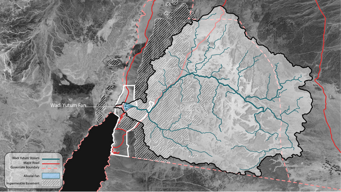
The impermeable ground, mainly composed of granite, has prevented water from absorption. As Wadi Yutum is the only outlet, tremendous amount of water and sediments flow from upstream and discharge into Yutum Alluvial Fan.
Impermeable ground with one water outlet
Water Channel as Failed Infrastructure
Why should we care?
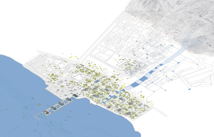
The diversion water channels cut through the center of the existing urban fabric and exposes residents and the city infrastructure.
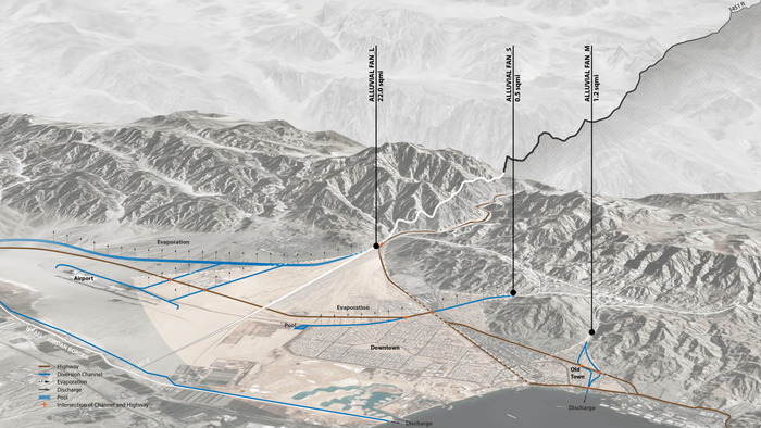
Existing water channels in Aqaba
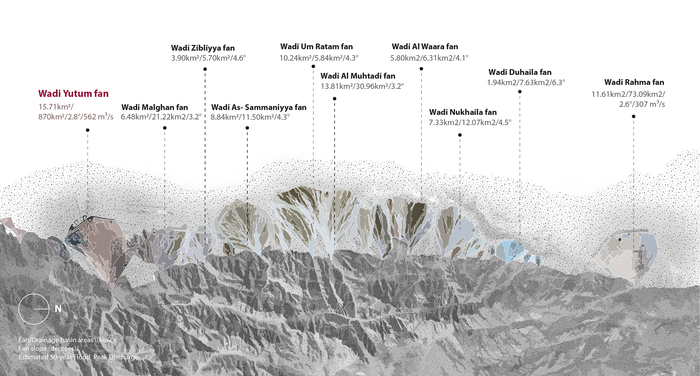
Wadi Yutum Alluvial Fan
Sediments in 3 parts of alluvial fan: proximal, mid fan and distal fan are made up of different sizes of particles with larger stones and gravel at proximal fan, a mixture of fine grained soil and small gravel at mid fan, and sand and silt at proximal fan.
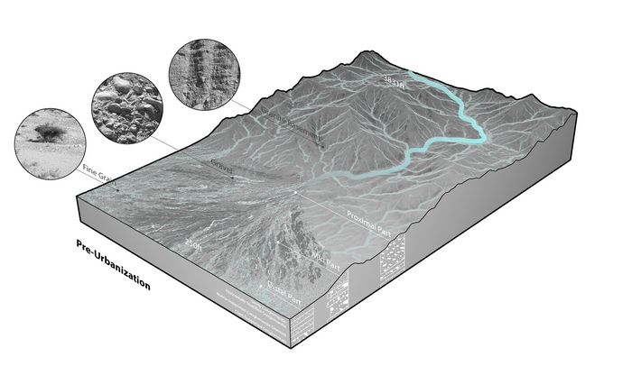
Natural flow of fan (pre-urbanization)
In the past, rapid storm brought flash flood into urban areas in the distal fan.
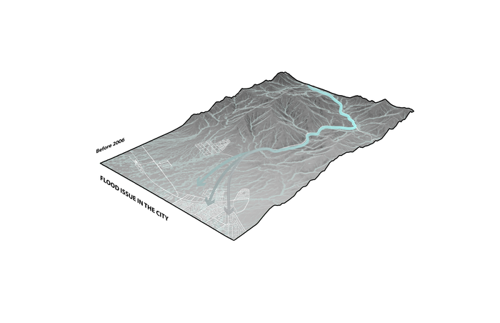
Flood impact on urbanization (before 2006)
After 2006, the municipality relies on channels made out of concrete to channel stormwater, interrupting the natural flow of water towards the opposite direction.
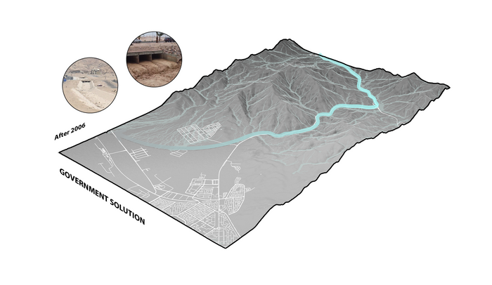
Flood diversion channel as government solution (after 2006)
Based on a master-plan that does not recognize local conditions, a diversion channel has been constructed to accommodate the proposed urban expansion. Since the construction of the channel, several flash-floods have occured and have not prevented the city from being flooded.
Conflict between master-plan and natural water flow (new development)
ADC Master-plan vs. Natural Inhabitation Pattern
The zoning of the master plan does not recognize the urban fabric of Aqaba and the existing landscape, which resembles an alluvial fan. Wadi Yutum Alluvial Fan is the only outlet in Wadi Yutum Basin and plays therefore a crucial role in channeling water towards the Red Sea. In addition, the plan treats water and sediments as waste instead of a resource. Recognizing the alluvial fan as an asset, we propose an adaptive system that utilizes stormwater and sediment as a productive asset to form a coexisting relationship between urban habitation and landscape.


Master-plan program
Luxury apartment complexes
Showroom and business convention center
Medical schools and labor housing
Many alluvial fan case studies indicate that human settlement can coexist with the fan. The common characteristic of these locations reveal the relationship between settlement and natural resources, which directly reflect and respond the unique condition of the landscape.


Italy 1
Iran 2
Argentina 3
Design Strategy: “The Non-Plan Experiment”
“The point is to realize how little planning and the accompanying architecture have changed…and if something good emerges, it remains a bit of a bonus.”
“The one thing that is not being done is the harshest test, the most valuable experiment of all. What would happen if there were no plan? What would people prefer to do, if their choice were untrammelled?” - Non-Plan: An Experiment in Freedom by Rayner Banham
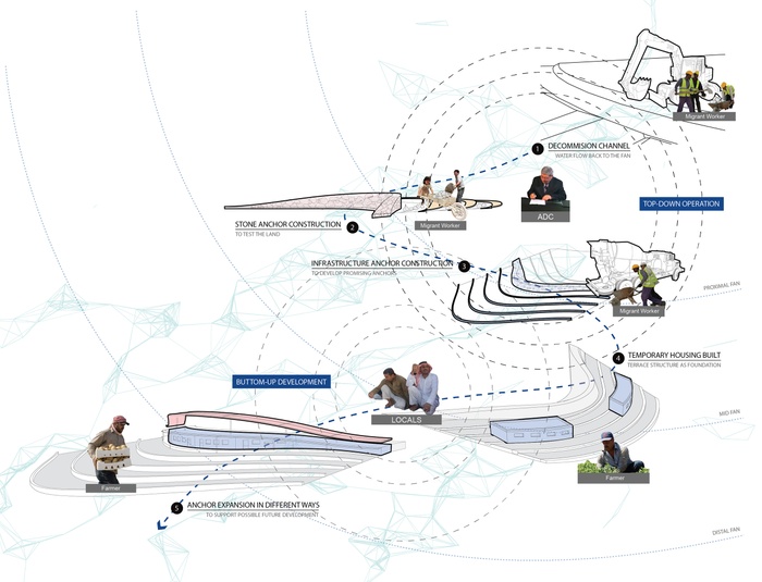
System operation
Our project proposes a top-down anchor operation as an experiment to activate the landscape of Wadi Yutum Alluvial Fan for a bottom-up inhabitation that coexist with the natural water flow, rethinking water and sediment as valuable assets for urbanization.
Design Framework and Typology
Phase 1 - Testing top-down operations
To decommission the water channel, which allows the water to flow back to the fan, Fan Urbanism begins its initial operation in partnership with the Aqaba Development Corporation (ADC). As natural flows of water are reclaimed, testing anchors will be implemented to divide and to hold. The anchor that divides, will filter and slow down water velocity. This is accomplished with silt traps and reinforced terraces around the anchors by collecting sediments and fertile soil as building material and planting resources. Holding anchors will temporarily hold water in low grounds, formed by a cut-and-fill operation. In addition, terraces are constructed around holding anchors to trigger natural habitat growth, which includes water collection.
Phase 2 - Activating bottom-up transformations
In Phase two, the anchors will perform as trigger units of change. They act as testing anchors to experiment where water and sediments could possibly accumulate. Seasonal and temporary settlements may happen at this stage, such as housing units. As resources collect, the anchors may expand and additional anchors geared towards infrastructure will be constructed as a base for urban expansion. In addition to the anchors original function as a dividing and holding device, these infrastructure anchors provide the opportunity to form a nodal network for water distribution and a road system to connect and share resources.
Phase 3 - Expanding for urbanization
When the anchors branches out and expand, the capacity for urbanization may also increase. This is the moment when they provide a platform for solar panels, public space and architectural typologies. In this phase the anchor system is developed as a rigorous network, serving a densified urbanization for the future.


Framework diagram
Testing phase typology
Activating ground typology
Infrastructure anchor typology
Expansion typology
Iteration Sequence
This iteration sequence demonstrates how we envision the anchors to grow in different phases.
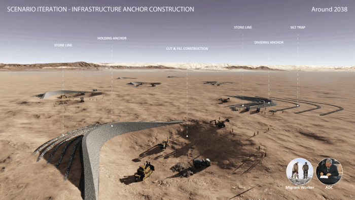
Anchor iteration sequence
How the anchor performs as Infrastructure in a nodal network.


Anchor section
Section of infrastructure systems
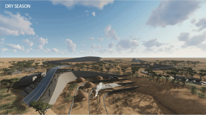
Seasonal Scenarios and Programs
Seasonal scenarios demonstrate how the anchors function as public spaces for different programs during dry season as well as a water infrastructure during rainy season.
Seasonal Change


Transit: resource connection, sediment as building material and food distribution
Trade: seasonal food market
Recreation: sports field
Tourism: camping on the terrace
Public space on anchor
Regional Expansion
Regional expansion
Fan Urbanism is an experiment that challenges parcelized development and rethinks possible bottom-up transformation to allow human settlements to coexist with nature. With the proposed anchor network, we envision a new way of inhabiting an alluvial fan, taking full advantage of its unique landscape condition. This strategy can be a regional model, expanding to alluvial fans along Wadi Arabah.
Project Video
1 Science-soul. (2018). MORFOLOGIA FLUVIALE | science-soul. [online] Available at: http://biziowild.altervista.org/morfologia-fluviale/
2 Society, N. (2018). alluvial fan. [online] National Geographic Society. Available at: https://www.nationalgeographic.org/encyclopedia/alluvial-fan/
3 Earthobservatory.nasa.gov. (2018). Alluvial Fan in Kazakhstan : Image of the Day. [online] Available at: https://earthobservatory.nasa.gov/IOTD/view.php?id=83455
4
Reclaiming the Gulf
Students: Noor Malik, Jose Ponte Neto, Meng Li, One Jea Le
What if, Aqaba recognizes its local economies to initiate a pattern of urban development that is driven by sustainable growth?
Aqaba is the only coastal city in Jordan with an outlet to the Red Sea. Under the Aqaba Special Economic Zone Authority (ASEZA), the city has adopted a model of gulf urbanism often described as “Dubaization” in hopes to emerge as a regionally as well as globally recognized city. With continuous privatization of the waterfront coast for luxury developments and reliance on foreign investment, Aqaba is at risk to develop into an unsustainable model of growth.
Our project envisions to reclaim its productive landscapes within the existing fabric of Aqaba city. By engaging once again, the fishing and farming economies in Old Town, this project envisions to re-establish the lost relationship of Aqaba’s local communities with its land and the Red Sea. With continuous privatization of the waterfront, local fishermen and farming communities have been marginalized and displaced for many decades.
Design Framework
Why is it necessary?
Aqaba flourished as a fishing village and was for a long time a gateway for pilgrims and travelers going to Saudi Arabia and vice versa. Since the establishment of the Special Economic Zone in 2001, Aqaba has experienced an influx of foreign direct investment, most visible in luxury housing developments, often only used as second or third homes. These developments have proven to be unsustainable in their economic value as they bypass the local economies. In addition, their existence have caused the displacement of entire neighborhoods and communities, most visible in Old Town. Aqaba’s port and industrial activities along the shore has generated notable damage to the ecology of the Red Sea, mainly affecting the ecosystem of the coral reefs, upon which the fishing habitat and tourism relies heavily on. In order to visualize the current model of development, we have identified and mapped the vulnerabilities and dependencies of Aqaba in the diagram below.


Aqaba’s Vulnerabilities & Dependencies
Aqaba’s Shrinking Shoreline
Marsa Zayed 1
Where is this project?
To test our framework, we selected Old Town as it offers opportunities to implement our design strategies. Old Town has an existing informal farming ground and a waterfront fishing boats marina. Further, Old Town has a water canal that runs off the rainwater from the hills to the sea. Furthermore, housing in this part of the city has been neglected and mostly abandoned which has caused houses to deteriorate over time. These houses are mostly used by the low income groups, consisting of locals and labour workers. Old Town is one of the last communities that will be displaced due to the new “Marsa Zayed” luxury development just south of the site and “Al-Hafayer Development” project slated to replace the farming and marina on the waterfront.
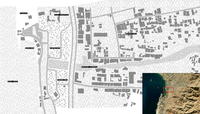
Old Town Existing Fabric


Old Town Existing Fabric
Existing Farming
Existing Abandoned House
Existing Water Canal
Existing Waterfront Marina
What if, we could decentralize the water network to enhance the growth of farming and create new prospects for old town housing?
How?
Our design strategy starts by identifying key actors within the city of Aqaba namely, fishermen, farmer, the marine science station, the fishermen association as well as ASEZA. By creating complementary relationships between these actors, we aim to initiate a new pattern of growth that relies on Aqaba’s local resources rather than depending on global investment. As the fishermen and the farming community have strong ties to land and sea, we have identified them as the agents to trigger change. The production flow represents a unique opportunity to reimagine the local economies of Aqaba.


Production Flow
Existing Actors
Proposed Engagement
Design Phases
The project is divided into three phases of implementation. Phase one begins with two major interventions; a. the construction of a new fishing pier at the waterfront and b. a new network of water channel and holding tanks, distributed within the farming and Old Town housing fabric. Phase two begins with integration of a new modular structural frame for infill housing and social programs, such as farmer’s market, boat repairs, research centers and storage facilities. Phase three represents growth of farming landscape and increased new and reclaimed housing. With implementation of design in these three phases this project aims to revive a new pattern of alternative development.


Design Phase 1
Design Phase 2
Design Phase 3
Site 1- New Pier
Phase one:
At the waterfront, we propose the extension of the existing fishing pier, aiming to benefit local fisherman and to provide adequate space for economic growth. The pier will be the site to house the Fisherman Association and a new branch of the Marine Science Station. By providing the framework in which these two organizations can work together and share knowledge, we intent to make the fishing economy more resilient to oscillation during different seasons.
As part of phase one, the existing water canal will be redesigned in order to decentralize the water collection. The water that runs from the mountains will be redirected to Old Town catchment spots, benefitting the community’s local farmers.


New Urban Pattern of Waterfront
Reclaimed Waterfront
Waterfront Site
Site 2-Farmland
Phase two:
The existing pattern of farming located close to the waterfront of Old Town supports a productive landscape. The proposal aims to preserve the pattern allowing for flexibility and negotiation of land and crop production between farmers. Housing will be introduced as to densify the area and keep farmers close to their land. Within the housing fabric, modular anchors are introduced as community spaces. The configuration of these spaces are also flexible and will depend on the needs of the community. For instance, one anchor is devoted to research and sharing of knowledge, with a Marine Science Station branch, classrooms and accommodation for researchers. Other spaces include community kitchen, daycare and community meeting spaces. Water catchment is part of the anchor to be utilized as a decentralized community resource.


New Urban Pattern in Farmland
Reclaimed Farmland
Farmland Site


Flexibility of Farming Arrangement
Flexibility of Farming Arrangement
Site 3-Old Town Neighborhood
Phase three:
In phase three, we use the same framework as introduced in phase two, but apply different organizational principals. The site of implementation is in the housing fabric of Old Town. Here we implement space for farming within the existing housing fabric. By activating these ‘in between’ spaces we envision to incentivize new growth in the food production economy. In addition, modular structures as anchors are introduced, as well as small-scale water catchment areas.


New Urban Pattern in Old Town
Reclaimed Old Town Housing
Old Town Housing Site
1 Image source : http://www.constructionweekonline.com/article-5700-keo-gets-nod-from-al-maabar-for-aqaba-contract/
5
Unbuilding and Re-purposing a SEZ
Students : Deeksha Kalra, Linda Schilling, Niharika Kannan
What if Aqaba transitions from man-made edge to localized field occupations?
The project is a critique of the solutions developed to confront the water scarcity predicted to hit Jordan in the upcoming years. Based on economic and ecological triggers, the proposal presents a future for the city of Aqaba where two realities coexist. On the one hand, a world that carries business as usual where the Red to Dead water conveyance pipeline project is in full swing. And another one that reclaims the abandoned real estate built stock of the Ayla corporation by occupying and repurposing the man-made shoreline, developing a strategy that goes from edge to a field of hyperlocal economies.


Ayla Edgework, March 2013
Ayla Edgework, May 2012
Ayla Edgework, December 2011
Site - Ayla
Red to Dead pipeline along highway 1
Project Video
Special Economic Zones
Comparing different Special Economic Zones like Shenzen and Dubai with Aqaba helped to rethink the way we deal with SEZs around the world. Even though all these cities originated as a fisherman’s village, each has followed its own growth trajectory. SEZs literally mean: population boom, investment attraction and hyped movement of commodities.
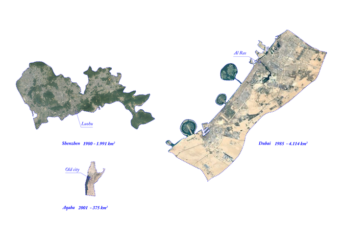
A comparison of Special Economic Zones
Aqaba Special Economic Zone (ASEZ)
The major points of entry into Aqaba are King Hussein International Airport, Aqaba port and the customs checkpoints at the border of Jordan – Israel between Aqaba and Eilat. They are the points of transaction of goods and people.
Points of entry into Aqaba
Scenario Planning
Our project strategy is based upon the methodology of scenario planning devised by the Global Business Network (GBN) in the 70’s. As defined by GBN “scenario planning is not to predict the most probable future, rather the objective is to test and develop strategic choices under a variety of plausible futures.” 2 “Scenario planning is organized around two opposing and independent axes that define future possibility or uncertainty. I.e. representing the factors most likely to change in unpredictable ways.” 3
For this exercise, the two axes chosen are Governance and Design. This scenario planning is dealing with the framework of a Special Economic Zone(SEZ) in the city of Aqaba. Within this framework, the axis of Governance is seen as a world with or without the governing body of ASEZA while the design axis are worlds with a closed or open design feature that is closed as in enclaves- as Aqaba is being planned currently, and Open - as the urban fabric of the old city.


Scenarios and action words
The Scenario axes
The Scenarios
The bottom two quadrants operate in a world where design speculation builds alongside the existing infrastructure of the SEZ, while the upper two quadrants operate in the scenario where the boundaries of SEZ no longer exist and society has to deal with the built environment left behind by the luxury developments. The four scenarios were as follows : Land Caring Society, Post Developer World, Hyper Future Planning and Energy Commons.


Land Caring Society - A micro economy of fertility
Post Developer World - Unbuilding globalism
Hyper Future Planning - The Lane as the new SEZ offspring
Energy Commons - Post fossil fuel energy collection
Roadmap to Aqaba
The image shows two realities juxtaposed against one another where Ayala depicts a localized solution dependent on microeconomic transactions while the red to dead conveyance commentary is a possible consequence of a mega-scale investment. The desalination plant modules on the docks of the marine lagoons become the metric of change in re-imaging this field operation and in the case of the red to the dead conveyance, the belly of the pipe tapping the leakages becomes the equivalent.
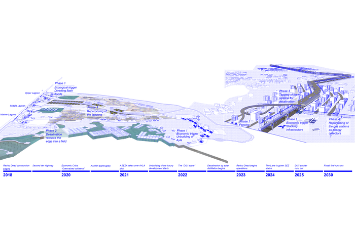
Roadmap to Aqaba
Metrics of change
Ayla
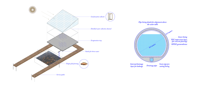
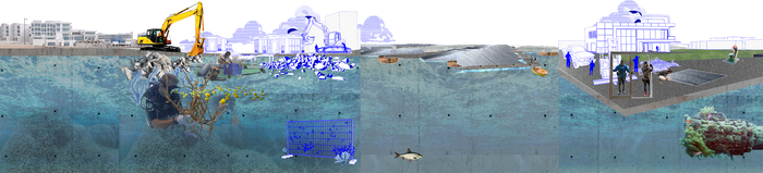
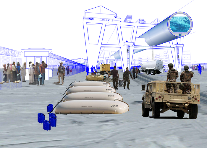
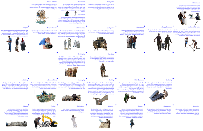
Tapping water from the flash floods becomes the ecological trigger that initiates this field remediation reducing the salinity of the lagoons giving way to a new productive landscape. The DISI scare triggers the prototyping of new desalination process through solar distillation. The brine produced creates new economies of Tilapia fish and spirulina algae farming. Water harvesting becomes a magnet for the akabawi settlers pushing the demand for distilled water. The middle and Upper lagoons are parceled to accommodate a salt scratching economy from the excess brine produced by the growing number of distillation plants. Since the shore of Gulf of Aqaba has a temperature perfect to sustain corals, the marine lagoon acts as a bed for housing coral nurseries.
Field occupations at Ayla
Landscape of Field Occupations


Unbuilding and setting up of coral nurseries
Sediment Harvesting - water channel as a trigger
Desalination
Prototyping and algae ponds
Salt harvesting
The Lane : Red to Dead
This reality is based off the water conveyance project that will transport brackish water from the Gulf of Aqaba to the Dead Sea in an 8 meter diameter pipe to Amman. It is an image of how things could unfold around such a massive infrastructure and not how they should be designed for. The addition of the pipeline leads to a stacking highway situation with a hyped movement of people, goods and sea water. The DISI scare makes this a highly vulnerable resource for tapping and gives way to The Lane becoming a militarized corridor. Water patrollers and engineers tap the leakage to sell water to the water seekers. In the post fossil fuel economy, the gas stations along The Lane are repurposed to facilitate energy supply for distillation by the Water Engineers.
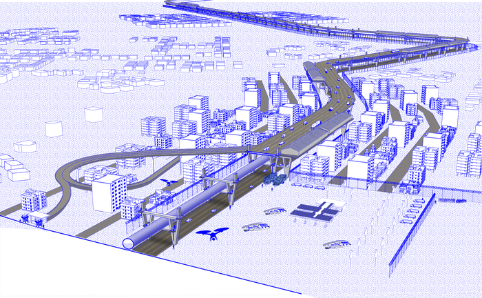
Red to Dead
The Lane
Stakeholders
In the Ayla site, the stakeholders are the Royal Marine Conservation Society of Jordan with registered fisherman and the University of Jordan while the military and USAID become the primary stakeholders in the Red to Dead conveyance site.
Actors
1 Images Source: http://www.ayla.com.jo/ayla-aqaba-project-construction-progress/
2 Global Business Network.(2008,February). Introduction to scenario planning.Retrieved from http://www.mwcog.org/file.aspx?A=53TrgI8fePu9yGIgTG%2BZMVzV8EwawJVtMZ7KAz5ZiBc%3D
3 Spatial Information Design Lab,Graduate School of Architecture Planning and Preservation / Columbia University (2008) Scenario planning workshop. Retrieved from http://c4sr.columbia.edu/sites/default/files/ScenarioPlanning.pdf
6
C for Catchment
Students: Chengyu Xu, Duolin Kong, Keli Wang, Rongchuan Zhang
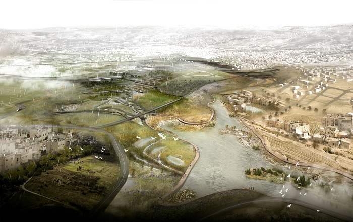
What if Area C becomes a regional park that operates as a productive water infrastructure, supplying the city of Amman with additional water?
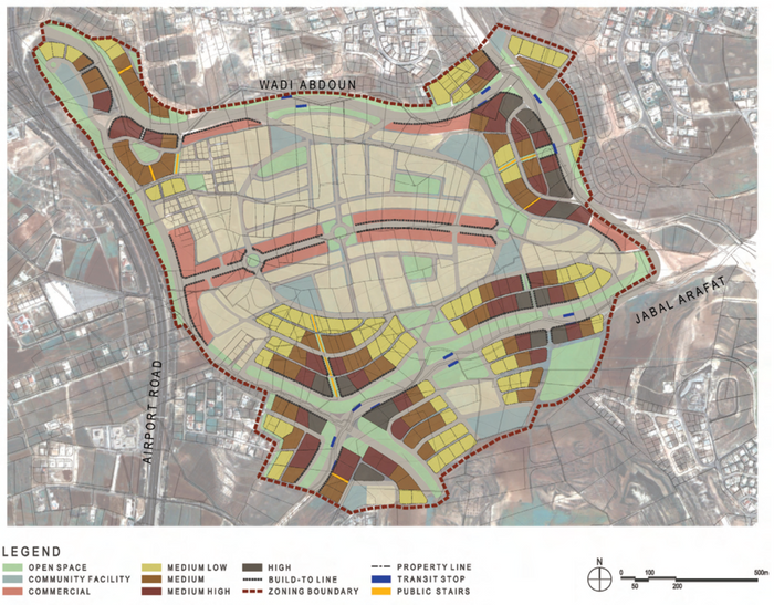
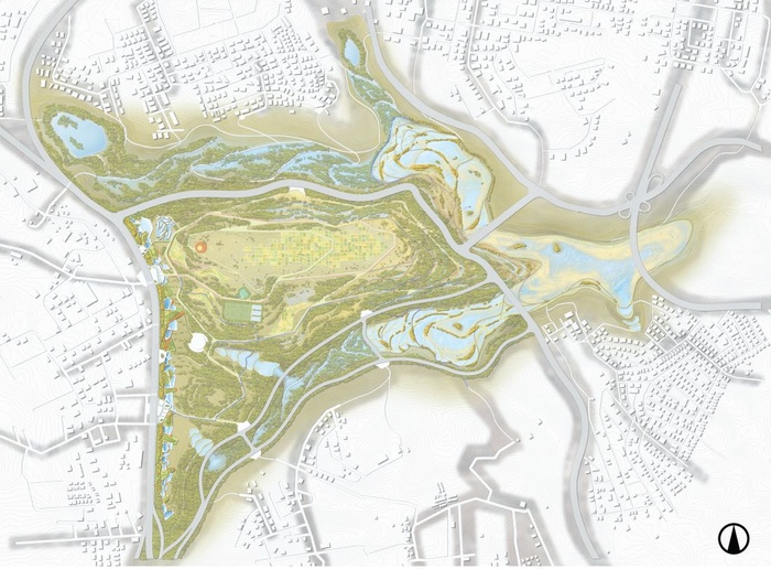
Our proposal re-imagines the municipal master plan (GAM 2025) by envisioning Area C as a regional park, that operates towards a productive water infrastructure to contribute to the water supply of Amman as well as to prevent future floods in downtown. With this proposal, we create a different model of urbanism that prioritizes on a hydrological and ecological system to enact resilient urban infrastructure networks. Through a unified network of silt dams that will catch and hold water, future flash floods and water scarcity will be diverted and alleviated.
Overall Design Strategy
Through our four phase implementation plan, this proposal creates an ecology driven regional park based on water catchment, that proposes an inclusive relationship between urban settlements and its surrounding environment.
Vision
What is Area C and how does it Relate to a Wrong Development Mode in Amman? (Past and Present)
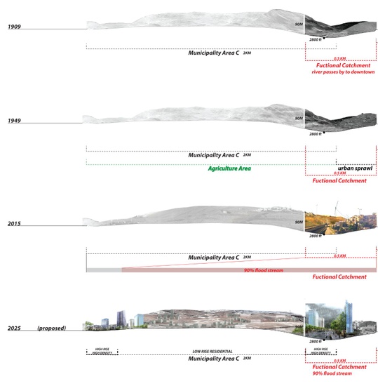
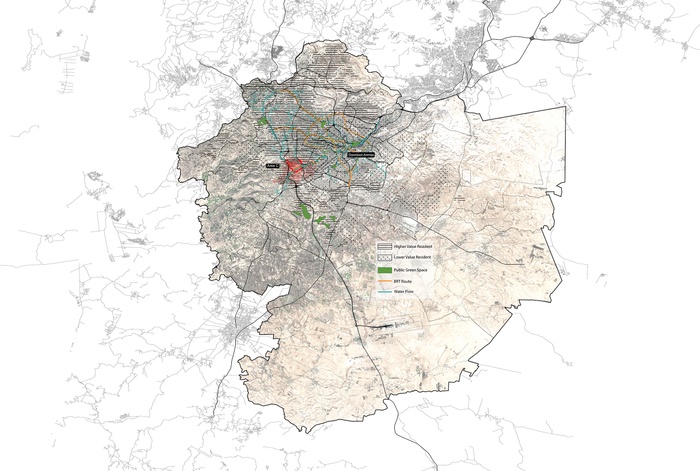
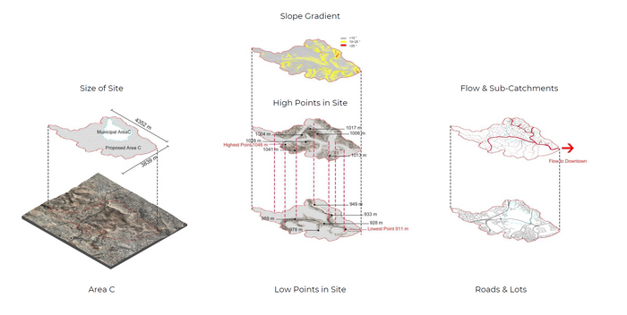
Area C is located upstream from downtown Amman and is one of the last undeveloped stretches of land within the city. It is surrounded by a dense pattern of mostly high end residential developments. Logically, Area C is to be transformed into a high end residential neighborhood as well, ignoring its ecological assets, such as its its fertile ground, capable to absorb and filter water easily.
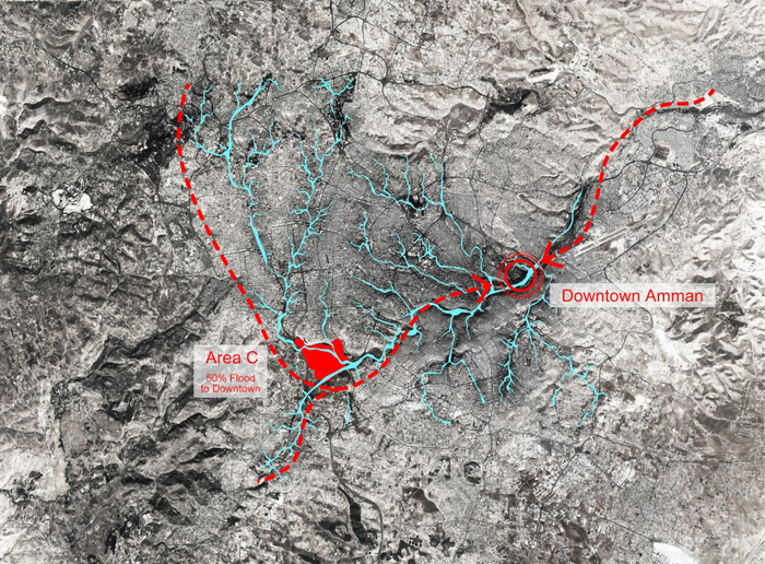
Over 50% flood would pass through Area C to Downtown Amman


Valleys, roads & flows
Relatively better ecological conditions
Strip fields & farmers house
Due to a high influx of people moving to Amman within the past decades, the city has expanded in rapid ways, which resulted in often seemingly uncoordinated growth patterns.
Sections
As the city of Amman is built on a mountainous topography, it provides great advantages to catch water.
The road infrastructure proposed by the city indicates no alignment to the existing topography, which obstructs the natural flow of water. As a consequence the building typology as well does not adhere to the existing topography.
Existing mode ignoring hydralogical and ecological conditions
What are the opportunities in Area C?
Area C is the last piece of land left in Amman without any urban development. Due to its geographical and hydrological condition, the area itself could serve as a catchment that is able to collect 90% of the water from rain. This makes Area C very relevant to downtown Amman as 50% of the water heading towards downtown will pass directly through this area.
Area C development in last 1000 years
However, the Master Plan, issued by the municipality of Amman (GAM 2025), indicates Area C will be developed in the same fashion as other areas in the city without considering the ecological impact this new development will have on the city.
GAM Masterplan 1
GAM imagination vs. reality 2
This proposal does not address possible ecological and hydrological opportunities that would also benefit downtown Amman. By implementing a regional park that also functions as a water catchment area, Area C could not only provide a possible relief for the occurring floods taking place in downtown, but may also serve as a public amenity for the citizens of Amman.
Lack of public spaces in Amman
Area C context
Axo
Area C is composed of several hills and two major wadis. The slope gradient between the wadis varies mostly between 10 to 25 degree. The water flows mainly through these two wadis towards downtown.
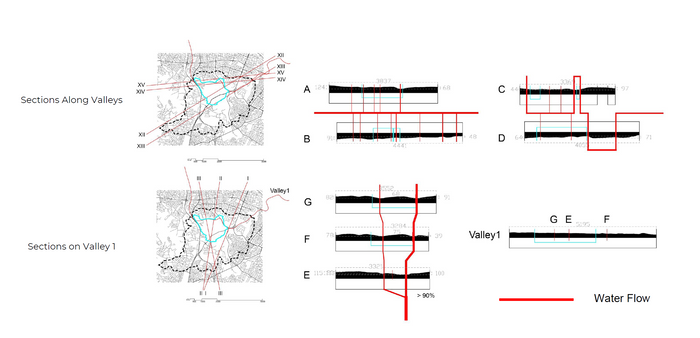
As the sections along the valleys shows, several smaller water flows come down from the hills and join the main wadi towards the two valleys. Among these two valleys, the northern valley bears about 90% of the water flow crossing Area C.
Proposal
Our proposal revolves around a regional park that operates as a productive water infrastructure, supplying the city of Amman with additional water.
Implemental plan
Overall design phasing
Phase one : Relocating municipal roads
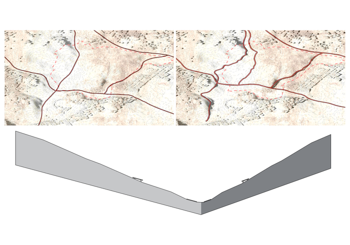
Current roads are located at the lowest points of both valleys, which make them vulnerable to flooding. In order to reduce congestion during the rainy season as well as to further free the topography from obstructing road infrastructures, we propose to relocate these municipal roads to higher grounds .
Phase two : Building water infrastructure
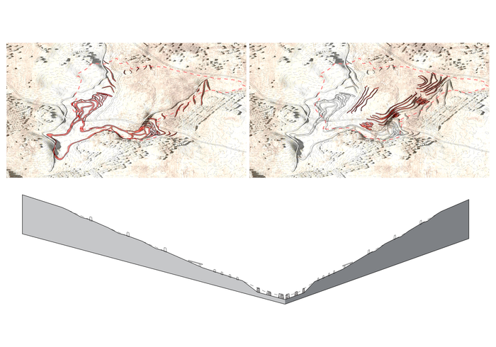
Based on the existing topography, a series of dams, varied in size are built along the valleys- mostly where major surface runoff will pass through. Dams located at higher grounds are positioned to slow down the flow of water, so the soil can absorb the water downstream without being flushed away. Through a careful placed system of dams the water will then be filtered until it arrives at the ponds, located at the lowest point within Area C.
The capacity of the proposed water infrastructure installed is vast. In case of a 100-year flood, more than 67% of the water could be held in the proposed ponds.
Phase three : Recovering ecology
As the water will be held in the ponds a variety of plants may grow here. In addition, the soil is quite fertile, making a wider range of plant growth possible. Eventually, a great variety of species will establish itself here.


Phase four : Park operation overlayed with biodiversity
Phase four : Park operation overlayed with open space
As the new ecology unfolds, wild life will again inhabit this area, such as birds, insects and small sized mammals.
In addition, we propose an education trail that will showcase the water-cycle as part of the pedestrian circulation flow.
Site One
Education trial overlayed with water infrastructure
The above image illustrates a node along the trail, showing how the water infrastructure is slowing down the water flow.
Site Two
Water filtration system overlaid with public space
The above image illustrates a node at the edge of national park, showing how the water infrastructure overlaid with public space is connecting nearby communities and park.
1 The Amman Plan Metropolitan Growth Report by Greater Amman Municipality, May 2008
2 The Amman Plan Metropolitan Growth Report by Greater Amman Municipality, May 2008
7
WatershARed
Students: Jianwei Li, Shuting Han, Yinzhu Shen, Yicheng Xu
What if the fragmented water system in Amman were being transformed into a collective water network through a top-down and bottom-up intervention to re-calibrate the water inequity in the city?
Watershared
Over the past 50 years, Jordan’s population has increased 15 times. In addition, the number of rainy days has decreased by 3-10%. Jordan has built a series of expansive, and high energy-consumption nation-scale water infrastructures, such as Disi Aquifer and King Abdullah Canal to cope with population growth. However, the majority of people still do not have access to sufficient amount of clean water through the municipal water distribution network in Amman.
People’s unbalanced income, as well as the rationing of water supply and commodification of water has resulted in water inequity throughout the city. To recalibrate water inequity in the city, WATERSHARED, converts the water system in downtown Amman from an individual to a collective water network through top-down and bottom-up interventions.


Al Kalaa
Water Tank
Stairs
Pipes
Abandoned House
The rationing water system and water inequity
In Amman, the Jordan Water Authority(WAJ) rations the water supply. Each household receives only 24-72 hours of municipal water supply per week according to the location of neighborhoods. Everyone in the city needs to purchase additional water as WAJ is not supplying enough water.
Rationing Water system
During the 24-72 hours supply time, people need to fill in their water storage facility (bought by themselves), such as a tank located in the basement. Once they run out of the water, they need to call expensive private water trucks to get refills. If the truck is not available, they have to buy bottled water, which is ten times more expensive. Water is regarded as a commodity instead of necessity. In this case, the more affluent citizens have more access to water resources, which leads to water inequity in the city, especially for people living in downtown Amman, who are suffering from both water shortage and periodic flash flooding.


Water Inequity - Building
Um Uthaina
Abdoun
Jabal Amman
Al Wehdat Refugee Camp
In Amman, most of the upper and middle class live in the west, consuming much more municipal water than the lower class as well as the refugees living in the east. This spatial differentiation is closely related to access of water, purchasing power, storage capacities, water usage and attitude towards water. This kind of rationing of water supply causes very different living conditions and lifestyles between the rich and the poor. For example, the upper class living in Abdoun can afford to have swimming pools while people living in downtown Amman may just have 2 cubic meter water storage for an eight-member family.


Water Inequity - Household
Um Uthaina
Abdoun
Jabal Al Kalaa
Al Wehdat Refugee Camp
Downtown Amman context
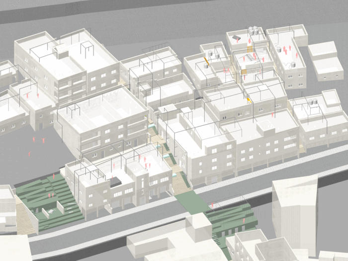
Downtown Amman, which is one of the oldest districts in the city, located on one of the seven hills is where most of the commercial activities are concentrated. It is also an area where the less affluent people of Amman live. Local buildings are constructed along the hills from top to bottom and are vertically divided into three segments, connected by a network of staircases.
The upper part of the district, the residential segment, is where the low-income class and the refugees live. These people have very limited access to water and storage facilities. The middle part consists of offices, a clinic and a hotel. The lower area houses local retail stores, traditional souks and restaurants with a high water consumption for washing and cleaning.
7 hills of Downtown Amman


Site Context
Social Composition
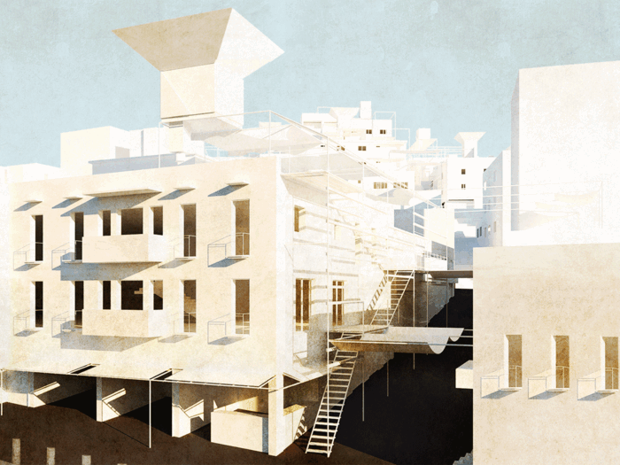
Water infrastructure renovation strategy to empower people We identified four kinds of untapped urban infrastructures: water tanks, exposed pipes, staircases, as well as abandoned houses.
In our proposal, the roof is used for collective municipal water tanks and portable water filter. The facade is used for greywater filtration. The staircase is excavated for both channeling and holding rainwater. The abandoned house is transformed into a greywater station.
Greywater will be gathered from each household. Based on the geographic location and its treatment via the facade and staircase, the filtered water will flows into the nearest greywater station.


Collective Water Tank
Filter Wall
Stairs as Water Channel
Abandoned House as Grey Water Station
Design intervention for the new water system
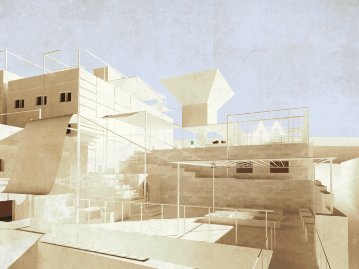
During dry season, municipal water supply comes to the roof to fill the new collective water tank. Other water supply flows down to the household for the domestic water usage. The greywater would be collected from the kitchen and bathrooms and then flow to the filtration network on the facade, passing the new staircase water channel, towards the greywater station, which will then cycle back to the neighborhoods or sold to the commercial buildings. Residents in the upper districts may use these funds to construct new infrastructures for the upper area. During the rainy season, The holding space on the staircase can hold and slow the water flow. The water channel can direct rainwater to another water station for storage.
Water Flow Unit - Dry & Wet

Water Flow Diagram
Intervention Network testing in site
To test our intervention, we zoom into the densest area of downtown Amman. As a first step, the proposed collective water unit will form, based on their kitchen bathroom, proximity to the staircase, and connections to other neighbors. Due to the topography and proximity to the staircase, we propose each family shares their tanks with adjacent neighbors in order to increase their water capacity.


Collective Water Unit
Municipal Water Distribution Network
In the rainy season, we imagine the rainwater holding space and green space to be integrated into the stair as a water detention network.


Greywater Accumulation Network
Rainwater Holding Network
Section
Overall design phasing
Exterior space and interior water-related space, such as bathroom and kitchen are regarded as a holistic water infrastructure. According to phasing, the basic water infrastructure gradually creates space that caters to the residents daily life and water needs.
In phase one, the local residents can collect the existing water tanks and organize them into a lift-up platform. Also, water pipes from the platform will direct water supply to rooftops and interior spaces. The municipality will fund local residents to build up a new water network on their rooftop. NGO’s, such as Wise Water Woman will support the locals in this effort.
At the same time, the rainwater holding space and green space will be added on the staircase, the abandoned house will become an active storage facility to hold the greywater from neighboring households. These groundworks are executed by the municipality.
In phase two, the local citizens will implement larger collective water tanks to replace the old tanks with funds provided by the municipality. More households nearby can also participate in these shared water units by connecting their pipes to the network.
These water pipe networks will grow gradually and contribute to the transformation of the roofscape. By adding additional structures and shading by the locals onto the main structure, new spaces are being created, adding new layers to the overall network.
In phase three, the intervention revolving around the staircases is completed by the municipality. Greywater that comes from the kitchen and bathrooms can be connected to the bio-filter which also can provide the cooling environment and green area along the stair. In addition, local residents can add water filters to the new water tanks. The newly created space along the staircases provides additional gathering spaces for the residents as they keep constructing and using their roof space. The roofs are connected by ramps to create a new circulation pattern for water-related community activities such as cooking, praying, gardening and community workshops.
Phasing of Axonometric Drawing
3 Scale Scenarios
New water tanks and structures provide water supply for the local residents, and gradually reactivate the roof space as a social condenser with different programs, such as cooking, praying and family activities.
Roof Scale Scenario
The collective water systems also reframe the network of the roofs, staircases, alleys and roads to change the fragment urban condition as a dynamic space for locals to explore more water-related activities to empower the community.

Stair Scale Scenario
Zooming out to the whole site, we envision this infrastructure network to become a holistic water based infrastructure that alleviates water inequality for everyone.
Street Scale Scenario
Future Vision
Since the intervention includes creating new collective water tanks on the rooftops with a rainwater collection system, greywater filtration, and rainwater holding and runoff areas, this project empowers the local inhabitants of downtown Amman to build micro-water infrastructures, as well as communal gathering spaces and thus enhances the livelihood of a community at large.
Vision
Project Video
End
Acknowledgements
Publishing By:
Columbia University Graduate School of Architecture, Planning and Preservation Urban Design Program 411 Avery Hall, 1172 Amsterdam Avenue New York, NY 10027 United States of America
Columbia Faculty
Kate Orff, Dilip da Cunha, Geeta Mehta, Julia Watson (Aqaba Site Faculty: Ziad Jamaleddine, Nora Akawi, Petra Kempf, Laura Kurgan)
Roving Engineer: Jason Loiselle
Columbia University Students
Amman
C for Catchment
Chenyu Xu, Duolin Kong, Keli Wang, Stanley Zhang
Watershared
Shuting Han, Jianwei Li, Yicheng Xu, Yinzhu Shen
Aqaba
Wadi [Re] Urbanization
Jack Bai, Betsy Daniel, Ken Piyawut, Janki Shah
Aqaba 2.0 Solar Souk
EJ Hu, Xing Wang, Ke Ren, Sonu Sharma
Fan Urbanism
Leslie Chuang, Tian Guo, Wan-Ting Tsai, Guan Wang
Reclaiming the Gulf
Jose Neto, Meng Li, One Lee, Noor Malik
Unbuilding and Repurposing a SEZ
Deeksha Kalra, Linda Schilling, Niharika Kannan
Special Advisors
Arch. Jawad Dukhgan
With special thanks to
Arch. Ammar Khammash
Collaborations
Studio X, Amman
Columbia Global Centers
Student Collaborations
Sarah Makahleh, Tamara Murad, Hannan Kataw, Leen Qudah
Curated and managed by:
Ban Edilbi, Jesse Hirakawa, Niharika Kannan
Copyright © 2018, The Trustees of Columbia University in the City of New York. All Rights reserved. No part of this publication may be reproduced or transmitted in any form or by any means, electronic or mechanical, including photocopying, recording, or information storage or retrieval, without permission from the publisher.