
“Water is life. It’s the briny broth of our origins, the pounding circulatory system of the world…”
—Barbara Kingsolver, Fresh Water, 2010
Foreword
Water Urbanism
The Urban Design Program at Columbia GSAPP is investigating climate response at multiple scales and collaborating with partners in institutions around the world and within the University from science & engineering, journalism, conflict resolution, economics and social justice. We aim to marshal the observations of the world’s best scientists and the agency of design toward action and defined, replicable climate adaptation projects in the world’s most vulnerable regions. We bring synthetic design thinking to this process and a stance of activism and engagement and believe that by building physical, resilient places we engage and educate communities about the risks they face. Kolkata, India is a coastal global megacity experiencing the effects of climate change with millions of lives and livelihoods at risk from inundation, increased rainfall, groundwater extraction, water quality, and rising temperatures. How we live with - and design for- water will be a central, defining element of the next century relative to climate change and urbanism.
Water is constantly in motion, changing states, crossing borders, nourishing (and destroying) life. How can water and urbanism be considered together as a generative frame for urban design practice, social life, and ecological regeneration? The spring semester 2017 design studio investigated urbanization challenges in two regions with robust ecological contexts, intense migration, resource conflicts, and urban growth trajectories: Amman and the Lower Jordan River Valley, and Kolkata, India and the Sundarbans tidal mangrove forest. In both cases, the studio explored the dynamics of climate adaptation relative to migration and climate change, alongside the generation of new social infrastructure, public space and urban design in an expanded rural-urban context. The seven projects represented in this volume operate at multiple scales, linking territorial independencies, to operational landscapes, to pilot sites of detailed investigation for design exploration and on-the ground change.
Columbia UD Faculty: Kate Orff (studio coordinator), Nora Akawi, Dilip DaCunha, Ziad Jamaleddine, Petra Kempf, Laura Kurgan, Geeta Mehta, Julia Watson
Special thanks to Prof. Joy Sen Professor and Head, Ranbir and Chitra Gupta School of Infrastructure Design and Management and team, IIT Kharagpur.
INTRODUCTION
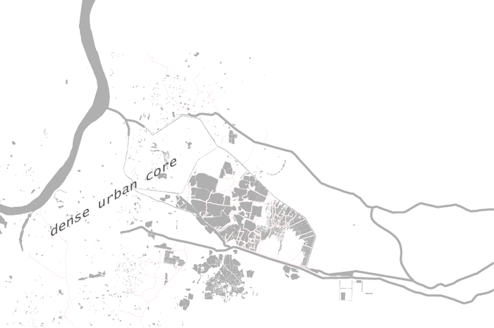
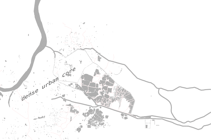
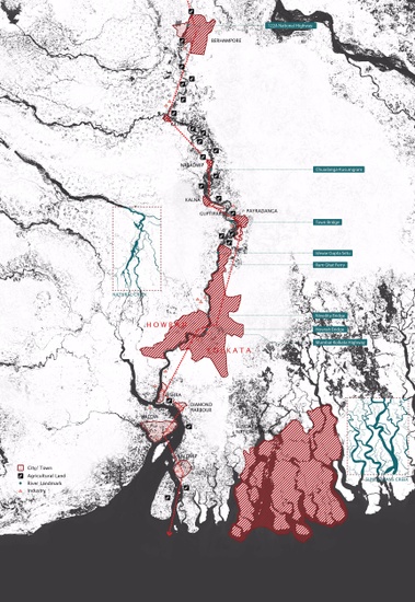
Kolkata & The Sundarbans
How can Kolkata, a city of nearly 5 million people, adapt to rising sea levels and extreme weather? Kolkata’s urbanization process is inextricably linked to the larger regional ecosystem of the Sundarbans, a UNESCO World Heritage site located in the Indian state of West Bengal and in Southern Bangladesh. Covering about 4,000 square miles, the Sundarbans is a zone of exceptional biodiversity and one of the largest tidal mangrove forests in the world. It serves as a protective shield against cyclones and tsunamis for a densely populated area further inland. An intricate network of tidal waterways, mudflats and small islands makes almost every corner of the forest accessible by boat. However, this protective ecosystem is imperiled by constant threat from coastal erosion, sea level rise, and salinization and is estimated to have dwindled to 1/3 its size since it was last measured 200 years ago. It is also increasingly threatened by the growing pressures of development, unsustainable agriculture and industrial aquaculture. Moreover, the East Kolkata wetlands has served as a massive nature-based sewage treatment system of Kolkata for centuries, but this productive agricultural landscape is under stress due to increasing population and pollution. Within this watery context, the studio explored territorial strategies for the region in parallel with a focus on specific sites in Kolkata along the Hooghly River. Student projects aim to discover: how can the Sundarbans and Kolkata be considered together ecologically and economically? How can wetlands be re-valued? How can ritual be tied to ecological regeneration? How can we foster next century economy for Kolkata that is sustainable and adaptive? Our urban design investigation of the Sundarbans and Hooghly context aims to make communities in these settings economically, ecologically and socially more resilient to natural calamities and manmade hazards.
Water and Social Equity in Kolkata
Geeta Mehta
Kolkata is a water rich city. However, the scarcity of potable water for its poor, and life threatening seawater rise and storm surges for those who live along the waterways and coastal areas, make water the best lens for understanding and addressing the social inequities of this region.
While life expectancy in India rose from 41 to 68 years between the years 1960 - 2015, it has actually fallen for people below the poverty line ($1.90/day) who account for 21% of India’s population.1 While the rich in India are beginning to enjoy the fruits of rapid economic development and first world luxuries, the falling life expectancy for the poor is due to inadequate health care and basic infrastructure such as clean drinking water and sanitation. Even as the income inequity in India is growing and a cause for alarm, inequity in access to clean drinking water and clean air is absolutely unacceptable, and correcting that should be among the highest priorities for the government, academia, industry and community stake holders.
Water inequity affects the poor in Kolkata in two ways. While piped water of reasonable quality reaches the wealthier neighborhoods, poorer neighborhoods often get just a few hours of water on public taps, and rely on water tankers that charge heavily for providing additional water. Secondly, most poor neighborhoods are situated in flood prone areas in the city. This geographical inequity in Kolkata has been increasing due to lack of understanding and respect for the historic network of creeks and “pukur” tanks that drained neighborhoods while also holding water for use in urban agriculture and fishing. Development pressures have resulted in filling up of these water bodies, while the social system that helped maintain these community assets has disintegrated in the face of the government claiming ownership of this task and subsequent disenfranchising of the poor people who lived around these water bodies. Water spaces were also the social spaces for these neighborhoods. The loss of these is resulting in the depletion of social capital that held communities together. However, since there is no system at present to measure and value social capital, the government does not take this into account in its decisions. 2
Poor people living along the Hooghly River or the coast face increasing threats from seawater rise and storm surges, but do not have an option to move elsewhere as most new developments built or subsidized by the government are for the middle and high-income people, even as the unfulfilled demand for ultra low income rental housing hovers around 90%. With alarming vacancy rates since its building, Kolkata New Town, built as a dream city for the middle income people, is a good example of such misallocation for public funds which are driven to generate large profits for the builders and governments, rather than to address social needs and build social capital. New migrants into Kolkata have no social support except from what they can get from friends and family. Those that arrive without such support with the intention of earning a living for themselves as well as their families they leave behind in rural areas often end up sleeping on the sidewalks or railway stations. In the words of development economists Amartya Sen and Jean Drez such social inequity “keeps a majority of Indians shackled to their deprived lives in a way quite rarely seen in other self-respecting countries that are trying to move ahead in the world.” 3 What difference does it make, the authors ask, to lift millions above some notional poverty line if they still lack the basics of a decent life?
The fact that East Kolkata Wetlands have been shrinking despite being declared a RAMSAR site is evidence that the government has become a monetizer of land instead of protector of the social and ecological justice. Shrinking of the wetlands will also result in intergenerational inequity. While the government in Kolkata has promised to build new sewage treatment plants to deal with the growing population, future generations will not have the Wetlands as the green lungs of the city while also treating sewage, producing 80% of the city’s vegetables and 50% of its fish. Long-term detriment to the sustainability of the Wetlands will far outweigh the short-term profit to the developers and builders who are being allowed development rights over this precious asset of the city.
Nothing speaks louder for the extreme social inequity than bottled water use in Kolkata. Heavy advertising touts the purity of bottled water compared to contaminated tap water, resulting in skyrocketing increase in its use.4 However, the use of bottled water by wealthier people takes that influential group away from demanding that tap water be uncontaminated and healthy for every one. In addition, the clogging of waterways and dumpsites, and burning of used water bottles at recycling villages by scavengers to retrieve plastic damages the health of the poor, reducing their chances of climbing out of poverty.
According to Charles Fishman, diarrhea caused by tainted water shaves off 2% of India’s GDP, about $20 billion every year,5 while the need to constantly fetch water from tankers or from sometimes putrid wells assures that a good portion of the population, particularly India’s women, will remain uneducated and often illiterate. Water poverty is, quite literally, de-civilizing.
So what is the solution? It is to demand from, and enable the government to look at development through the lens of water. All stake holders, and the academia has a role to play in this. Tap water for all must be adequate and healthy. Money is not a problem in India, political priorities are. Clean water should be added to the Swatch Bharat (clean India) campaign being promoted by Prime Minister Modi. Building developers in India make 200 - 400% profit on the housing they build for middle and high-income people. This is in multiples of such profit in any other country because the Indian government does not demand any infrastructure of social good in return for giving away development rights over public land or rezoning farmland. Every new for-profit development could be coupled with an informal or coastal settlement of poor people, to be improved before work begins on the for-profit development. Such improvements should include water supply and sanitation infrastructure, affordable housing and public spaces. Affordable micro housing should also be mandated in new housing developments, so the city does not get fragmented among the rich and the poor, who in fact depend upon each other. The social capital this will help save, and generate, can in fact be measured in lives saved in coastal areas every monsoon season, decrease in disease, and well being of the citizens the current political system does not adequately serve, and on whose back the current economic boom is riding.
Map Action
Laura Kurgan, Grga Basic
A series of mapping workshops was interspersed and linked to the studio pedagogy throughout the semester. Maps are not neutral objects, they hold political and social data and formulate arguments by layering diverse types of information onto one image. Maps can visualize the invisible by helping a user to navigate toward unexplored landscapes and places; but maps can also normalize a speculative project because in the end most people think that maps are true. There are many shades of grey between these two positions – invisibility and speculation.
Deeply aware of how mapping builds arguments and makes claims, the work we asked students to do, actively experimented with these extremes with specific relevance to Water Urbanism.
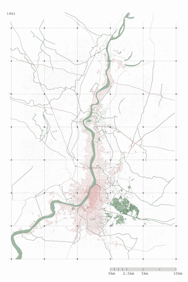
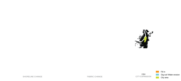
Urban Growth of Kolkata 1961-2017 (Nabi Agzamov)
Tracing the transformation of land cover patterns and urbanization over time has been critical in our discussions. One of the most important applications of remote sensing is land use/land cover change mapping. The availability of free landsat satellite images that have been in orbit since 1972 has made it possible for us to map land cover at different spatial and temporal scales and to create quantitative analysis of land cover changes at multiple time increments. We challenged the students to interpret the ground condition, and to speculate and recognize how changes of certain features on the ground lend themselves to a story of the process of urbanization and lead to a variety of design responses.
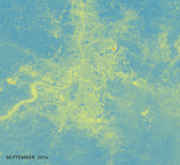
Using the Landsat 8 Coastal Aerosol Band, this change map shows the concentration of aerosols in the atmosphere during and post monsoon season (Evelina Shih Knodel)
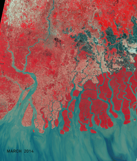
Intensity of the red shows changes in vegetative growth across seasons in the Sundarbans region using Landsat 8 false color imagery
http://data.worldbank.org/indicator/SP.DYN.LE00.IN?yearlowdesc=false
Geeta Mehta, The Smartness of User Generated Cities a+u 2014:11, October 2014
Jean Drèze and Amartya Sen “An Uncertain Glory: India and Its Contradictions”. Princeton University Press. 2013
Peter Gleick, “Bottled and Sold: The Story Behind Our Obsession with Bottled Water” (Island Press), 2010
Charles Fishman, The Big Thirst — The Secret Life and Turbulent Future of Water (Free Press), 2011
1
Re[de]fining Monumentality
Students: Chris Chiou, Grace Ng, Mario Ulloa, Kristen Reardon
What if monuments looked beyond colonial histories, towards an ecologically-resilient future?
mon·u·ment: /ˈmänyəmənt/ (noun): A statue, building, or other structure erected to commemorate a famous or notable person or event.
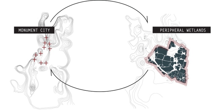
The project’s vision is to redefine and reappropriate the notion of monumentality in post-colonial Kolkata. It seeks to establish a reciprocity between the past and the future, across the central highlands and the peripheral lowlands, activating cultural capital against current hegemonic injustices. Re[de]fining Monumentality establishes a levelling within traditional architectural/urban understandings, to allow for empowerment that syngerzies historic preservation and ecological conservation.
![Monumentality Re[de]fined: the edge strikes back](https://d37vpt3xizf75m.cloudfront.net/api/file/d7tEvTrIRL2efbdrisGO/convert?fit=max&h=550&w=700&compress=true&fit=max)
Monumentality Re[de]fined: the edge strikes back
Calcutta vs Kolkata: A Tale of Two Cities

Princep Ghat vs Prinsep Monument: dissonant homophones
What is the paradigm of monumentality in Kolkata?
Within the floodsafe highlands of the city, monuments commemorate a singular history: the British colonial rule. Dispersed around the central core, their pristine neoclassical aesthetics stand out amongst the contextual urban grit and hyperdensity of Kolkata. These occupy privileged grounds and remain as manicured areas that are contextually unadaptable and consistently underutilized.
In contrast, the designation of the peripheral low grounds, East Kolkata Wetlands as a RAMSAR site of international importance, presents a monumental landscape of infrastructural productivity. Its generative ecology treats excess sewage from the city and simultaneously acts as flood defense, world-renowned as a pioneering system. Yet, its conservation faces serious threats from urban encroachment.
Together, the dialectic between the high/low lands and the urban center/edge dynamic produces an uneven post-colonial cultural landscape rooted in physical topography.
Kolkata’s core is interpersed with colonial monuments constructed during the British Rule and British Raj, featuring distinctly neoclassical forms and materialities. A cumulation of Corinthian columns, Baroque fountains, Indo-Saracenic palaces, Gothic churches amongst statues, monoliths, mounds, obelisks, together become landmarks paying homage to British legacy. In addition, such monuments are accompanied by formally landscaped lawns and ornamental gardening. These colonial monuments have become the common, narrow understanding of built heritage within West Bengal, being stringently regulated and kept immaculate by the government.
At the eastern peripheries of Kolkata, the wetlands represent an ecological treasure providing an invaluable service to the city. A hodgepodge of anaerobic, facultative and maturation ponds, mostly run by local Bheris, have the capacity of converting sewage to clean water through garbage-fed fish farming. This closed system recycles waste into fresh agriculture, affording economic independence to local communities who depend on produce for their sustenance and livelihoods. Saturated with biodiversity, the rich landscape is also a place of respite away from the hustle and bustle of the city, becoming the center for nature-centric and educational activities.
[De]centering the city: Forefronting the East Kolkata Wetlands
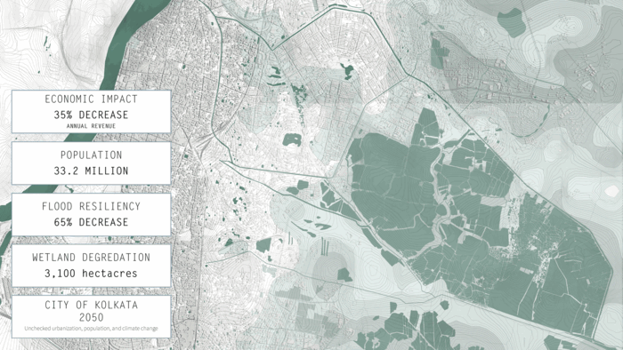
Shrinking Wetlands: Impact of Ecological Loss
Problem Statement
Kolkata 2050 faces acute challenges of sea level rise and erratic rainfall. If unprotected, the continually shrinking East Kolkata Wetlands will be compounded by a population boom causing severe flood hazards.
[Re]conciling the center+edge: From Singularities to Mutuality
Conceptual Framework: reciprocity across cultural+physical topographies
mon·u·ment /ˈmänyəmənt/ (noun): A performative marker within a resilient landscape.
Our two-pronged design intervention seeks to establish reciprocity within the colonial center monuments whilst monumentalizing the edge wetlands for the future resiliency of Kolkata 2050. By redefining the notion of monumentality through a system of strategic co-location, the monument now represents both a productive and valued form of resiliency.
SITE I:
[Re]claiming The Colonial Center
The Shaheed Minar was erected in 1828 originally as the Ochterlony Monument, after the commander of the British East India Company. It memorialized the successful defense of Delhi against the Marathas in 1804 and the victory of the East India Company’s armed forces over the Gurkhas in the Anglo-Nepalese War. In August 1969, it was rededicated to the memory of the martyrs of the Indian freedom movement by the then United Front Government, being renamed the Shaheed Minar which translates to Martyrs’ Monument in Bengali and Hindi, reclaiming the narrative of the monument. Nested within an open lawn known as the Brigade Ground, it has also been the site of colonial resistance: Rabindranath Tagore once rallied against the British, to condemn the killing of a youth in Hijli during 1931.


Shaheed Minar - monsoon configuration: elevated platform for flood resiliency
Shaheed Minar - festivity configuration: vibrant economies and entertainment
Shaheed Minar - daily configuration: an accessible community recreation hub
Techniques of cut and fill are implemented at a site scale to enhance resiliency and flood drainage, whilst hard edges such as boundary fences have been replaced with porous, soft landscape strategies. Together, they allow the colonial monument highlands to be optimally accessed during various temporalities:
1. DAILY: recreational maidan + transport hub
With an expanded 10 m street access and a retrofitted bus depot for central Kolkata that accomodates up to 140 buses, traffic circulation has been engineered for optimal efficiency to prioritize access.
2. FESTIVITY: community gatherings + informal economies
Elevated platform with dedicated space for pop-up street stalls, interspersed with micro-event stages and social gathering seating areas.
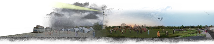
3. EMERGENCY: place of refuge during floods
Provision of temporary shelter with single-family relief tents, accompanied with a full range of facilities that include sanitation, food distribution, communication tower, meeting point, medical aid services.
Infiltration of the permeable wetland edge into the city center
In detail, the retrofitting of colonial monuments focuses on a wetlands-inspired edge planting strategy for optimal permeability and productivity in times of emergency. This softened periphery, by replacing fences with landscaped drainage swales, encourages public access within the underutilized maidan.


Shaheed Minar during emergencies: a space for refuge
Shaheed Minar during festivals: a space for celebration
Shaheed Minar during daily use: a space for gathering
SITE II:
[Re]monumentalizing The Wetlands Edge
Despite being designated as a RAMSAR site of international importance, the East Kolkata Wetlands have consistently and increasingly faced serious threats from real estate pressures. To resist this, the project draws upon the cultural capital and valued traditions associated with Monumentality, in order to diametrically oppose the capitalistic quantification of land.
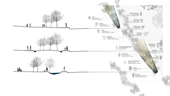
The Durga Puja is an annual ten-day Hindu festival celebrating the victory of Good over Evil, a harvest festival worshipping goddess Durga as the motherly power behind all of life and creation. It is observed in the Hindu calendar of Ashvin, typically September or October of the Gregorian calendar. Integral to the West Bengalese identity, the multi-day festival showcases elaborate handcrafted temporary temple and stage decor pandals, along with street parties, performance arts, revelry and processions. On the last day, Vijaya Dasami, Durga Puja idols are ceremoniously marched to the sacred river Hooghly of the Ganges for a holy immersion ritual.
RAMSAR route: Sowing Seeds of Change
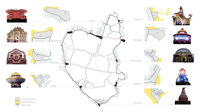
Through the festivities of Durga Puja, our proposal hopes to create a ritualistic wetlands landscape to bring the East Kolkata Wetlands ecological backdrop to the forefront of the city’s cultural identity. Inspired by the 9 forms of the goddess Durga, 9 sites have been selected as seeds of change, locating interspersed towers that are premised on community-specific custodianship, collectively demarcating a protective limit against urban encroachment.


Sector V site during daily use: community hub for productivity and sustenance
Sector V site during monsoon: flood inundation as defense
Sector V site during festivals: point of interest and activity hub
Zooming in, each site features a permeable edge strategy that allows for water to infiltrate and expand beyond each demarcated pond. The new peripheries act as fissures that function as flood remediatory systems through drainage and inundation.
1. DAILY: agricultural cropspace
Each site has a specific crop space corresponding to one of the 9 Durga Puja plant species, complemented by irrigation channels that total up to an area of 11,054 m2. Community spaces act as programamtic anchor, in the form of a 1,500-capacity amphitheatre for social gatherings.
2. FESTIVITY: community gatherings + informal economies
Post-harvest seasonality leaves behind empty agricultural land that can be temporarily converted to accomodate pedestrian, crowd, economic, and vehicular spillover and capacity expansion.
3. EMERGENCY: inundation and flood defense for Kolkata
Detention ponds with a total capacity of 8,102 m2 minimize damages to surrounding living areas as well as the city, holding overflow water.


Axonometric: Bio-reactor tower featuring pandal structure
Section: Bio-reactor program locations
Section: Bio-reactor flood resilience
Section: Bio-reactor vermifiltration process
Each tower showcases the vermifiltration capacities unique to the East Kolkata Wetlands and acts as an elevated refuge space from floods. Programmatically, they house festival preparation activities during the rest of the year, allowing for the provision of local livelihoods.


East Kolkata Wetlands during emergencies: protection from flood inundation
East Kolkata Wetlands during festivities: centerstage of Durga Puja
East Kolkata Wetlands during daily use: a ritualistic and celebratory landscape

Monumentality: From 1690 to 2050
![Monumentality Re[de]fined: the edge strikes back](https://d37vpt3xizf75m.cloudfront.net/api/file/VeMFlQKuThiTWqRmTwJh/convert?fit=max&h=550&w=700&compress=true&fit=max)
Monumentality Re[de]fined: the edge strikes back
Kolkata 2050 presents an opportunity to (re)define and (re)center itself. As a post-colonial city, the notion of monumentality will be expanded, encompassing beyond a singular British ruling history but also towards an ecologically-resilient future.
2
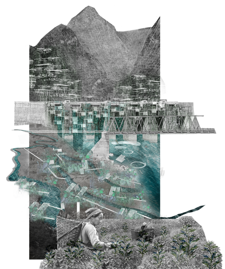
Bengal Flux
Students: Carmelo Ignaccolo, Deniz Onder, Dissa Pidanti Raras
What if the Bengal Area was a ground to accommodate migrant communities (humans, plants, animals) in response to the dynamics of climate change?
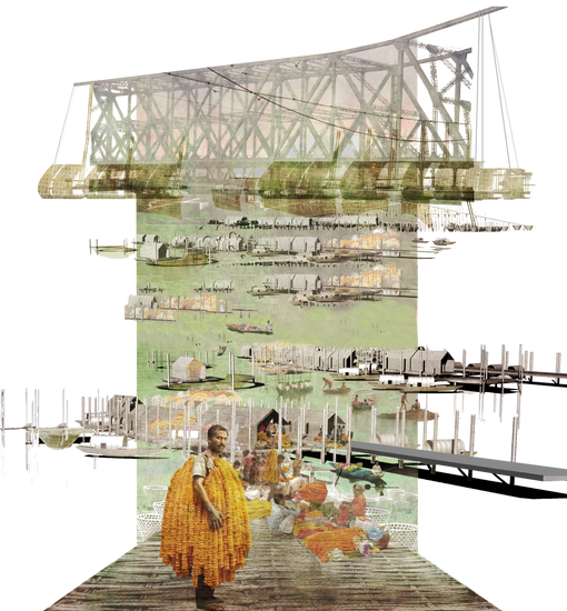
Kolkata Flower Market: floating market & “living” Howrah Bridge
Bengal Flux is a design vision for the Bengal region. It proposes an adaptive infrastructure for migrant ecological communities in the face of climate change. It equips current fixities in the landscape including dams, barrages, bridges, and levees to accommodate the dynamics of soil, fishes, birds and importantly, farmers. Its ultimate objective is to make a ground that embraces uncertainty and complexity.
Learning from Kolkata flower market
The site exploration of the Bengal Flux started in Kolkata where we documented the activities of Malik Ghat Flower Market from 2:00 am till 7:00 pm in different days Kolkata Flower Market. We were particularly impressed by the systemic organization of the coolies (people in charge of transporting goods – specifically flowers) who traveled hours by train from the flower fields to the two main railway stations of Kolkata: Howrah and Sealdah. The flower market became for us a microcosm of the Bengal, with different cultures, people coming from lots of villages located from the Himalayas to the Sundarbans, flowers and products. The interest towards the atavistic fluctuation of this place inspired us to understand the temporality of India and how the landscape is actually changing because of the monsoon season and of climate change.

Monsoon temporality in the Indo-Gangetic plain (August-October-December 2016)
The first analyses were located in four areas of production of different flowers: Sikkim, Patna, Krishnanagar and Panskura.
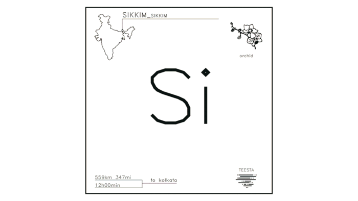
Sikkim, the Zemu Glacier does not have any more perennial ice
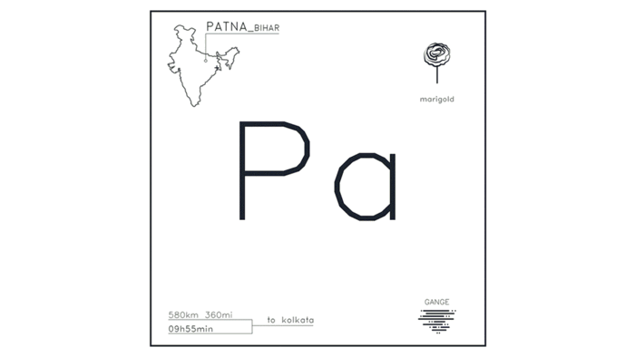
Patna, Ganges River overflow during the monsoon
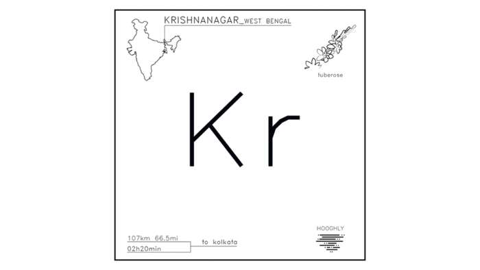
Krishnanagar, crops activation during the rainy season
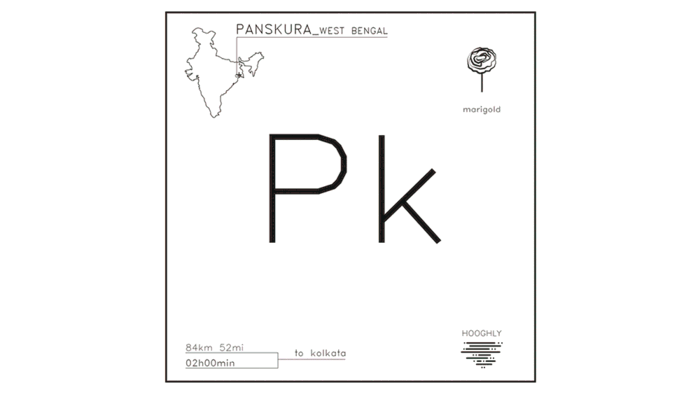
Panskura, rain fed crops and vegetation blooms in the wet season along the water channels
In Patna, the Ganges River overflows during the monsoon season, as showed in the following change map
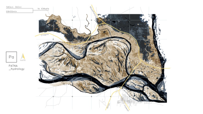
Patna, change map
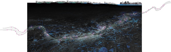
Bengal Transect
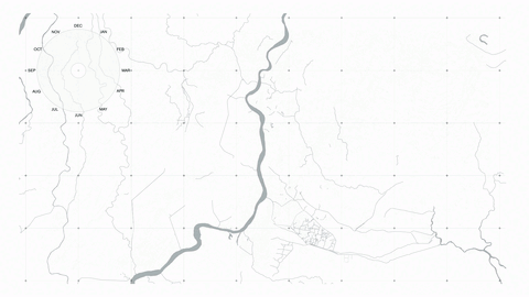
The Bengal region, which extends from the Himalayan Mountains to the Bay of Bengal, is currently one of the most vulnerable areas in the world in the face of climate change.
](https://d37vpt3xizf75m.cloudfront.net/api/file/eqhI5t5Q4iS0JCvWPO9Q/convert?fit=max&h=550&w=700&compress=true&fit=max)
Melting glaciers in the world’s highest range, severe floods in the Ganges-Brahmaputra basin, and sea level rise in the Sundarbans are all exacerbated by deforestation, rapid uncontrolled urbanization, rising population, and one of the highest population concentrations in the world (1.300 inh/km2). Farmers here are forced to migrate to urban centers such as Dhaka and Kolkata in fragile ecosystem of the Bengal delta where cities are already in conflict with non-human species and their migration patterns. These patterns are themselves changing and in dire need of accommodation in the wake of the epochal changes to climate underway.
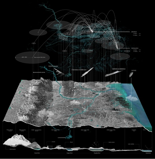
Section from the Tibetan Plateau to the Bay of Bengal, showing displacement, floods, climate change effects and design sites


Rockite and acrylic model of the Himalayan transect
Rockite and acrylic model of the Himalayan transect
We trace these problems to, among other things, the systemic failure of an infrastructure built to fix and control rather than accommodate and negotiate the natural flows and fluctuations of water, land and ecological communities: dams, barrages and levees. These ‘fixities’ built into an atavistic ‘flux’ have caused untold damage and introduced considerable uncertainty. Can design turn this around in an age that is realizing the virtues of uncertainty and complexity; can it contribute to making a landscape that is more accommodating and adaptive?
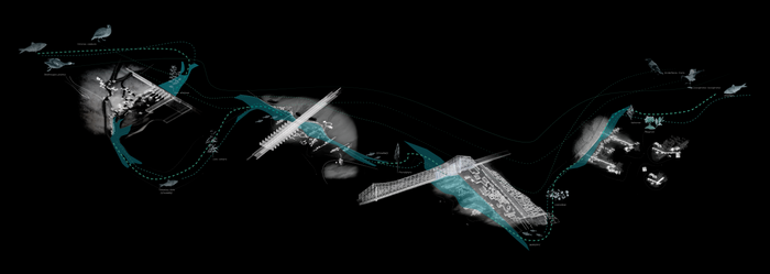
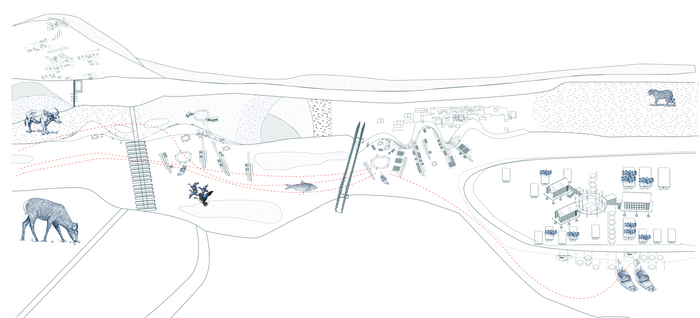
Axons of the design sites (from the left side): Teesta, Farakka, Kolkata, Sundarban
Design Concept
Our design concept is mainly based on four steps: edge, infrastructure, anchor and rhizome. The adaptive infrastructure will gain its independency on the existing anchor (dam, barrage, bridge or levee), becoming a parasite of a new form of urbanization in water. The strong concept of our design is to propose an adaptation to the natural flow of water and ecologies, hacking the infrastructures which used to play a resistance towards that.


Edge
Infrastructure
Anchor
Rhizome
In order to slow down the flow of the water according to the free-flowing river theory, we studied how the speed of the water flow is linked with the shape of the river bank. This study wants to determine the possibility of creation of pockets of ecologies along the river through system of aggregation of the components of our design.

River flows around the “chars” (floodplain sediments)
The material utilized are bricks and bamboo. Both of them are widely available in the entire Bengal area, which is one of the main destination of brick-workers among Indian States. Bamboo is particularly suitable for the Bengali climate, especially along the rivers where the lack of water in dry season does not influence the growth of the plant. These two materials are utilized to create different components, which are combined according to criteria of surface aggregation (from point to surface).


Materials
Elements
Aggregation
Possibilities
According to the principles previously described, in the images below the sites evolution is clearly exemplified.


Teesta
Farakka
Kolkata
Sudarban
Design of Fixities and Flows
The proposal relies on low-tech and locally produced elements applied to four ‘fixities’ in the Bengal Region: the Teesta Dam, Farakka Barrage, the Howrah Bridge, and a Sundarban Bund. Each element is capable of varied performances, which respond to each local reality.
Teesta dam
In the Teesta Dam area we are proposing a diffuse infrastructure of bamboo platforms aggregated according to a terraced scheme on the Himalayan mountains in order to give people new space for irrigation, rain-water harvesting and also to stop landslides.
Teesta dam, bamboo terraces for agriculture needs on the Himalayas


Site axon
Detail of the bamboo terrace
Farakka Barrage
In the Farakka Barrage our design creates a rhizome of urban aggregation on the edge of the long barrage between India and Bangladesh with new fishing opportunities. Our system of possibilities hacks the infrastructure to envision future scenarios for free-flowing rivers. Education and health need are guaranteed thanks to a system of floating services. Concerning the ecology our intervention hacks the barrage to propose a wetland on the edge of the river to let the hilsa fish continue its migrating route up North on the Gangetic plain.
Farakka barrage dam, bamboo terraces for agriculture needs on the Himalayas


Site Axon
Detail of the floating school (with moveable roof and watermill)
Detail of the floating market with fishing space
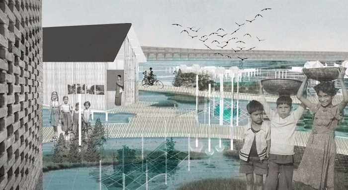
Howrah Bridge
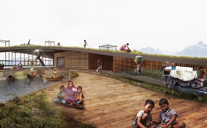
In Kolkata Flower Market, the population density and the continuous movement of coolies and flower sellers inspired us to create a floating extension of the flower market on the Hooghly. This is connected with resting/selling units and pedestrian pathways to the Howrah Bridge. The design vision for this site is to create an epicenter of social infrastructure, to support and enhance the peculiarities of the flower market.
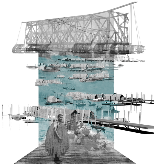
Kolkata flower market – Howrah bridge, floating flower market extension


Site Axon
Bridge performances
Multiple performances of the sleeping/selling pod
Detail of the pod sliding roof
Details of bamboo joints


Flower market model: rhizome
Flower market model: rhizome
Flower market model: rhizome
Sundarban Bund
In Sundarban we are proposing a new village paradigm that can face sea level rise and keep the local products on site thanks to floating farms. Services, such as education and health, become floating infrastructure that can serve multiple villages. Locals can use bricks and bamboo to build a bio-unit which can trap siltation and become emerging land where biodiversity can find suitable
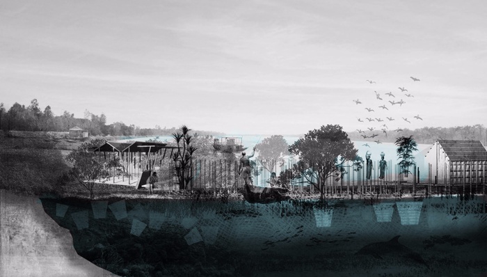
Sundarban – Floating village


Site Axon
Floating habitation with rain water harvesting unit
Details of the bio-unit


Model of the bio-unit and bamboo pathway
Model of the bio-unit and bamboo pathway
The Bengal 2050 vision and related stakeholders
“Bengal Flux” proposes an adaptive infrastructure for migrant ecological communities, changing the anthropocentric and land-centric interpretation of flowing water. Different stakeholders are going to be involved in order to provide education and know-how to the locals. Bamboo and bricks are the core materials for the implementation of the design proposal.
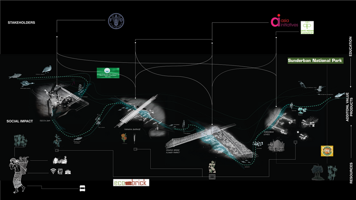
Stakeholders involved in the education process and collection of resources
The 2050 vision follows the idea of free-flowing river, where resistance to flow turns into adaptation. Fishes, birds, insects and humans will get natural benefit from a harmonious system where fixities are hacked. It equips current fixities in the landscape including dams, barrages, bridges, and levees to accommodate the dynamics of soil, fishes, birds and importantly, farmers. Its ultimate objective is to make a ground that embraces uncertainty and complexity.
Ecological relationships between the different sites
3
Precious Waste
Evelina Knodel, Yiran Hu, Jenny Lu, Daniel Ziss, Lavin Zhao
What if all of Kolkata’s waste were used productively in the mediation of existing social and environmental inequities?
Integration of Wetland and Urban Environment
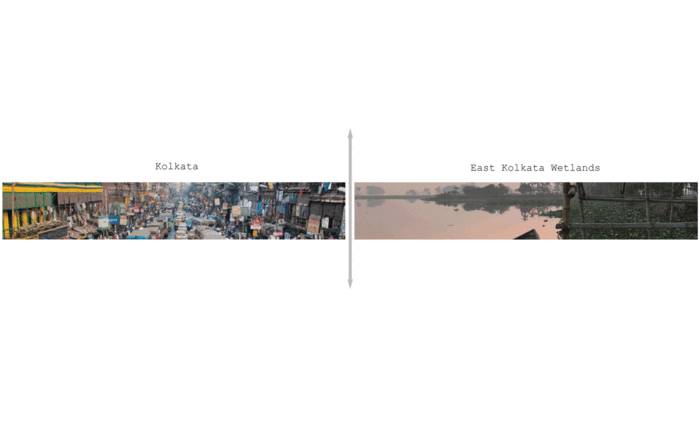
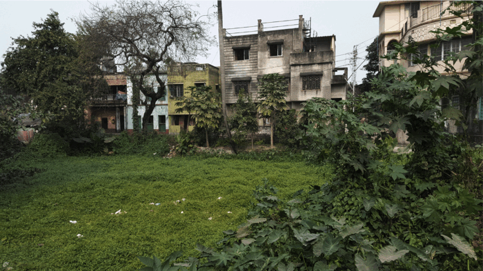
The East Kolkata Wetlands are currently the sole destination for almost all of Kolkata’s waste, both solid and liquid, saving the city millions of dollars in waste management costs and providing more than half of its fish and vegetable needs, yet developmental pressures are diminishing their capacity and endangering their survival. This proposal seeks to assign value to Kolkata’s “waste,” to expose the deleterious health conditions being caused by it, and to conceive of a landscape of “midgrounds” that serve to integrate the city with its wetlands.


Dhapa Waste Dump
Dhapa Waste Dump-Municipal Sewage Truck
Dhapa Water
Early Morning at the East Kolkata Wetlands
East Kolkata Wetland Cauliflower and Fish Ponds
East Kolkata Wetlands-A Trip with the Fishermen
Friends Near the Wetlands
Nutrient Build-Up from Canal Pollution
Polluted Canal Outflow
Wetland Fish Ponds-Sluice Gate
Wetlands-Hyacinth
City Encroaching on the Wetlands
Bathing in Municipal Water Pipe Leaks
Buffer of Hyacinth Along the Fish Ponds
Catching Fish
City Looming Over the Agricultural Fields of the Wetlands
Shrinking Wetlands
The current divide between city and wetlands can be understood in terms of “high grounds” and “low grounds” where the low grounds of the city are being marginalized so that city dwellers can continue to thoughtlessly consume and produce waste. Therefore, this gradient from high to low is a gradient not just of topography, but also of social and environmental equity. What many may not realize is that overburdening the wetlands leads to negative air quality for everyone. From perpetual fires at the landfill to the open-air burning of plastics for recycling to increased reliance on automobiles, high concentrations of aerosols cover every part of the city except for the East Kolkata Wetlands. Thus, not only are the wetlands providing food, habitat, and livelihood and processing the city’s waste, but they are cleansing the air and cooling the climate.
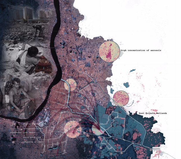
Impacts of the Air Quality on the Entire City of Kolkata
In order to first understand the current waste streams and their transmission through the city, we analyzed the lifecycle of a plastic bottle.

The Geography and Politics of Waste (Details Below)


Oil Extraction and Refining
Plastic Manufacturing
City and Landfill
Recycling Village and Wetlands
Sundarbans and Bay of Bengal
Most plastic bottles are made from PET plastic (PolyEthylene Triphosphate) which is derived from crude oil. Oil extraction not only releases CO2 into the atmosphere, but it destroys habitats and contaminates groundwater. After extraction, oil is transferred to an oil refinery. One of the largest oil refineries in the world likes in Gujarat, India and is owned and operated by Reliance Industries, Ltd. A drastic increase in plastic consumption in India can be tracked to the entrance of Reliance into India in 1971. Next, refined oil is taken to a manufacturing plant where it is transformed into plastic pellets, melted down, and formed into bottles through a process of stretch-blow molding. Manufacturing plants like the Coca-Cola plant right outside of Jaipur extract inordinate amounts of water from underground aquifers. Water table levels dropped around 45 feet over the course of just ten years in this region, contributing to lack of irrigation water for farmers and drinking water for villages. In 2010, this plant extracted 1,370,694 cubic meters of water for only $110.
Consumption of plastic bottles in Kolkata continues to increase rapidly with an estimated growth rate of 10.9% from 2010 to 2015, and it doesn’t appear to be slowing down. Reliance on plastic bottles has increased due to fear of water contamination and health impacts.
After consumption, all of Kolkata’s municipal solid waste is collected in trucks and hauled to the Dhapa dump site in the East Kolkata Wetlands, around 4,000 megatons per day. There is no source separation of waste. However, 10% of Kolkata’s waste is still recycled thanks to the presence of “trash diggers” who separate out the recyclables by hand and transport them to recycling villages on the outskirts of the city. Spending their days scavenging through the Dhapa in bare feet alongside bulldozers and wild dogs inhaling particulates and toxic fumes of burning refuse, it is not surprising that most trash diggers die before the age of fifty. At the recycling villages, no masks are to be found, but the stench of burning plastic permeates the atmosphere while young children run around playing. Plastic is separated out into its constituent types, melted down, cut into chunks, and then resold to plastic manufacturing companies to be made into things like toys and electrical wire coating.


Agricultural Land Next to the Dhapa
Cutting Melted Plastic for Recycling
Dhapa-Trash Diggers Carrying their Bounty
Laalkuti Recycling Village
Laalkuti Villagers
Melting Plastic for Recycling
Separating Plastic for Recycling
Setting Up Camp for a Long Day of Waste Picking
Sorting Waste by Hand
The Eerie Landscape of the Dhapa Dump
Much waste never even makes it to the Dhapa. Instead, it ends up in the waterways. The open canals of the city transmit 750 Million Liters of sewage waste from underground sewers all the way to the waste-fed fish ponds in the wetlands where an amazing process of natural bioremediation both treats the water and provides fish and vegetables for the city. Beyond the wetlands, both solid waste and sewage water make their way into the Kulti River, through the Sundarbans Mangrove Forest, and finally into the Bay of Bengal where a giant plastic gyre awaits. A recent study conservatively estimated that 5.25 trillion plastic particles weighing a total of 268,940 tons are currently floating in the world’s oceans impacting local economies and ecosystems (worldwatch.org).
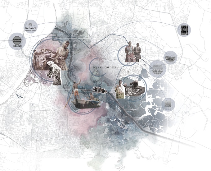
Needless to say, there are an incredible number of hidden social and environmental costs not accounted for by the petroleum and plastic industries, and that needs to change. We have calculated that the lifecycle cost of a plastic bottle now selling for Rs. 20 is Rs. 90. This extra Rs.70 should be absorbed by the refineries and manufacturing companies and should be put towards a new waste system for Kolkata.
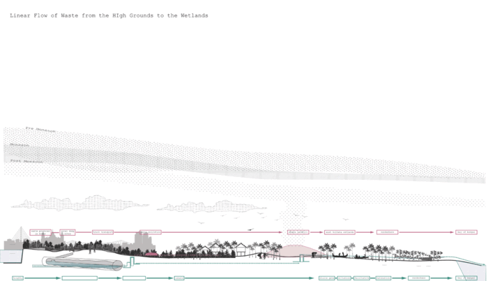
Finding Cyclical Opportunities in a Linear System
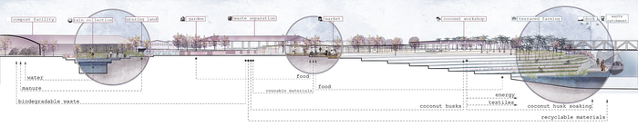
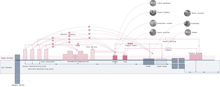
We are proposing the rethinking of the linear flow of waste into the wetlands. Separating waste and treating sewage water within the city can catalyze the generation of new “midgrounds” of economic and social opportunities. The Circular and Beliaghata canals provide the armature for this project, and are recast as an extension of the wetlands along which waste will be repurposed to generate new economies and to form the “midgrounds” between the geographic and social lows and highs of the city.


Canal Serves as Integrative Infrastructure
High Ground
Low Ground
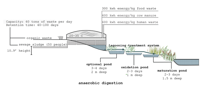
Local residents will be incentivized to separate waste at source. Waste for upcycling and further processing will be then transported throughout the city via the canal. Instead of going directly to the Dhapa landfill, it will be upcycled in various productive uses along the way. Our midground strategies include waste separation, anaerobic digesters, coconut groves and workshops, flower gardens, and urban agriculture, the logic behind which stems from the different types and proportions of waste generated in Kolkata (see Finding Cyclical Opportunities in a Linear System). For example, organic waste, which makes up 50% of the waste produced in Kolkata, will be composted for urban agriculture and flower farming or biodigested to create energy. This biodigester can also process sewage sludge from the underground sewers so that it no longer goes directly into the canal untreated.
Example of a Midground Strategy
Not only will waste separation and sewage treatment happen in a more efficient and harmonious way, we are also creating new economic and social opportunities for the entire city driven by healthy management of “waste” that is valued.

Strategies Demonstrated at Three Different Sites Along the Canal
Three sites at different points along the canal have been chosen to demonstrate these midground strategies. At each site, the creation of the “midgrounds” forms the connection between highground strategies and lowground strategies.
For example, in Site 01, a waste separation center and market are formed at the high ground while a constructed wetland and series of bioswales extend from the canal for biological sewage treatment. A coconut grove and workshop becomes the midground strategy as a high percentage of municipal waste consists of coconut shells that can be utilized for energy production or crafts and the trees from the grove can bioremediate the soil near the constructed wetland.


Buildings Along the Canal
Disintegrating Canal Edge
Exposed Sewer Pipe
Revitalizing the Canal Front
Site 1: Coconut Grove
Gradient of Activities from High Ground to Low Ground (Details Below)


Gradient of Activities- Detail 01
Gradient of Activities- Detail 02
Gradient of Activities- Detail 03
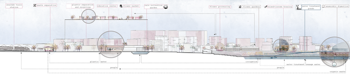
The second site is near the Sealdah Train Station and an existing flower market. At this site, the high ground strategies are waste separation, an education center, and housing, the lowground strategies are constructed wetlands and bioswales, and in between are flower gardens for both flower production and bioremediation.


Existing Flower Market
Highrises
Sealdah Train Station
Flower Garden and Education Center

Site 2: Flower Gardens
Flower Market and Anaerobic Digester (Details Below)


Flower Market and Anaerobic Digester- Detail 01
Flower Market and Anaerobic Digester- Detail 02
Flower Market and Anaerobic Digester- Detail 03
The third site is very close to the wetlands and suffers from flooding pressure and sewage overflows. Therefore, we are proposing the creation of flood-resistant high grounds from the excavation of new fish ponds in the low grounds. In between would be an agricultural and vegetative buffer for food production, pollution absorption and flood protection in anticipation of future sea-level rise.


Salt Lake Bypass
Billboards
New Development
Site 3: Urban Agriculture
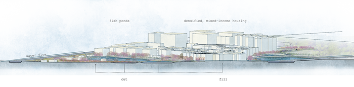
Design Strategy of Sustainable Development within the Wetlands


Harmony Between Ponds and Development-Detail 01
Harmony Between Ponds and Development-Detail 02
Harmony Between Ponds and Development-Detail 03
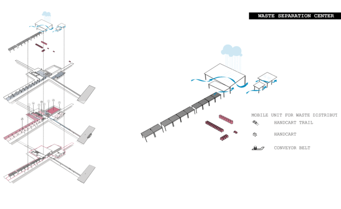
Waste Separation Center
We envision a new Kolkata that has fundamentally shifted its views on the value of its waste and its wetlands, in which solid waste is separated and sewage water is treated in harmony with the daily lives of all residents and the environment in which it lies.
Bottom-Up Implementation Through Local Involvement
Bottom-Up Implementation Through Local Involvement
With funding from oil and plastic manufacturers and support from the government and other local organizations, these efforts need to be driven by the innovation and incredible knowledge already present within the community, especially in the wetlands. This project provides the infrastructure for considerable change in the landscape and the mindsets of Kolkata residents, but it must be implemented by the people themselves—not just trash diggers, fish farmers, and informal settlers, but rich residents who will need to learn to separate out their own waste at source. Rather than a burden, waste becomes a catalyst for new economies, recreation, and revitalization of the canals. This is a vision for a new Kolkata no longer tainted by a halo of toxic blue smog, but a clean and beautiful city equalized by its waste.

A 2050 Vision: Disappearing Aerosols
4
Sacred Horizon
Students: Jessica Adiwijaya, Marwah Garib, Jesfae John
What if religious rituals along pilgrimage routes could be hacked for building ecological resilience?
Our project uses the pilgrim as an agent of ecological change and rituals as a process to enhance ecological restoration in Kolkata and the Sundarbans. We intend to put in place a flexible strategy that combats pollution of the Ganges River, the most revered river among Hindus, and replenish the rapidly depleting mangrove cover by working with existing spiritual sites and rituals in the Kolkata area. This is an area facing a looming threat of sea-level rise and the increasing frequency of severe cyclonic storms. Sacred Horizon aims to change perceptions and inspire people to recalibrate their relationship with nature.


The making of land through pilgrimage
Temporary plug-in infrastructure
Introduction
Water has played a continual key role in the belief system and culture of Hinduism, that Hinduism can be perceived as a religion of holy water. This appreciation of water is witnessed not only in literature, mythology, art and architecture; it is also seen in practices: worship, rituals and ceremonies. Although Hinduism encompasses so many beliefs surrounding water, the importance of striving to attain purity physical and spiritual cleanliness is key to these customs, and the belief that water provides the means for this cleansing gives it a central place in practices and beliefs. In order to absorb the merits of water, various consecrations, rituals and religious activities including pilgrimages and sacred baths are performed; and because of water’s central role, water itself is an important object of worship. Char Dham Tirtha(4 Divine Abodes) (‘Tirtha’ meaning ‘crossing’) is one of the major pilgrimage that consist of four well-known pilgrimage sites in 4 corners of India; Badrinath, Dwarka, Puri, & Rameswaram. It is considered particularly auspicious to undertake this pilgrimage at least once in a lifetime. Highlighting the sanctity of water further, routes between these sites marked by temples are situated on the banks of rivers, the Ganges being the most significant. This sixteen-hundred-mile river, which flows from the Himalayas through India and Bangladesh to the Bay of Bengal is the most revered river among Hindus. Many believe it to be the home of the goddess Ganga, a gift from the gods, and that bathing, drinking, or having their ashes scattered in this sacred river will wash away their sins and bring them closer to salvation.
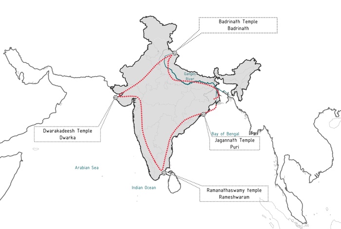
Chaar Dham pilgrimage route in India
Sites of Initiation
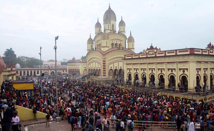
The city of Kolkata is dotted with temples to the goddess Kali. They are big and small, famous and anonymous, historical and contemporised. They are visited by devotees, religious-minded people, Bengalis and non-Bengalis, local, national and international tourists and pilgrims. The identity of Kolkata has often been associated with the ‘Kali‘ goddess who gave the city its name.
The Pilgrimage in Kolkata
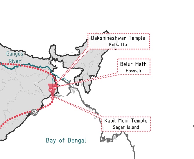
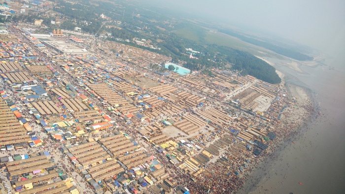
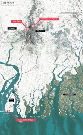
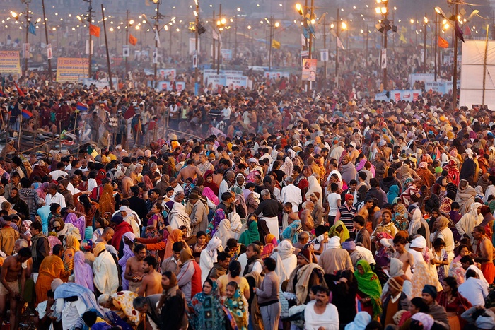
We initiate our work with a triad of sites that are located on a transect along the Hooghly River from Kolkata to Sagar Island located 80km south of the city at the confluence of the Hooghly and the Bay of Bengal. In the city, we focus on the Dakshineshwar Kali temple, Belur Math (math meaning monastery) and other Kali temples north of Kolkata on the Hooghly river; and on Sagar Island, we focus on the Kapil Muni Temple and its vicinity, site of a major pilgrimage event: the Gangasagar Mela (Mela meaning fair). This fair is held annually in the month of January on the festival of Makar Sankranti, when millions visit Sagar Island for a period of 3 days in what is said to be the second largest gathering after the holy Kumbh Mela held at Allahabad every 12 years.
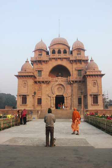
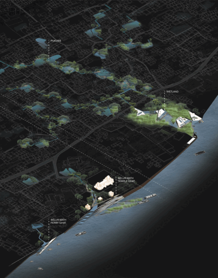
Belur Math in Kolkata City
Purpose of Intervention
1. Rising waters causing land loss
A World Bank report has expressed alarm over rising sea level in the Sundarbans, the world’s largest mangrove forest. Part of the world’s largest delta formed by the rivers Ganges, Brahmaputra and Meghna, the Sundarbans is also the world’s largest estuarine forest. Seas are rising more than twice as fast as the global average here in the Sundarbans(an estimated 3 to 8 mm rise per year). Comprising of about 200 islands in the Bay of Bengal and home to millions, it is listed as a UNESCO World Heritage site. Recent satellite analysis by the Indian Space Research Organisation shows that 3.71% of the mangrove and other forests in the area have disappeared along with significant amount of landmass to erosion in the past decade. The mangrove forest in West Bengal, which is contiguous with the Bangladesh Sundarbans, is an immensely fragile ecosystem and climate-change is one of the biggest threats to its existence.
Future Sea level rise projections show large parts of the city of Kolkata and Sagar Island submerged.
But the small islands on the fringe of the Sundarbans have been shifting, shrinking and disappearing as a result of increasing human interventions. Sagar Island is one among the 14 rapidly vanishing islands in the Sundarbans, mainly because erosion of land is happening at a faster rate than accretion. Kapil Muni Temple, located near the Gangasagar beach area where the Mela takes place has been rebuilt 4 times in the past couple of hundred years owing to its destruction by the sea.
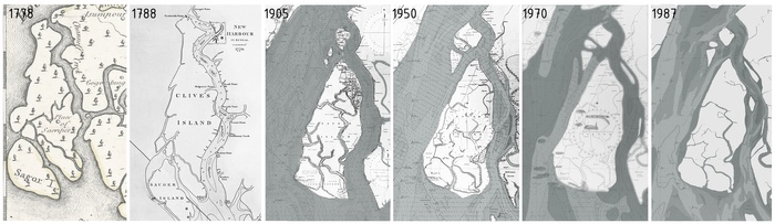
Shifting and shrinking shoreline of Sagar Island
Source: Library of Congress
Erosion and accretion of land due to the sedimentation process in Sagar Island
2. Rising Population causing congestion
India has a population of 1.3 billion people and is projected to surpass China by 2030 by the UN. Larger cities like Kolkata are experiencing increasing urbanisation with climbing population densities. Besides the strain on urban living and infrastructure, cities in particular are becoming places of frequent and large mass gatherings. Local events generate massive congestion in walled temple complexes in the event of a festival. Extreme crowding is a major factor that makes the spiritual experience of approaching and participating in the related ceremonies, particularly during festivals an entirely unpleasant one. Some environments are so congested that the risk of a disaster is ever present.
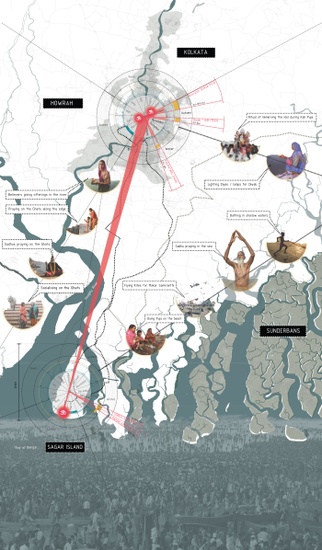
Festival calendar of the sacred sites in Kolkata and Sagar Island
3. The Ganges Paradox
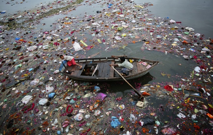
River Ganga, ‘the holiest of India’s rivers is also its most polluted’. Presently, the river is filled with garbage; dead bodies, both animal and human; hazardous chemicals like DDT and PCBs; and fecal coliforms in concentrations much higher than the safe level. The pollution is the cause of numerous health problems, including skin rashes, infections, parasitic diseases, birth defects, and cancer, for the millions of people who participate in rituals involving river water, rituals that are central to their religion. It is believed that the sacredness of the river makes it immune to the threats of overuse, contamination, and environmental degradation. This – the Ganges paradox as it is known – is one of the major obstacles to development.
Concept - Islands of Faith
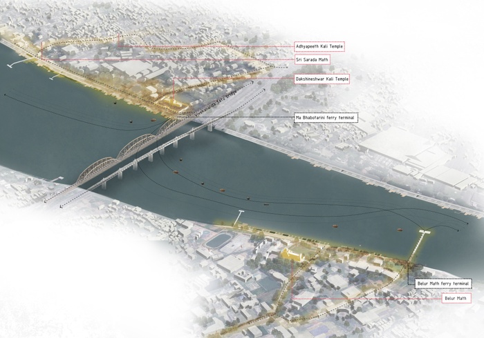
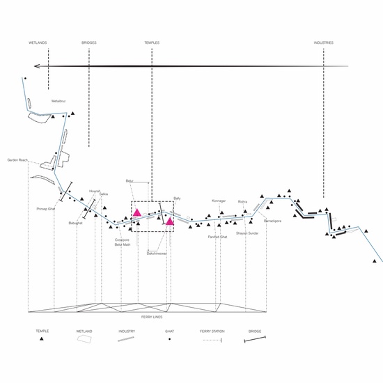
We consider the three sites – Dakshineshwar Kali temple on the east bank, Belur Math on the west bank of the River Hooghly, and Sagar Island on the sea - as three Islands of faith. Each has its own edges which are approached by pilgrims from land as well as water. We focus our design strategies on these edges, which are the primary places of interaction between pilgrims and the water they hold sacred. We equip these edges with Ghats (‘Ghats’ meaning steps leading down to the water) and ferry terminals with boardwalks which serve as a transportation infrastructure between the 3 sites.
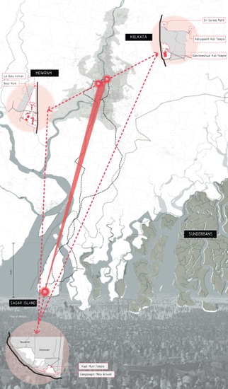
Three islands of faith along the Hooghly river
Implementation Strategy
Our project exploits the tremendous opportunity of the Hooghly River to aid the massive floating population that comes to Kolkata to commute between these three sacred spots of interest.
1. Pilgrims as active infrastructure
As the pilgrim route from Kolkata is considered holy by millions, we propose introducing an agenda to enhance vetiver & miscanthus cultivation along the River Hooghly(in the city) and mangrove cultivation around Sagar Island by hacking rituals using pilgrims as infrastructure. We believe that this initiative will lay the ground for a resilient ‘Gangasagar Mela City of the future’, one that is adaptable to the ever increasing pilgrim population.


Eco-spiritual gradient of the pilgrim journey (Part 1/3)
Eco-spiritual gradient of the pilgrim journey (Part 2/3)
Eco-spiritual gradient of the pilgrim journey (Part 3/3)
Eco-spiritual gradient of the pilgrim journey


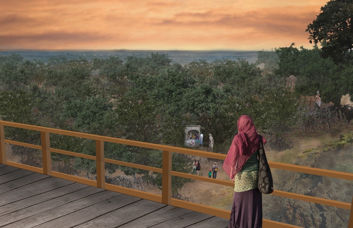
Building land by arranging bamboo stumps along the shoreline (Stage 1)
Pilgrims planting mangrove saplings on the built land along the shoreline (Stage 2)
Mature mangroves saving built land from being lost to the sea (Stage 3)
Saving Sagar Island by planting mangroves along the shoreline
2. Plug-ins: Engineering water and reclaiming public space
At Dakshineshwar and Belur Math, we are proposing to redesign the riverfront edge and the existing ghats to allow for public spaces and amenities engineered to treat the polluted water. The water is filtered along the edge by plugging in elements like floating pools, plazas and solid waste collecting systems to the existing physical infrastructures such as the Ghats and boardwalks. These plug-in elements are temporary by nature and deployed in accordance with seasons and festivals that attract large populations.


Plug-in typologies to existing boardwalk infrastructure
Plug-in typologies to existing ghats
Plug-in street typologies (½)
Plug-in street typologies (2/2)


Different combinations of the plug-ins deployed in dry season
Different combinations of the plug-ins deployed during monsoon
Different combinations of the plug-ins deployed in festival times
We strategically plug-in flexible street design strategies for the purpose of wayfinding from within the city to the water. We aim to increase visual connectivity so that the presence of water is felt by the pilgrims as they approach the edge.
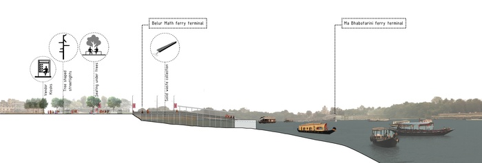
Relieving stress at ferry terminals
3. Multi-layering flood protection strategy at Sagar Island
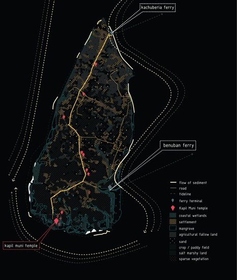
We propose a multi layered defense strategy along the island’s edge that would not only aid to protect both the tourist and local population but also essentially becomes a carrier of infrastructure itself. For this, we utilize a combination of nature based solutions such as mangroves afforestation, breakwater systems doubling as energy generators, backwaters and man-made solutions such as elevated walkways (also called ‘bunds’). These defenses are tailored to anchor a floating infrastructure of amenities for pilgrims coming to Sagar Island by house-boats.
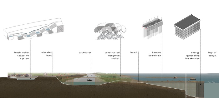
Multilayering flood protection strategy at Sagar Island
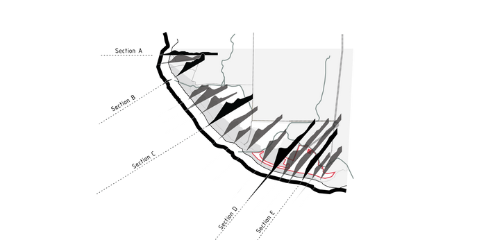
Key plan: Sections (below) at Sagar Island edge


Section A : Mangrove afforestation and elevated bund strategy at an existing ferry terminal
Section B : Bamboo boardwalk, Mangrove afforestation & elevated bund strategy
Section C : Energy generating breakwater, bamboo boardwalk, backwater, elevated bund and fresh water collection system strategy at existing beach
Section D : Energy generating breakwater, bamboo boardwalk, mangrove afforestation, backwater and elevated bund strategy at existing beach
Section E : Breakwater and elevated bund strategy at the Gangasagar Mela Ground
Vision 2050
Kolkata 2050


Sagar Island 2050
Present edge of Sagar Island (Adapted from Google maps)
Sagar Island shoreline replenished with the aid of pilgrim participation
5
Holding River / Flowing Rain
Students: Nabi Agzamov, Ge Zhao, Fu Wang, Elif Unsal
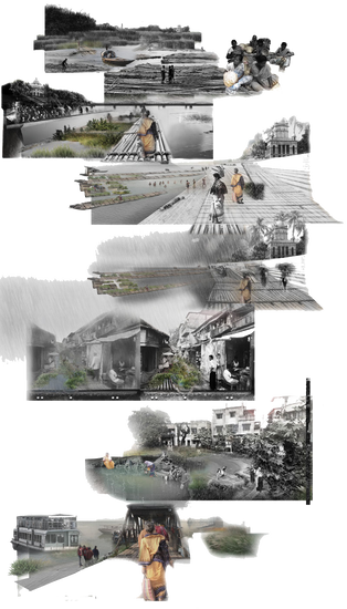
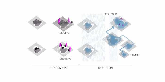
Kolkata is located in the delta of the river Ganga. Two systems of water appear to be at work here: a system of flows that comprise rivers and creeks, but also pipes, canals and drains; and a system of holding that comprise wetlands, lakes and pukurs, which are pond-like structures, many of them dug for harvesting rain and clay for construction. Five thousand pukurs have been counted in Kolkata and its twin city Howrah, many of them lying dry, underutilized and under increasing threat of encroachment. Their overflows during rains have proved to be a cause for floods as their link to one another and to the rivers that carry their excess water to the sea has been cut off by unplanned urbanization.
Flowing Rains / Holding Rivers seeks to re-integrate the two systems and in the process, remediate their waters and rejuvenate their adjacencies. It links pukurs with one another in a system of overflows that culminate in the River Hooghly, which runs between Kolkata and Howrah; and it holds back the waters of this river, which are heavily polluted, momentarily to contribute to cleaning it. The aim is to improve the lives of local residents and pilgrims.
Holds and Flows
Seasonal Fluctuation of the Hooghly and Monsoon Storm Water
Among city’s flowing rivers, creeks, drains and canals of Kolkata, one sees a large number of wetlands, lakes, and pukurs. Seeing this landscape through the lenses of flowing and holding, disconnects and tensions between the two systems start to reveal themselves.

Seasonal Precipitation (hold)
Seasonal River Fluctuation (flow)
Rain ( holds )
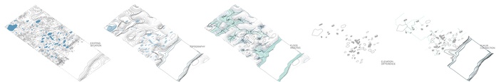
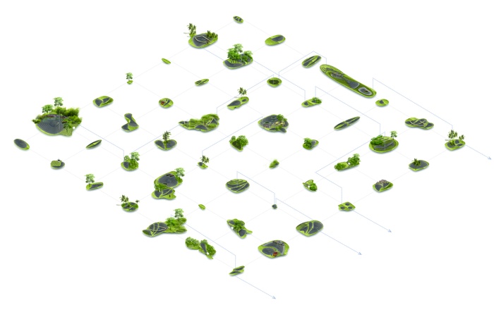
Pukur Typography
With rain storms becoming more severe and frequent with every monsoon, particularly in the wake of climate change, pukurs can provide much needed flood mediation. However, their overflows need to reach larger water bodies. Unlike in the cities of Southern India, where rain finds its way to a river, storm water here may meander through the city before finding a river.
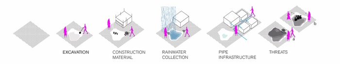
Pukur Design Strategy
Pukurs have long been an essential part of Bengali Culture. Some of these them date back more than three hundred years. They were rationally constructed for rain water harvesting, religious rituals, pisciculture, and the excavated soil was used as building material. Twenty years ago, there were around eight thousand ponds in Kolkata. Today this number is five thousand. Under constant pressure of development these water bodies are filled up and built upon.
River (flows)
Ganges is one of the most revered rivers in Hinduism. Unfortunately, it is also one of the most polluted and the Hooghly, one of its dis-tributaries, is among the most polluted in the delta.
Flowing System in Urban Context
Tidal fluctuations of this river are experienced both seasonally and daily. The difference from the lowest point of low-water in the dry season to the highest point of high-water in the rains is reported to be 6.35 m. The greatest mean rise of tide, about 4.9 m, takes place in March, April and May - with a declining range during the rainy season to a mean of 3.0 m, and a minimum during freshets of 1.07 m.
Bring Flows to Holds, and Holds to Flows
Proposed System Axonmetrics
After making room for water and introducing flows to holdings like the pukurs, the storm water overflows can reach the river as well as permeate the earth. The river can also enter the city though bioswales, based on natural topography, and existing urban flows.
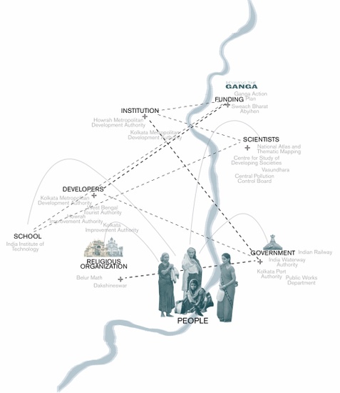
Participants
The network of the two water systems will be extended to different local and regional governmental offices, NGOs, schools, scientific communities, and religious organizations. However, local people, and visiting pilgrims become the engine of the project.
Flowing Rain
Hindus traditionally consider the excavation of water bodies a pious duty. The community can be engaged in the reintegration of the derelict pukurs.
Every pukur is separated into two sections. A larger area is elevated above the other and serves as an employment generator through pisciculture. Smaller portions of the ponds are dedicated for household water use.
Bioswale Path


Dry Season
Monsoon Season


Belur Math in Dry Season
Belur Math in Monsoon Season
In additional to being a public space, the bioswale help with flood mitigation, allows for circulation, and cleans the water as it travels between pukurs.
Holding River
As the Rain Flows into the Hooghly, it exits at the sites affixed to ghats. Ghats are connections between urban fabric and river.
The river serves as a site of holy bathing or immersions for thousands of Hindus. During Durga Pooja and Makar Sankranti festivals, it accepts the flow of millions of pilgrims. The pilgrims purchase and bring flower baskets as offerings to the river.
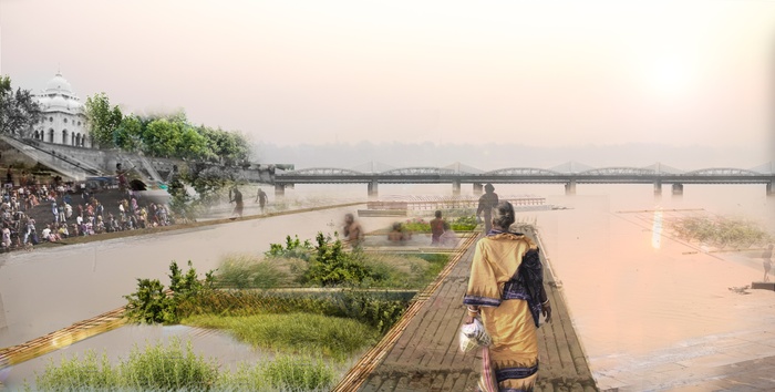
Bio-offering
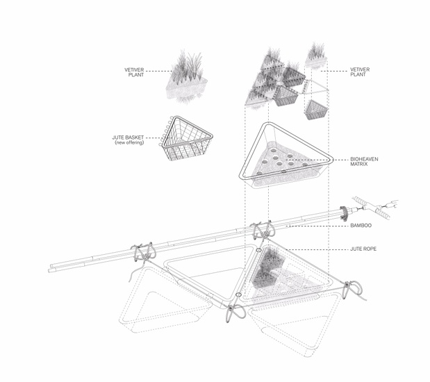
Based on Bio-Haven technology, bio-offerings are remediating units of vetiver plants. These units improve the water quality before it reaches the ghats, holding and filtering Hooghly water as it passes through. They also serve as habitats.
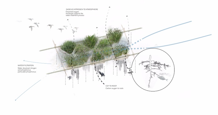
Temple Ghat
The frame that holds these offerings in place is tethered to the bank and to barges that anchored in the river. The floatability of the bamboo structure of this frame allows it to be used throughout the year
Ferry Ghat
Wetland Fish Market


Temple Ghat in Monsoon Season
Temple Ghat in Dry Season
Ferry Ghat
Kolkata 2050
Making room for water, making water as social space
Water shapes religious, economic, and social identity in Bengal, and India at large. As the region faces threats from climate change, and undergoes rapid urbanization perhaps it is wise to reintegrate the fragments of the ancient local water infrastructure and employ regional traditions in order to deal with the urban issues of the twenty first century. Perhaps these thousands of units fragmented throughout the city, and the region, are capable of not only holding rain but also relieving the stress on rivers.
Kolkata in 2050
6
32°F Armature
Students: Paul Xiaopu Wang, Huaxia Wu, Chu Li
32ºF Armature’s proposal to change the state of water to ice is a metaphor for the will to deliberately reshape the current floriculture and pisciculture economy in Kolkata. It is a sustainable hydro-morphology design project that counters the pressure of urbanization on rural Kolkata and accommodates the growth of grassroots industries benefitting the poorest people in rural areas.
Floriculture and Pisciculture in Kolkata
Pisciculture and floriculture play vital roles in Kolkata. The former fulfills the average resident’s need for food; the latter supplies flowers for social and religious practices.
Shifting Floriculture and Pisciculture Industries towards Rural Kolkata
Visual Documentary of Floriculture and Pisciculture


Floriculture_Urban Setting + Landscape Fabric
Flower in Calcuttans’ Spiritual Prosperity
Flower in Calcuttans’ Spiritual Prosperity
Flower in Calcuttans’ Spiritual Prosperity
Flower in Calcuttans’ Spiritual Prosperity
Flower in Calcuttans’ Spiritual Prosperity
Flower in Calcuttans’ Spiritual Prosperity
Flower in Calcuttans’ Spiritual Prosperity


Pisciculture_Urban Setting + Landscape Fabric
Pisciculture_Urban Setting + Landscape Fabric
Pisciculture_Urban Setting + Landscape Fabric
Pisciculture_Urban Setting + Landscape Fabric
Pisciculture_Urban Setting + Landscape Fabric
Pisciculture_Urban Setting + Landscape Fabric
Fish in Calcuttans’ Physical Well-being
Fish in Calcuttans’ Physical Well-being
Floriculture Current Condition
Currently, the floriculture industry supplies Kolkata with up to 1,500 tons of fresh-cut flowers comes from areas that are 12 travel-hours away. By the time they reach Malik Ghat Market from where they are distributed to retailers and temples, a large portion of flowers are withered and thus wasted.
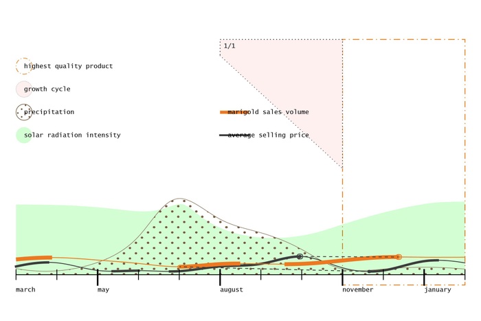
Floriculture_Hybrid Calendar: Sales vs Quality vs Weather Pattern
Floriculture_Distribution Network + Logistics
Pisciculture Current Condition
On the other hand, the wetlands east of Kolkata supply 13,000 tons of fish to the city annually while treating 60% of its sewage water. Yet pisciculture is losing people to other industries as fishermen struggle to make a profit as a result of the shallowing up of ponds caused by city pollution.
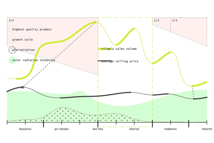
Pisciculture_Hybrid Calendar: Sales vs Quality vs Weather Pattern
Pisciculture_Hybrid Calendar: Sales vs Quality vs Weather Pattern
Indigenous Ice Making
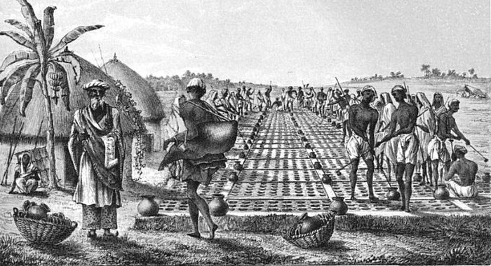
Pre 19th Century Method_Ice Manufacture Near Allahabad in 1828: Skimming Ice From Water-filled Pots
Despite ice-making being a long-existing tradition in Kolkata, the scarcity of ice today constrains the fish and flower industry by limiting the distance they can be transported and the time they can be stored.
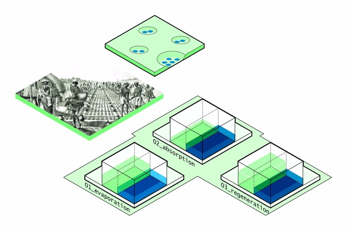
Indigenous Approach_Heat Exchange Mechanism
Innovation of Different Grades of Ice
Our proposal extends ice-making into the process of sewage treatment through the East Kolkata Wetlands and beyond. By making ice of varied qualities of water (black, grey and clean) in this process, our project caters to different needs of environmental cooling, fish/flower transportation and human consumption as well as different programs of human settlement.
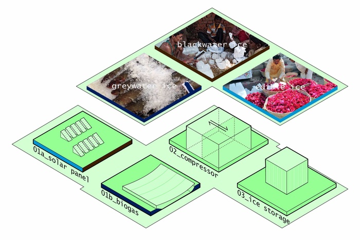
Ice Making_Modern Approach: Harvesting Sustainable Energy - Solar & Biogas Tech


Innovation of Different Grades of Ice: Blackwater Ice
Innovation of Different Grades of Ice: Blackwater Ice
Innovation of Different Grades of Ice: Edible Ice
Foundational Design Principles
Our ice-making initiative weaves in the agricultural calendar and seasonality of Kolkata, overlaying cycles of pisciculture, floriculture and ice-making with rainfall, solar radiation and temperature patterns.


Identify Design Principles_Ice in between Flower and Fish
Blackwater Ice_Design Principles
Greywater Ice_Design Principles
Edible Ice_Design Principles
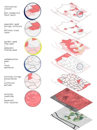
Regional Framework
We develop three interventions at critical points in this unique hydrological system for further design exploration. Each is designed to function all year round yet thrives in a particular time of the year as a result of site-specific conditions.


Regional Framework_Satellite Imagery
Regional Framework_Satellite Imagery
Regional Framework_Shifting Floriculture and Pisciculture Industries toward Rural Kolkata
Regional Framework_Scenario 1: Blackwater Ice Cooperatives
Regional Framework_Scenario 2: Greywater Ice Cooperatives
Regional Framework_Scenario 3: Edible Ice Cooperatives
Regional Framework_Ice Making Apparatus
Our proposed design scenarios anchor on the sewage canal which starts out from the center of Kolkata and extends across the east peri-urban areas. These scenarios integrate design interventions with topography, stimulating micro-economies of fish, flowers and ice while promoting associated industries, local markets, and residential development.
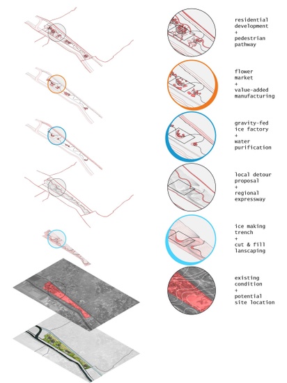
Scenario 1: Blackwater Ice Cooperatives
Site 1 is emphasized in the period from February to May when the temperature rises to its highest point of the year and ice is majorly used for environmental cooling. As this ice does not require direct contact with humans, it can be made with untreated sewage water.
Currently there are two parallel sewage channels with underutilized space in between them. By altering the micro topography and designing a trench to connect the parallel channels, a ‘delta’ area is created in between.
This space is then used to form a “blackwater ice co-operative” with ice workshops interlacing with air-conditioned social spaces and rooftops equipped with solar panels or designed as elevated recreation parks.


Design Scenario 1_Blackwater Ice Cooperatives: Design Principles
Design Scenario 1_Blackwater Ice Cooperatives: Future Implication
Scenario 2: Greywater Ice Cooperatives
Site 2 centers around the interval between June and October, during the monsoon season when fish production reaches its annual peak. This intervention is located in the middle of newly constructed wetlands.


Design Scenario 2_Greywater Ice Cooperatives: Design Principles
Design Scenario 2_Greywater Ice Cooperatives: Future Implication
As solar energy is inaccessible at this time of the year, the power supply comes from methane generated from fish waste. Ice factories hence sit adjacent to fish ponds and anaerobic ponds, with the former providing ‘grey water’ for ice and the latter offering biogas as power supply.
This “grey water ice” allows fresh fish to be transported longer distances, to last longer at market sales. It promises to trigger the development of the frozen fish industry.
Design Scenario 2_Greywater Ice Cooperatives: Design Strategy + Ecological Impact
Scenario 3: Edible Ice Cooperatives
Site 3 is focused on the time between November to January when Kolkata enjoys the strongest solar radiation and which is also the season with the highest flower production. The continuous solar energy supply for ice making can be combined with the flower byproduct industry.
At this site, the ice workshops are strategically located at low points along excavated water ditches in a gravity-fed system that allows water to be further purified and frozen for human consumption.
The “edible ice cooperative” projects an economic boom from iced beverages, scented water, tie-dye crafts, fish oil medication and other industries.


Design Scenario 3_Edible Ice Cooperatives: Design Principles
Design Scenario 3_Edible Ice Cooperatives: Future Implication
Design Scenario 3_Edible Ice Cooperatives: Design Strategy + Ecological Impact
Future Implication
These three interventions present three design scenarios each of which can be replicated at a larger scale depending on site conditions. Scenario 1 can extend along the sewage canal, scenario 2 can be applied to other high ground amid the wetlands and scenario 3 can be repeated in conditions with favorable topography and pond water source.
Ice Making Apparatus_Future Implication: 32°F Armature
By implementing these scenarios, 32ºF Armature structures a network that integrates ice, fish and flower to benefit the people economically and ecologically.
7
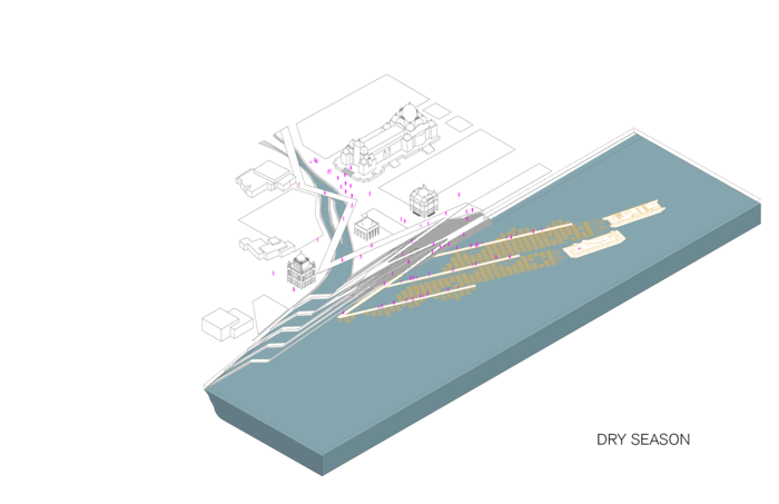
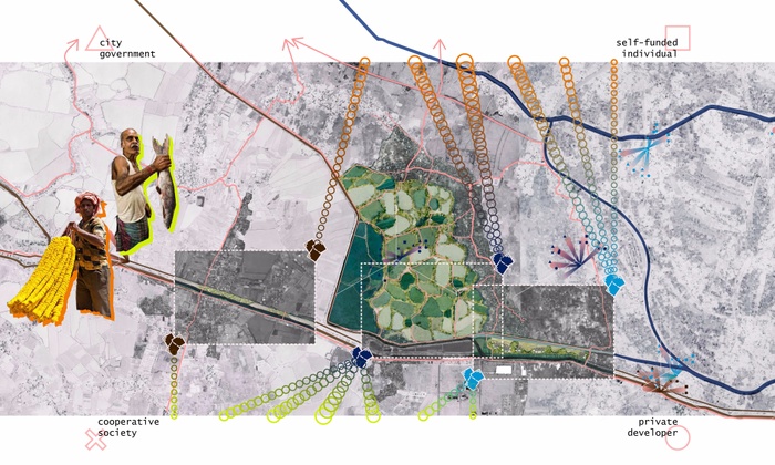
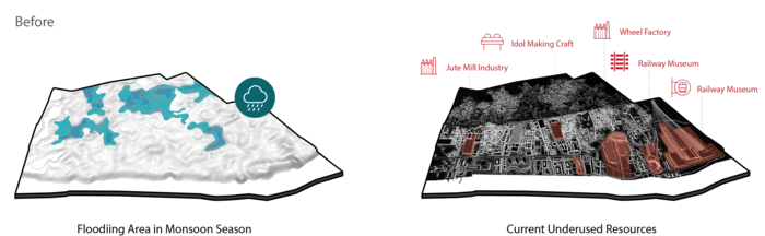
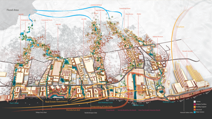
Reviving Kolkata’s Creek Economy
What if the historical creeks were revived and used to enpower the Howrah Junction area?
Historical evolution of Howrah Junction Area
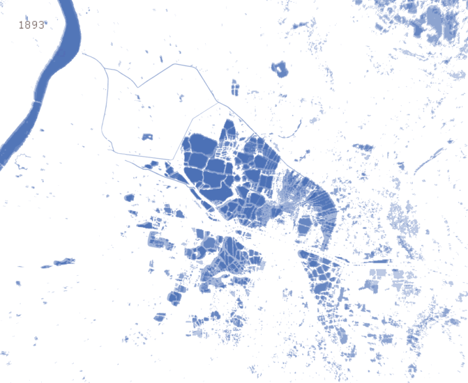
We counter a global-oriented riverfront development approach to Kolkata’s future with a local-oriented scheme that revives the city’s historical creeks. Unlike a riverfront approach, which brings development to the river’s edge, our proposal extends development deep into the city via creeks, catalyzing and stimulating what we call a creek economy. This is an economy that has declined, or rather reduced to a lesser status with the rise of the river economy promoted during colonial times. It is a decline that has followed the disappearance of creeks, reduced to gutters and drains.
Landsat detected differences between artificial and natural creeks
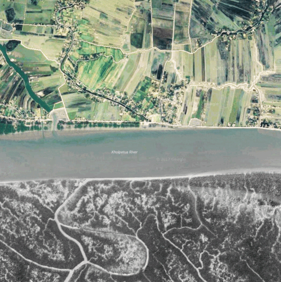
Creeks are a way of life in the Bengal Delta. They support the Mangrove ecology of the Sundarbans and the agricultural and craft economy of villages and towns.
Howrah Junction Area Situation
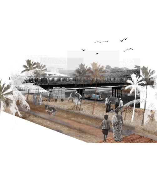
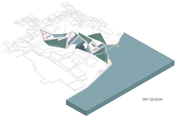
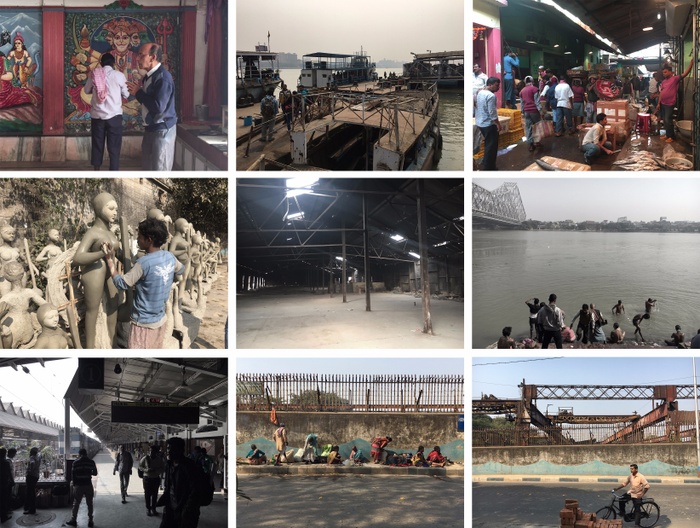
In this project, we revive a creek economy in the vicinity of Kolkata’s Howrah Station. During the 1800s the area thrived as an industrial district, capitalizing at the time on surrounding rail and port infrastructures. Before this time, this area was typically agricultural, organized along creeks that dominate the lower elevations of this deltaic landscape. Today, the port has moved further down the Hooghly River, but the rail station remains the primary entrance to the city, bringing pilgrims from all over the country to bathe in the river, which is venerated as Mother Ganga and to worship in temples along its bank. Industry has given way to crafts such as idol making, which uses clay, bamboo, hay and other local materials to make deities for the various festivals celebrated through out the year. The railway station has also spurned the growth of various wholesale markets such as the fish, vegetable and leaf markets. Together the craft industry and market’s have shaped an area of Kolkata that absorbs migrant workers, many of them farmers yet offers little towards their quality of life. Farmers and pilgrims alike, come from rural areas to supply the city with daily labor or for religious celebrations. With their families, they sleep in the streets and live along the river. Our project provides these people with shelter and opportunities that addresses their safety, health, livelihood and education.
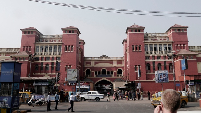
Howrah Station
Regional analysis along the Hooghly River and the Sundarbans
Historical evolution of the Hooghly river waterfront in Howrah
Creeks Lost and Found
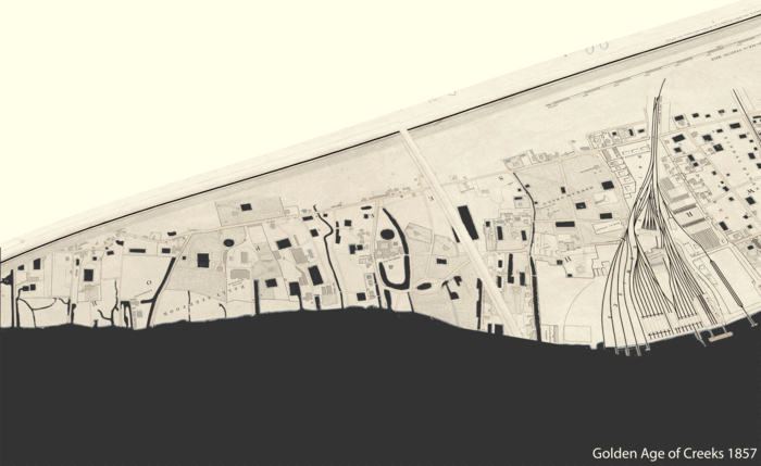
Until 1857 a creek system existed in Kolkata, supplying water and transportation for the industries that were introduced by the British East India Company and thereafter the Colonial government. Eventually however, with the decline of heavy industry coupled with city expansion, the creeks disappeared. In 1943, the Kolkata Port Trust infilled the western riverbank adjacent south of Howrah Station, reshaping the waterfront that was owned by them. With the port moving out of the city, development in the area has stagnated, leaving traces of a once vibrant urban fabric. Reconstructing the creeks promises to bring an interesting trajectory of improvement to this port land.
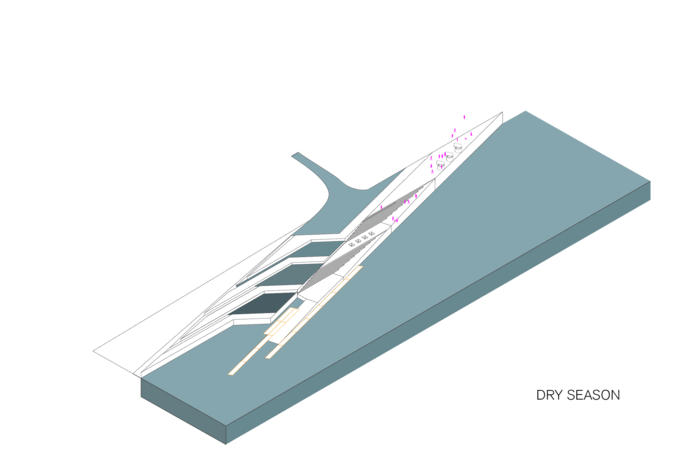
Design concept tested in different seasons
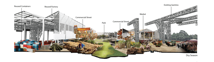
Design proposal along the warehouses in Howrah during monsoon and dry season
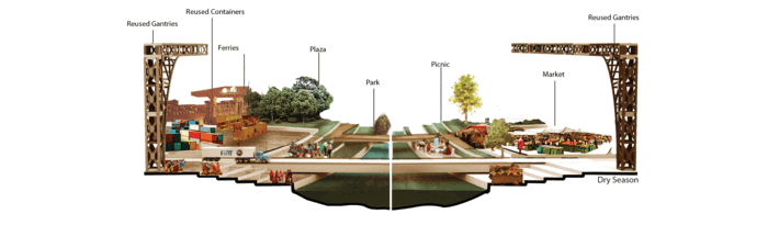
Design proposal creates new spaces for commercial activities and rituals during dry season and monsoon
Creek Strategy
1. Water Drainage System: Because of the natural topography and poor drainage system, low-lying areas are faced with a flooding problem during the summer. Heavy rains overwhelm the railway and affect over two lakh (two hundred thousand) residents. The revived creeks will link these flood-prone areas to the Hooghly River once again, restoring the natural pattern that enables the excess monsoon rains an exit route.
2. Industrial Heritage: The underused industrial facilities can be regenerated to provide site’s for the introduction of various new programs of the proposed creek economy.
2a. Railway Museum: As one of the few public infrastructures, the railway museum can play a vital role as a public parkland.
2b. Wheel Factory: A trade market and related craft workshops are proposed to utilize the interior space of the abandoned factory. It serves as a critical node along a transportation line that extends from the inland abandoned rail lines to a proposed river ferry and incorporates the reuse of the existing gantries.
2c. Abandoned Factory: A temporary public school is introduced offering primary education for the children of street sleepers.
3. Flexible Creek-bed: As water levels change dramatically between the dry and rainy seasons, the creek bed becomes a place for extending people’s activity from adjoining buildings. In the dry season, the creek bed can be seen and used for material processing and an outdoor market place while in the wet season, it can serve as a place for religious activities.
Four different strategies of creek revitalization
Four-Creek Strategy
We’re proposing the revival of four creeks in the Howrah Station area:
The Howrah Creek gathers underused industrial structures, which can be repurposed into a new market linking the rail and water transportation networks.
The Idol Creek enlarges this craft industry, making it an educational site for tourism.
The Cultural Creek organizes the Railway Museum as a cultural landscape and public amenity while also providing temporary housing for migrants in refurbished railroad cars.
The Port Creek is an armature for development in the second phase when the creeks will be extended into lower lying area towards the Mumbai-Kolkata Highway
Reviving Idol Creek
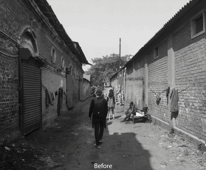
Design proposal in Idol Creek during dry season and monsoon
Afterword
Land-Waterscapes
One of the greatest scientific minds of the twentieth century, Werner Heisenberg, once said:
“It is probably true quite generally that in the history of human thinking the most fruitful developments frequently take place at those points where two different lines of thought meet.”
Two different lines of thought coalesced in an academic exchange between urban design faculty and students at Columbia University’s Graduate School of Architecture, Planning, and Preservation (GSAPP) in New York City and a similar group from the Indian Institute of Technology’s Ranbir and Chitra Gupta School of Infrastructure Design and Management in Kharagpur. The results of this productive dialogue, centered around issues of water, are documented in this book—they have been inspiring and useful in both local and international contexts.
During the fall of 2016, a core GSAPP team arrived in the historic “City of Joy,” otherwise known as Kolkata, with the intent to select a few significant spots or armatures in the city with the potential to inspire new opportunities and urban design innovations. These sites signaled transformative possibilities for the city’s urban ecology and greater regional estuarine-scape. 1
The full team from both universities converged again in early January 2017—this time for a longer stay marked by a series of site visits to the six chosen sites. Alongside this scheduled exploration, rigorous and iterative design discussions were carried out over the course of the first week. The work was showcased in a formal event in New Town Kolkata on January 11, 2017, entitled “Future Cities”. These exchanges were presented to a diverse crowd made up of people from governance, men and women from grounded action and grassroots, and those with local knowledge and expertise. The objective was to harness the spirit of young and promising urban designers and infrastructure students from New York and Kharagpur. It was a highly successful and engaging dialogue, and during the event, appreciation for such rigorous work and constructive criticism of the project poured in.
Under the guidance of professor Bharath Aithal of IIT Kharagpur, the group continued to explore the Sundarbans. The goal was to understand Kolkata relative to its vast ecological and estuarine foundations. A core group from IIT Kharagpur joined Columbia students to present and deliberate over a more developed version of the project at GSAPP in mid-March. Finally, in May 2017, the students from GSAPP presented their final project proposals to a jury of international experts. A small group of students from India joined for an exhibition on the final work in the concluding days of the semester.
Kolkata is both a city and a hub of a sprawling regional metropolis. The final project revealed the way in which design interventions, small and localized armatures, are embedded with transformative capacities that reach out to impact other sites beyond it—thereby facilitating a chain of integrated development. Many solutions emerged, for instance, the designation of armatures for the smooth transition from dense core to metropolitan periphery or a recovery of the river as a memory lifeline of navigation, ecology, and also new livelihoods that foster the local creative economic clusters from point to point.
Kolkata emerged from estuarine backwaters, from a onetime salty wetlands. The complexities and richness of the city’s embedded water base has yet to be tapped—its marshland underbelly is a story not yet fully told. Together, its sprawl, exuding up to and merging with the estuary, the larger bay of the river, and the Sundarbans mangroves form a greater ecology of design that has no natural boundaries. The six student projects in Kolkata proposed by Columbia and IIT elucidate that the city is still in a stage of development, along a gradient of formation, one that is neither very backward nor very advanced. Kolkata holds deep promise for life, growth, and lively potential of a unique economic and ecological land-waterscape—all of which promise that some form of resurrection will spring forth, moving the city beyond where it is now. This stage is best evident in the following words of Brian J. L. Berry:
“Calcutta is also characterized by a broadly concentric pattern of familism, an axial (or a large armature) arrangement of areas according to degree of literacy and both substantial and increasing specialization of areas in business and residential land uses, gradually replacing the former mixture of business and residences that were separated rather into occupational quarters. The mixture of pre-industrial and industrial ecologies lends support to the idea that the city is in some transitional development stage.”
It is with this understanding of the city that the six teams from Columbia GSAPP and IIT Kharagpur initiated their work to imagine and foresee the ecological, social and spatial pattern of urban transition.
Columbia University
Graduate School of Architecture, Planning and Preservation
Urban Design Program
411 Avery Hall, 1172 Amsterdam Avenue
New York, NY 10027
United States of America
Columbia University Faculty
Kate Orff, Coordinator, Ziad Jamaleddine, Petra Kempf, Nora Akawi, Laura Kurgan, Dilip DaCunha, Geeta Mehta, Julia Watson
Columbia University Students
Jessica Adiwijaya, Nabi Agzamov, Christopher Chiou, Marwah Atef Labib Garib, Yiran Hu, Linshu Huang, Carmelo Ignaccolo, Jesfae Mariam John, Evelina Shih Knodel, Chu Li, Zhengyin Lu, Grace N Ng, Deniz Onder, Yan Pang, Dissa Pidanti Raras, Kristen Reardon, Mario Andres Ulloa-Leon, Elif Merve Unsal, Fu Wang, Paul Xiaopu Wang, Huaxia Wu, Tianyang Xie, Zichang Yan, Xuanchen Zhang, Ge Zhao, Liwen Zhao, Daniel Ziss
Ranbir and Chitra Gupta School of Infrastructure Design and Management, Indian Institute of Technology, Kharagpur Students
Harsh Raj, Shivangi Singh Parmar, Akshay Sahu, Varun Raja, Dipanjan Nag, Navneet Singh, Ankita Mandal, Suparna Dasgupta, Sunny Bansal, Krishna Prakash, Toshan Sahu, Anshuman Dubey, Mouli Majumdar, Prashant Prasad, Atul Kant, Manish Agarwal
Special Thank You Ron Gupta, Joy Sen, Arkopal Goswami, Ankhi Banerji, Gita Balakrishnan, Debatosh Sahu, Sytse De Mat, Arkopal Goswami, Ankhi Banerjee, Bharath Aithal, Siddhartha Mukhopadhyay, Krishen Mehta, Runa Sen
This visit comprised of Prof. Geeta Mehta, Prof. Dilip DiCunha and Julia Watson, Prof. Kate Orff coordinated from NYC. The IIT Team had Prof. Arkopal Goswami, Prof. Ankhi Banerji and others. Additional coordination was in association with Ms. Gita Balakrishnan, Chair and Architect Debatosh Sahu, former secretary of the Indian institute of Architects, Kolkata Chapter.