
“Anyone who can solve the problems of water will be worthy of two Nobel prizes—one for peace and one for science.”
– President John F. Kennedy, 1962


FOREWORD
Madurai: City of Tanks
I am pleased that the faculty and students in the Urban Design Studio at Columbia University Graduate School of Architecture, Planning and Preservation and the Thiagarajar College of Engineering have focused on reimagining the issues of water and urbanism in Madurai.
Rapid economic development and urbanization are resulting in increasing real estate pressures and social inequities in the historic city of Madurai. Starting from around the famed Meenakshi temple, the city has now expanded into the agricultural areas, and traditional balance of water systems and urbanism is threatened. The issues of pollution and encroachment of the Vaigai River need to be considered carefully in this light. Architectural, historical, social, economic, and political ground realities have to be dealt with in holistic manner to achieve results that will be good for the city of Madurai, and for the region. I am also pleased that some innovative concepts and proposals have been produced and presented in this publication. I hope that these will be seen and considered by the various stakeholders in Madurai, and inspire thoughtful action.
Introduction
Water Urbanism
Water Urbanism is an innovative approach to design practice and pedagogy that holistically joins the study of social and physical infrastructures, public health, and hydrological systems. It challenges conventional planning practices that isolate elements of an urban system and instead starts with the assumption of a joint built and natural environment within which humans and machines operate. These complex, interrelated issues require a design-driven, integrative, and systems-based approach, one grounded in a deep understanding of social life, political context, and spatial thinking.


India Sub-Continent. A high contrast between west and east climate conditions
The Vaigai river basin lies in the shadow of the monsoon.
Madurai Metropolitan area was traditionally sustained by a system of rain-fed tanks and channels.
Madurai periphery is under an ecological stress due an uncontrolled urbanization.
Water Urbanism posits that water and cities must be understood within an expanded notion of a constructed ecosystem. These systems- including rainfall, water retention, water harvesting, industry and agriculture use, re-collection and re-cycling, culture, water access and sewage, are framed as opportunities within an urbanized ecology with the potential for design interventions along multiple points in the cycle. Water Urbanism also implies a set of design practices that engage people with policy and to continuously manage the urban eco-system to promote resilient communities and participatory practices. The spring semester 2016 Urban Design studio investigated these urbanization challenges in two regions with robust ecological contexts and development trajectories: the Vaigai River valley in Madurai, India and the Paraíba Valley in Brazil.
Madurai, India
An elegant, ancient water system that nourished rice fields and settlements has begun to collapse and needs to be rethought relative to expanding populations, public health, and ecological prerogatives.
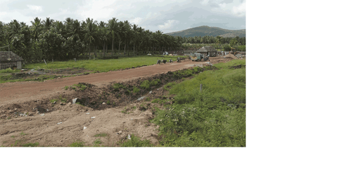
Madurai is a temple city of in the state of Tamil Nadu in South India and has been a major cultural center for over 2000 years, making it one of the oldest continually inhabited cities in the world. It is home to many historic monuments including, most famously, the Meenakshi Amman Temple which is visited by about 20,000 people every day. Today, Madurai is an important industrial hub with automobile, rubber and chemical manufacturing as well as information technology businesses. The city is also an important regional government and educational center. Madurai’s population is rapidly increasing, causing considerable stress and transformation. As a rapidly growing city with aging services and infrastructure, the periphery of Madurai has become home to informal settlements as well as a sprawl of commercial developments and high-end gated communities. Farmland along the Madurai- Dindigul corridor is urbanizing in a haphazard manner and north of the sacred Vaigai River, new development is mushrooming. Worse, the River and series of cascading water tanks has become contaminated by an inadequate sewage system.
The non-perennial Vaigai river and its elegant system of water holding tanks and channels that supported the urban and agricultural needs in this otherwise arid region for centuries is now damaged due to neglect, sand mining, encroachments and real estate pressures. Most of the water that flows to it from the Pariyar Dam in Kerala is stopped at the Vaigai Dam to serve the urban and agricultural needs of Madurai and its environs. The river is now dry much of the year and has become a dumping ground for urban waste. Along with many shrines in the riverbed where festivals and religious activities regularly occur, the dry riverbed is also used for washing and drying clothes, cattle grazing, marginal fishing and cricket. Reclaiming – or reinventing this imperiled water system is critical from a public health, urbanistic and social perspective.
The four projects in this book include a range of strategies and design practices that celebrate interdependence of social and physical systems design and and that envision a holistic urban-ecological future for Madurai.
Columbia Faculty: Kate Orff (Coordinator) Ziad Jamaleddine, Petra Kempf, Laura Kurgan, Guilherme Lassance, Geeta Mehta
1
Past, Present and Future of Urbanism Along the River Vaigai
The article focuses to give an overall picture about the River Vaigai in its present context. The increasing Land use and the urban expansion affect this river to a greater extent. The quality of the city to sustain its cultural capital for more than 2500 years on the banks of a non perennial river Vaigai is a unique feature. This feature exists in a complex web of tanks. In order to understand the river Vaigai one has to understand its geography in terms of physical and culture.
Vaigai River Basin (VRB) is one of the 34 river basins in Tamil Nadu covering an area of 7009 sq km. This River basin is surrounded by Cauvery and Pambar Kottakaraiyar basin on the north, Gundar River basin on the south, West by Periyar Bain and east by Bay of Bengal. The length of this basin is 289 km with its varies from 15 to 55 km. the basin is an arcuate in shape, stretching from the Western Ghats mountains of Kerala in the west to the Bay of Bengal in the east, with a general gradient towards North East up to Theni and then south eastern direction up to the sea.
Physiographical study of the VRB reveals that the basin can be broadly classified into three units namely:
- Western Mountainous terrain with valley complexes (running to a length nearly 70 km)
- Central Elevated terrain (nearly length about 110 km)
- Eastern Coastal Plain (nearly length about 35 km).
Administratively the VRB covers five districts namely Madurai, Ramanathapuram, Sivagangai, Dindugul and Theni Districts of Tamil Nadu. Urban settlements like Madurai, Cumbum, Theni, Manamadurai, Paramakudi located on the banks of Rive Vaigai have huge impacts on VRB
An Ecological Perspective of the Region
The southern peninsular India has more number of tanks because of its landscape, geography and terrain. Moreover the geological formation of this part is hard granite gneisses which serves as a barrier to the deep percolation from the tanks built above. The topography of Madurai region clearly exhibits numerous low level lands characterized by the shallow depressions and lakes that served as water sources from the historical times. These tanks were well-connected to rivers. The abundance of water from the river Vaigai is fed into small natural tanks and channels in the region. There are innumerable tanks and lakes on both sides of River Vaigai. These tanks are classified into System tanks (gets water from nearby rivers or reservoirs, may have its own catchment source) and Non system tanks (rain fed tanks). The system tanks get water through supply channels and surplus course. The former is designed as flood channel to carry large quantities of water during floods. The latter is an open channel sufficiently large to carry the surplus water from the tank to the next below tank or to the nearby stream. In the rivers that are not perennial such as River Vaigai, different methods had been adopted to collect all the flows of the basin. A large number (more than 2500 big and small) of tanks were constructed across water courses and small streams which contribute to the River Vaigai flows, thus moderating the floods. The surplus channel are more important in tank irrigation system as they are the links of a chain, which function as the most efficient water harvesting structures in arid plains. Within the urban limits Anuppanadi Channel, Paniyur Channel, Sottathatti channel, Avaniyapuram Channel takes off from the southern bank of the River Vaigai while Sellur channel, Pandalkudi Channel and Vandiyur channel feed into the river Vaigai from the northern side.
Urbanization & River Vaigai
Historically, the development of the city was noticed around the Meenakshi temple complex on the southern banks of River Vaigai. This agriculture based development gave equal importance to water structures in and around the regions. In the year 1866, Madurai city had a population of about 41,600 spread over a small area of 2.6 sq.km. In 1986 the area was extended to 51.85 sq.km having a population of 0.903 million. After independence in 1947, the city underwent major changes in terms of its spatial extent. The years 1951 and 1971 witnessed huge migration of the people from rural to Madurai urban area. During the last two decades Vaigai River basin within the urban limits witnessed radical transformation from agricultural land use till 1970 to its current state- a sprawling urban development in 2013. This growth was facilitated by the network of transportation corridors and other physical infrastructure. There are nine road bridges and two rail bridges across this river. The northern part of the city was urbanized after 1950’s and it had strong connections with the southern part of the city. Very high residential pattern is observed in the core city (more than 1000 persons / hectare).
Increase Impervious Surface Cover in these areas increases the surface run off, thereby decreasing the amount of infiltration inside the ground. As a result the availability of ground water in these areas dropped down to 135 m below the ground level in northern part of the city and 145m in stretch southern part of the city. Further the population density in this area is enormous compared to other areas. The ecological impacts of this growth and population re-distribution mark an important statement in these urban streams.


Madurai + surroundings.
Regional water infrastructure was complemented by localized systems.
Changes from the Early 1990’s
The changes on either banks of the river Vaigai was drastic from early 1990’s as the linkages from north and southern part of the city gained more connectivity.
- Traditionally the southern banks of the river enjoyed many ghat structures (Padithurai) that connects the land surface with water surfaces. Religious processions and rituals happen periodically in these areas.
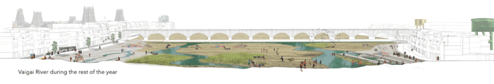
- The non perennial nature of the river completely provides different picture during different times. The character of the river changes to its peak during Chitrai Festival. Nearly six lakhs of people participate in this festival during April/ May. During June and July where there is least water, many portions of the river is used as play ground, drying yard and other illegal activities.
- Bund road laid in late 1990’s on either side of the river that completely destroyed the Ghat structures and also encroached 10 m on both sides of the river. Bund roads are encroached by commercial activities thus extending further 3 to 5 m on the river side.
- The excess sedimentation caused due to the land use in on the northern side of the river deposits thick layer of soil on top of the river bed. The strength of the non perennial river is the river sand that enables the purifying capacity of the river. This natural layer is drastically affected by the deposit layer facilitating the growth of many plants particularly seemai karuvai (prosopis juliflora) that completely alters the bed characters of the river.
- The storm water drainage acts as sewage drainage in the present state. The sewage from the northern side of the city is carried by Sellur , Pandalkudi channel and Vandiyur Channel, While Anupanadi, Sottathati Channel and panaiyur channel carries Sewage from the Southern side of the city.
- The Dhobiwallahs (washer man community) on the southern side of the river extensively uses the river for their washing purposes. There are around six locations inside the river that is been used exclusively for washing purposes.
- The river houses around 11 small temples along with two main mandabams (Pillared halls) Neeryazhi mandabam and Vandiyur mandabam within its bank. These temples are believed to be clan temples for communities inside the city.
- More residential areas like Nethaji Nagar, SMP colony, Shantiniketan, Madichiyam, Sellur on the northern side disposes solid wastes and raw sewage into to the river on a regular basis.
Emerging Potentials
The river in its present state gains more attention to the people of the Madurai as well as the Government Agencies. The Madurai Municipal Corporation developed City Sanitation Plan and City Perspective Plan for the city. Both the plans focus more on treatment plants for the sewage systems in the city. More than 5 NGO’s takes part actively in cleaning the river at sporadic intervals. The Public Work Departments prepares Micro level study of Vaigai River Basin focusing more on treating the entire basin as a single Planning unit. The Educational institutions conduct periodically awareness programs on the revitalization of the river Vaigai to its citizens. Recent study conducted by the Thiagarajar college of Engineering, Madurai clearly indicates that the river still holds self purifying capacity. The water within the urban limits is polluted whereas water on the peri urban area is fit for drinking. Thus river still projects a positive signal to its citizens.
The major missing link is the inclusion of the river as a planning unit in the Master Plan and Structural Plan. This Non Perennial River requires a special dedicated development plan to further sustain its cultural and functional integrity. It becomes a great priority for the educational and governmental organization to focus more developing and regulating a land use on the banks of the river and to adopt a suitable riparian landscape system on its edges.
2
Urban Portraits


Equity: How can motorized and non-motorized transportation share the street?
Identity: How can we build upon the strong cultural symbols of Madurai?
Appreciation: How can we expand the concept of sacredness?
Celebrate: How can we replicate vibrant street life in new spaces?
Reclamation: How can water stewardship be re-imagined?
Informality: How can we alleviate pressures on public infrastructure?
Social Infrastructure: How can we create responsive public housing?
Water Pollution: How can we value the water system?
Accessibility: How do we layer public infrastructure with public access?
Friction: How can agriculture lands be actively preserved in the urbanization process?
Integration: How can Madurai’s relationship to the Vaigai be formalized, but democratized?
Lifestyle: How can we preserve and enhanced agricultural traditions in urban life?

3
Student Project: Madurai ‘River'sed
Students: Adrinee Bodakian, Karan Daisaria, Anubha Joshi, Mahima Pandya
What if the channels linking Madurai’s historic water tanks became an apparatus for a new form of green, networked urbanism?
The project’s vision is to revive and preserve the historical water system sustained by its interlinkage of channels and tanks, through defining boundaries based not on districts but on the natural chain system of water corridors, formed by the channel and tank connections.
Pilot Areas: Special Zoning District
Madurai has historically had an intricate and interconnected chain of water systems which is severed from, and disrupted by uncontrolled urbanization.The increasing population and constantly growing urbanization present a bigger threat to the city’s already dysfunctional and dying water system, as well as to the public who have a growing demand for water in an already deficit state of water in lieu of water shortage projections based on climate change. The project’s vision is to revive and preserve the historical water system sustained by its interlinkage of channels and tanks, through generating an ecologically-driven zoning strategy based not on districts but on the natural chain system of water corridors, formed by the channel and tank connections.
The proposal takes advantage of both top-down approaches carried out by state or local governments, and bottom-up approaches which are empowered by the residents of distressed settlements in partnership with non-profit organizations. These strategies are manifested in the form of spatial design and written policies. The proposal identifies three avenues to intervene through, which are ecology, waste, and community engagement. The ecology of the region has suffered as a result of the uncontrolled urbanization, decreasing forest areas, green cover, habitat for wildlife, and the retention of surface water along the channels from seven moths of the year to three.
With uncontrolled urbanization have come many illegal actions by industries such as sand mining from the Vaigai River which has lowered the river-bed, causing the channels to dry up, which in turn have caused the tanks to dry up. These channels have become clogged by the sewage and plastic waste dumped into them. In cases of heavy rain, these channels overflow because of the blockage and flood the nearby neighborhoods. Often, the communities that are affected the worst as a result of these conditions, are those who are the poorest. The lack of proper attention, care, maintenance, and focus on the city’s water system consisting of tanks and channels has turned the city’s lifeline and major tourist and urban potential to threatening problems for the city’s future growth and safety.
In order to revive the water system, a change in the perception of the city must occur. Madurai’s special significance and public health lifeline is its water system. Hence, the project proposes Special Zoning Districts (SZDs) along the deteriorating water channels. The city is looked at through the lens of its water network and zones are allocated based on which channel they are connected to. The SZDs lay out policies for implementation aimed at the revitalization of the water system. The policies are to be carried out in a four phase action plan:
- Unclog which aims at the removal and treatment of solid waste and sewage from the channels.
- Capture which utilizes techniques for rain-catching and retention.
- Activate which aims at using the captured water to activate the channel edges by engaging the community.
- Preserve which aims at preserving and evolving the city’s water system for generations to come.
As a pilot project, the proposal looks at two of the SZDs, located at critical intersections and overlaps within the city’s fabric and region’s ecology. One of the selected channels drains from the Periyar Canal to the Vaigai River through the Vandiyur tank and the second channel drains from the Vaigai River into the Avaniyapuram mother tank. This corridor has different edge conditions such as peri-urban agriculture on the north, several middle-income housing developments, informal settlements, tanks that are drying up, and a combination of a dumping ground and a sewage treatment plant in the south. The project further scales down in order to zoom into a site that looks at a specific location in which the policies get carried out through spatial architectural design interventions.
Identify Framework & Special Zoning District
As urbanization spread across the landscape, the condition of the tanks further deteriorated to the point where by 2015, there were very few tanks that remained active as non-encroached basins for retaining water.
In order to change the perception of the city from a landscape of land-uses to a landscape dependent on its interconnection to the water system, a new layer of zoning is proposed that shifts the focus to the sustenance and health of the water system and its potential impacts on its adjacent landscapes.


Regional Analysis
Zone of Intervention
Policy + Action Plan
The Special Zoning Districts around the channels set up policies to be implemented across the zones. The implementation of these policies happens in a four stage action plan, UCAP (Unclog, Capture, Activate, Preserve). There are eight policies that are established, two policies in each phase:
Bridge Filter
A filter system is attached to existing bridges over the channels to trap plastic waste which can be easily removed and taken to the Plastic-Co for Social Capital Credits.Alternate Sewage Channel
A separate sewage line, utilizing the French Drain System, which runs parallel along the channel is proposed to protect the channels’ health.Sedimentation at River and Channel Junctions
Check dams for building sedimentation along the Vaigai are proposed for raising the riverbed and allowing flow into dried channelsRain Catching
Through softening the edges of the channels, creating meanders along them, and providing for basins in low-lying areas, the presence of water is maintained for a longer durationPublic Toilet
Within public areas, public toilets are proposed to bring safe bathrooms for women in the city, as well as menWater-based Public Infrastructure
Public spaces house public infrastructure which utilizes the water from the channel for creating community gathering spaces.Agri-Zone
A percentage of land along the channels is preserved for agriculture use only, which can happen in the form of traditional farming, or more progressive and advanced ways of growing foodFAR and Groundcover Policies
Green public space is proposed all along the channel, requiring setbacks from the channel, but in turn providing greater FAR and ground coverage for developers in return for maintaining the public space along the channel in front of their property.
Implementation On Site
Three sites are selected along the two pilot channels to test the methodology. From those three sites, one site is selected to further develop and detail out. This site is along the channel leading from the Periyar Canal from the North to the Vaigai River, which passes through the Vandiyur Tank. The site is located at the junction of channel and Vandiyur Tank, spreading southward and extending until the Vaigai River. The channel is divided to pass through our site in two directions. The new diverted channel is designed to pass through a newly proposed Bio-Diversity Park, a new middle-income housing development, and the SMP colony. Within the site are eight hospitals, many other institutions, businesses, a combination of middle-income group housing, and two communities in-formation, one of them being the SMP Colony.
An area adjacent to a milk industry is a government owned property which is low-lying and prone to flooding, which is currently used to let the runoff of the industry into. This area is proposed to become a bio-diversity park, which is maintained and cared for by the members of the communities in-formation. In exchange for their service, they receive social capital credits in the form of subsidized hospital check-ups and medications since these communities suffer from Malaria.
Vandiyur Tank + SMP colony
Reclaiming the Channels
The 4-phase action plan consists of:
- Unclog
- Capture
- Activate
- Preserve
The Unclog phase begins with installing bridge filters along the channels, where there are existing bridges. The bridge filters capture the plastic and solid waste in the channels, which then is turned into the Plastic-Co which is a recycling organization, in return for social capital credits which can be used for subsidized hospital visits and health check-ups. A separate sewage channel is proposed parallel to the channel, to further improve the health of the channel.
The Capture phase introduces a meandering channel that has soft edges which lead into a retention pond, surrounded by walking and biking paths, situated within an ecological park which restores bird migration patterns which have been lost, and bird sanctuaries, as well as the habitat for several wildlife species.


Unclog
Capture
Activate
Preserve
Biodiversity Park
An area adjacent to a milk industrial facility is a government owned property which is low-lying and prone to flooding, which is currently used to hold the runoff of the milk industry. This area is proposed to become a bio-diversity park, to be maintained and cared for by the members of the communities-in-formation nearby. In exchange for their service, they will receive SOCCS that can be redeemed to get health insurance, subsidized hospital check-ups, and medications since these communities suffer from Malaria and other curable diseases.
This area is used proposed to be used to direct the diverted channel into, where the channel meanders and retention ponds will be created, to hold water for a longer period throughout the year. Plants along the soft edges and natural channel beds will have a cleansing effect on the water. This, in turn, is expected to create a habitat for a diverse wildlife, and restoring the migratory bird patterns and ecological heritage which have been recently lost in Madurai.
The park is designed for a wet, dry, and flood seasons, utilizing the channel for different purposes through different climates.
Biodiversity Park at Dry and Wet Seasons
Activate: Social Space
The Activate phase utilizes the water from the channel, which is pumped to the community using the energy produced from the playground situated in the community. This water is filtered and used for community uses such as washing clothes.
The Preserve phase gives FAR and groundcover bonuses to the buildings along the channel in return for the maintenance of a green corridor along the channel, which becomes a linear public space creating and preserves lost bird habitat and tree cover within the city.
Activate: Action Phase
One site is selected, in order to detail out how the action plan can be carried out in its different phases. This site consists of the existing channel running adjacent to a community in formation. Within the site, the Activate phase takes dominance in terms of spacial design, utilizing the water from the channel by bringing in elements of design, consisting of energy creation, public space, public toilets, rain catching techniques, and community spaces. The water from the channel is pumped into the community via energy created from the swings in the children’s playground. As the children utilize the elements in the playground, energy is created and stored, which is later used to pump water for various uses, such as washing clothes. The water is also pumped to the public toilets for flushing. The water is filtered to different grades for different uses.
Neighborhood water-based interventions
4
Student Project: Rur-banizing
Students: Chenxing Li, Zhou Wu, Zhuoran Zhao
What if Madurai leapfrogged over countryside destruction and developed a joint “rur-ban” growth strategy through village-based agriculture hubs?
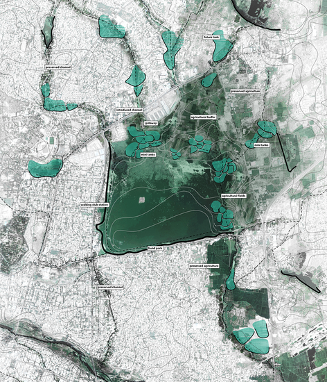
Rur-banizing proposes a new model of development for the periphery of Madurai corporation through a food hub-and-spokes network. This includes three strategies: a closed-loop water system, a food hub, and farming clusters. The programs proposed are to be implemented in three phases, and first be tested on the pilot site in Paravai, a site selected for a food hub by the Municipal Corporation.
Concept: Food Hub and Farming Clusters
Madurai is a Temple city that has also had robust farming traditions and food culture throughout its history. It has been the supplier of fresh produce to the region, and its renowned Jasmine flowers are world-renowned to various countries around the world for use in perfumes and ceremonial events. However, with the rapid urbanization of farmland and depletion of traditional water resources, farmers are now struggling to survive, and need new ways to add value to their agricultural products. Madurai is at a tipping point of urbanization and its countryside is endangered. It can follow other Indian cities that are experiencing haphazard urban sprawl challenging their resources and infrastructure, or it can leapfrog towards a different model of synergic growth between agriculture and urbanization, and maintain its unique culture.
To deal with this dilemma, we propose a new model of development for the periphery of Madurai corporation:, “Rur-banizing” the farmlands through a food hub-and-spokes network. This includes three strategies: a close-loop water system, a food hub, and farming clusters. The programs proposed are to be implemented in three phases, and first be tested on the pilot site in Paravai, a site selected for a food hub by the Municipal Corporation. We hope that through “Rur-banizing”, the fragmented farmland with uncertain future could be effectively organized to reintroduce an ecological farming system, to foster economic development in the rural area, and to increase the resiliency of the entire region.
The food hub-and-spoke prototype is proposed to initiate the process outlined above. The hub will stimulate the development of its surrounding areas through spokes. This prototype will include much needed agricultural facilities including an information center to enable small farmers to stay competitive, distribution systems, and model farms to demonstrate closed-loop water and ecological practices. The hub will be connected through telecommunications and transport to a series of farming clusters of farm cooperatives and new housing units that will form a dense ring to discourage unplanned urbanization. The pilot site in Paravai will demonstrate ways to heal the connection between the traditional water tank systems and the Vaigai River. Enabling urban settlements and farmland to co-exist in a mutually beneficial way while preserving Madurai’s jasmine and milk production.
The three stages of this process will start with the construction of the water system to relieve water shortage in this area. Following that, the information center, women’s center, labs and distribution centers will be built to empower the farmers in nearby villages with information about farm inputs and prices, advanced technologies, education and social supports. In the last phase, skilled farmers from Madurai region will be invited to the farm clusters where they can build their modular housing units and continue to demonstrate the latest farm technologies with help from the Tamil Nadu Agricultural University and other institutions. The last phase of the proposal will also include a network of farmer markets and agro-tourism.
The proposed food hub-and-spoke prototype is designed to be replicated in other sites in the Madurai region in the future, introducing the new “Rur-banizing” periphery to the rapidly growing city. This will not only act as a new and flexible iteration of the historic green belt concept but also create a productive landscape where a robust development of agriculture, urbanization, and economy can be realized.


Countryside at Risk
Madurai is faced with challenges of urban encroachment, water shortage and profit loss in their agricultural products. During our visit there, we saw farmers selling paddy fields to developers, in which way they could get more money. On top of that, farmers in Tamil Nadu committed suicide there because they cannot get irrigating water from failed borewells. Though Madurai is so famous for its jasmine that the perfume designer from Dior visits Madurai every year, the add-value is taken by exotic merchants instead of local farmers.
Analysis: Haphazard Consumption of Land / Strategy: Rurbanizing
Opportunities
Madurai has unique water networks with thousands of tanks connecting to dams and Vaigai River, which keep irrigating the robust farmlands. More than that, there is social infrastructure potential from the local foundations, research institute,s and the government. So there are opportunities to reintroduce the ecological farming tradition with the assistance of institute-farmer cooperation.


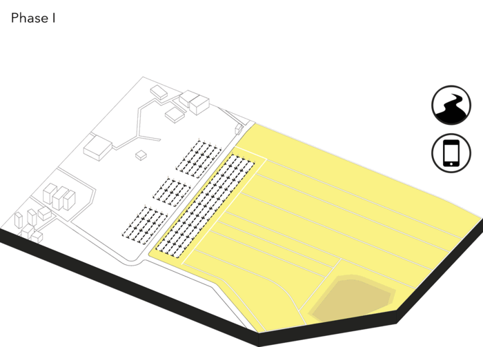
Phase I: Information Offices + Water Infrastructure + Farmland Parcelization
First, an information center will collect and share the farming news. Based in Paravai, it can provide a price platform and seed resources to its surrounding nine villages with 6,000 people. To keep updated information, it will frequently contact with Meenakshi flower market in the city center, Amul Diary the main milk buyout company, and Rameswaram where the jasmine shoots are cultivated.
On top of that, a comprehensive water infrastructure will be constructed to obtain water from Katchirairuppu Lake, filtering and transporting it to distributed water towers for future settlement use. The farmland will be parceled and remedied according to organic farm standards, which require two years’ soil remediation and symbiotic cultivation with more human labor caring than pesticides. Based on this, the farmland is divided into seven minimum-size organic farming units of approximately ten acres for future cultivation.
Phase II: Labs + Women Center + Transportation Networks + Demonstration Cluster Modularization
Building on the information network, a series of small-unit labs, a women’s center and transportation networks will strengthen links in the product chains, bringing both economic and social benefit to surrounding farmers. The labs will be sponsored by relevant institutes, from the raw material collection, cold storage, to package processing, covering services for the whole production. This association of “glocal labs” could also organize lab tours, reaching out to their potential networks. To help with the women farmer majority, the women’s center will provide services like job opportunities, training program, healthcare, entertainment and safe warranty, such as free raw material pick-up, to improve their quality of life. The complete transportation network will build the connection to central markets and distribution centers such as bus terminals, train stations, and the airport.
Besides the service support, the settlement modularization will also be conducted farming cluster demonstration. It is a series of standard housing-scale frames with daily and farming service facilities in each cluster, defining the edge of human construction in order to protect the farmland. In the future, a series of clusters will be created as village growing prototypes to demonstrate an ecological settlement mode with the local farming system.
In this stage, our stakeholders will also join into different programs to give all-around support. The stakeholder group consists of all levels of government, agricultural and engineering institutions, social organizations such as Dhan Foundation, and local celebrities who are involved in related fields.
Sustainable Farmer Cluster
Phase III: Ecological Farming Cluster Demonstration
Once the network is established, the farming demonstration clusters will be constructed in a flexible way. For these newly-planed clusters, its scale and residents are carefully estimated accommodate 70 to 100 family units in seven dispersed clusters, resulting in 10 to 12 units each cluster. These people consisted of skilled farmers from nearby villages, unemployed local people, and also technicians from relevant institutions, who can conduct product plantation. To construct the housing units, a standard frame, and raw materials is prepared for each family. After being trained by experts, they can make the materials into building materials, self-decide the layouts and self-construct their houses within the frame.
For farmland in this village, a symbiotic agricultural system and waste management are emphasized. In product selection, we treat jasmine and cows as our featured products according to its physical condition. On top of that, we propose a symbiotic system including coconuts, bananas, chicken and fish to enhance the biological diversity. The 10 family units in each cluster, directed by agricultural experts, could self-organized to coordinate with each other to balance the species in the appropriate ratio. This rotation planting system will also warrant all-year round profit for farmers.
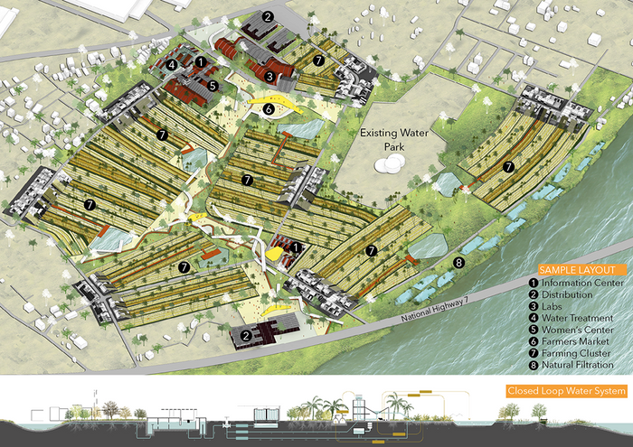
Sample Layout
Food Hub
An information center will collect and share the farming news. A series of small-unit labs, a women’s center and transportation networks will strengthen links in the product chains, bringing both economic and social benefit to surrounding farmers.
Food Hub (Before/After)
Farming Clusters
For these newly-planned clusters, its scale and residents are carefully estimated accommodate 70 to 100 family units in seven dispersed clusters, resulting in 10 to 12 units each cluster. For farmland in this village, a symbiotic agricultural system and waste management are emphasized.
Farming Clusters (Before/After)
Farmers Market
In the last phase, we have agro-tourism and farmers and tourists can meet and transect in the market. The canopy and pavement define the area in between the clusters, and people can gather and have various activities here.
Farmers Market (Before/After)
5
Student Project: Water Rites
Students: Aminata Seck, Cameron Cortez, Nicolas del Valle, Vinh Le
What if Madurai created a series of public spaces to mitigate water-related inequity along the Vaigai River?
The proposal uses the edges of the River Vaigai and the municipal overhead tanks as tools to address water inequity for the diverse residents and pilgrims of Madurai. Water Rites proposes public pools and ecological filtration areas to support and formalize sites for the bathing, laundry, commerce, and recreation that have long occurred along the river’s edges.
Vaigai River in Madurai
Madurai is one of the most important religious cities in southern India. Every year, during the festival month of Chithirai, the city hosts a rapid influx of around 1,000,000 domestic pilgrims, who temporarily inhabit the city’s streets and riverbed, giving the city an incredible transient population. Like most large cities, its population and urban density have also significantly increased over time because of an accelerated flow of people leaving rural areas seeking alternative jobs and education. One of the most crucial contemporary infrastructural issues is water (its sourcing, distribution, access, reuse, relationship with sewage, and its political governing). The current water distribution system of the Madurai Corporation entirely depends on the Vaigai Dam piping water to a network of overhead water tanks that distribute the amenity through purchasable domestic and commercial plumbing infrastructure.
As a result of this primarily financial constraint, 50% of the city’s population does not have formal access to potable water to exercise their rituals and necessities of daily life, and is therefore dependent on informal water sources such as private wells, the River Vaigai, and “natural” surface tanks for basic water-related amenities. In addition, 28% of the city’s population is using open space for toilet-related amenities. These fundamental problems of water-related equity are not only affecting the physical environment, they are producing increasingly wide-spread societal conflict.

Characters of Madurai.
The proposal uses the edges of the River Vaigai and the municipal overhead tanks as tools to address this inequity for the diverse residents and pilgrims of Madurai:
1. River Vaigai Edges
This project proposes public pools and ecological filtration areas to support and formalize sites for the bathing, laundry, commerce, and recreation that have long occurred along the river’s edges. These interventions will be located at critically active nodes along eight km of the river Vaigai, interfacing with the Chithirai Festival’s main riverbed concentration point, informal residential areas, bus stations, and institutions. Formally, the interventions are inspired by the traditional “Ghats” but are intended to actively capture, distribute, and filter water to address societal and ecological needs. Schematically, the underlying system is a series of contoured social pools that are connected to a series of phytoremediation pools by a gate, which are situated at the same elevation as the riverbed. The insertion of this system into the riverbed allows for fluctuating volumes of water to passively enter and exit the interventions by their natural velocities. These interventions also facilitate access to the riverbed itself, an action that has long been discouraged by the concrete bund roads that presently line the Vaigai’s edges.
2. Municipal Overhead Tanks
There are currently 28 overhead tanks and a network of pipelines that extend across 72 of the 100 wards of the city. There is an abundance of publicly-owned open space below and around these tanks that is presently made inaccessible by a variety of fences and physical barriers. Rather than extend the dense pipelines of these tanks further into the growing city, this proposal regulates the opening of these sites to their surrounding urban fabric, so that they may become sites for public toilets as well as for the retrieval of potable water. It is the intention to make the role of these overhead tanks more transparent, and the water they hold and distribute more accessible; the sites also will also contain vegetated spaces for socializing and resting, to passively offset the heat of Madurai’s warm climate. Like the Vaigai’s edges, this project turns this system of overhead tanks into new icons that signify the access of basic amenities for the citizens of Madurai, both permanent and transient.
Regional Context, Precipitation and Water Movement
Water is traced from the Western Ghats, where it is captured within the Vaigai Dam, and released both mechanically into the River Vaigai, where it eventually meets the sea, as well as pumped to serve regional municipalities, such as the Madurai Corporation.
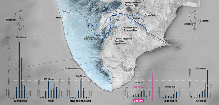
Rainfall in major cities of south India.
Current Municipal Water Distribution System
Until 2013 the city of Madurai had 28 overhead tanks inside the boundaries of the Corporation. These elements represent the presence of clean potable water in the city. From these points, the water is transmitted to home through a system of private pipes. Due to the cost of these connections, only 48% of the population living within the boundaries of Madurai Corporation has access to clean drinking water.
Current Surface Water Tanks System
By contrast, the 52% of the population that can’t afford the connection to clean water depends on alternative sources. These alternative sources are private water wells, points of municipal water distribution, and mainly the Surface Water Tanks System. This system is composed of a series of canals, retention tanks and the Vaigai River running across the city surface. Originally created to provide water for agriculture purposes now this system is the source of water for cooking, drinking and basic amenities such laundry and bathing.
The main points of access to this system are located along the Vaigai River and the major water tanks. The conditions of access to these points are restricted by several barriers like concrete walls and fences built to prevent encroachment of adjacent properties.
In terms of quality, the water quality is recommended to not drink this water if it’s not treated due the high levels of minerals on it. A situation that increases, even more, the social inequity related to water accessibility.
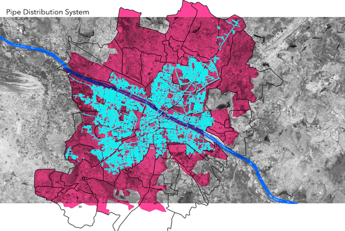
Pipe Distribution System Vs Surface Tank Distribution System
Site prototyping / Relevant Adjacencies
- Kooldal Nagar Railway
- E.S.I. Hospital
- Crematorium
- Arapalayam Bus Station
- Government Hospital
- Capron Hall Girls’ Secondary School
- Madurai Junction Railway Station
- Bus Stop
- Meenakshi Amman Temple
- Sri Meenakshi Government College
- Annamalai Theatre
- Government Rajaji Hospital, Madurai Medical College, The American College, Playground, Rajaji Park, Gandhi Memorial Museum
- Sourashtra Boys Higher Secondary School
- Raghavendra Hospital
- Adlabs Ganesh Cinema
- BIG Cinemas
- Nirmala Girls Higher Secondary School
- Muktheeswarar Temple Meenakshi, Sundareswarar Girls Higher Secondary School
- Thiagarajar College
- Teppakkulam
- SMP Colony
- Madurai Corporation
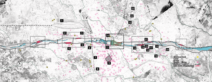
Potential Sites of Intervention


Overhead Tanks Site + River Edge Intervention
Phyto-remediation. Passive filtration adjacent to the baths along the River Vaigai.
Bio-remediation. Passive filtration at the existing canals within the city of Madurai.
Form & Logic Seasonal Bath Variance
A series of pools are inset into a larger pool, that constitutes the public bath. These pools are shaped by the flow and volume of water within the River Vaigai. Depending on these temporal parameters, the baths change in form and definition.


River Edge Proposal
Logic & Design of the baths
6
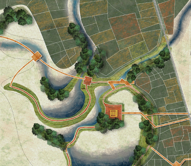
Student Project: Think Tank
Students: Marshall Allen, Amanda Chan, Sebastian Delpino, Despo Thoma
What if Madurai’s ancient water tank system became the driver for new adaptive growth?
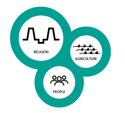
Think Tank aims to radically shift the perception of Madurai’s tanks by making them the front yard of the city rather than the currently neglected back yard. Through the lens of water and stewardship, our proposal seeks to look at the multi-scalar water system of Madurai and adapt the system through a change of governance, to fit modern environmental and social conditions. The water system is comprised of interconnected tanks and their respective communities. By focusing on these individual units, Think Tank aims to strengthen the social and physical structure at a local scale in order to have an impact on the system as a whole.
Introduction
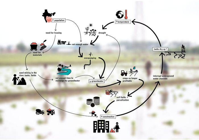
Madurai’s urban history has evolved and flourished around an elaborate water system consisting of tanks, canals, channels, and drains. Today, the city faces a tipping point because of rapid urbanization pressures where if nothing is done, the water system will cease to exist.
The water system of Madurai has sustained the city for centuries due to its necessity for religious, agricultural and social practices. Religion is a fundamental aspect of the Hindu faith and ultimately, the water system was devised as a way to sustain religious tanks with water throughout the year in a historically arid climate. Agriculture was a method for retaining and using water in a responsible way that both supplied the city with fresh, locally grown food as well as guaranteeing water in the final religious tanks. And finally, with religion being such an important part of life in Madurai, much of the social practices of the city focuses and supported certain ideologies that inherently use and preserved the water system.
These three core elements have historically been linked with each other through water but currently, these links are beginning to break. Agricultural fields are being parceled and sold for development. Channels are clogged with garbage and sewage. And the tanks are drying up at an alarming rate. These events continue to spur further development and as such, further environmental and social degradation.
Interconnected social and environmental threats
Concept
Think Tank aims to radically shift the perception of the tanks by making them the front yard of the city rather than the currently neglected back yard. Through the lens of water and stewardship, our proposal seeks to look at the multi-scalar water system of Madurai and adapt the system to a change of governance, to fit modern environmental and social conditions. The water system is comprised of interconnected tanks and their respective communities. By focusing on these individual units, Think Tank aims to strengthen the social and physical structure at a local scale in order to have an impact on the system as a whole.
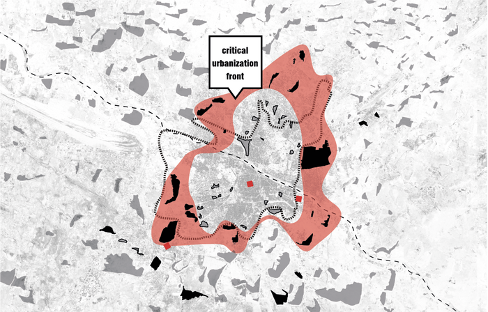
Zone of intervention
Methodology
A crucial component to Think Tank is a replicable strategy that would be applied to other tanks throughout Madurai that are currently or will someday experience the pressures of urbanization. Through the process of identifying existing conditions, establishing tank saving policies, activating public space and adapting the tank for modern environmental conditions, the water system of Madurai can be managed on a tank by tank basis. Gathering stewards in the form of local institutions, and community or civic groups, an adapted system of governance is introduced in order to maintain and manage the tanks. These groups will also be held accountable for the caretaking for this vital resource while also being able to use it for their benefit.


Berm on the hard edge
Encroachment
The only existing designed relation
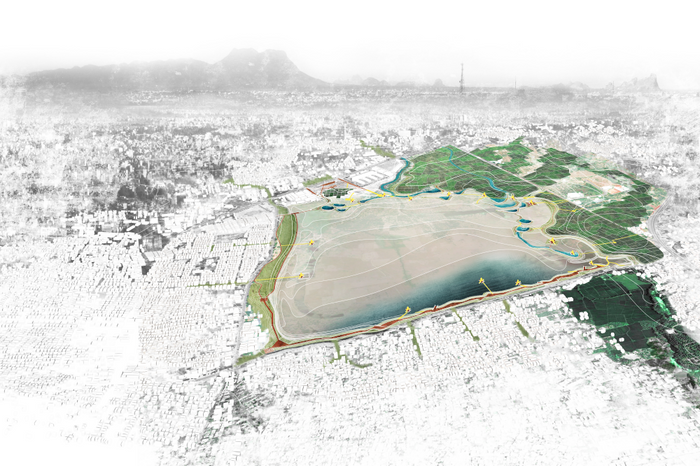
Vandiyur Tank as a New Front Yard
STEP 1: IDENTIFY
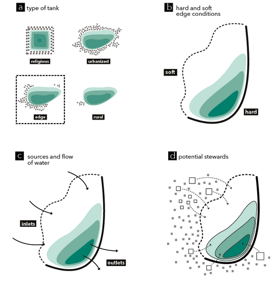
A. Identify the type of tank (religious, urbanized, edge, rural) and focus on the edge tanks which are at the front line of the urbanization process.
B. Locate the hard edge and the soft edge of thank. The hard edge is usually defined by a piece of infrastructure that creates a barrier between the community and the water. The soft edge is undefined by any physical or visual element and is usually a zone prone to encroachment by settlements of agricultural fields.
C. Understand the water flow. Identify the inlets and outlets for each tank.
D. Take an inventory of the surrounding land use and context, such as institutions, community groups, local markets, civic organizations, agricultural land, small-scale residential and large developments.
D.1 Identify potential stewards that will be responsible for taking care of the tank and will benefit by utilizing areas around the tank for their own specific program.
D.2 Enact policy for stewards that choose to take part in this arrangement.
Hold groups accountable for the stewardship (yearly dues, trash pickup, water quality tests).
Ensure that there is a benefit for these groups in that their program will be incorporated into the design of the adapted tank.
System of Mother Tank and Baby Tanks
STEP 2: ESTABLISH
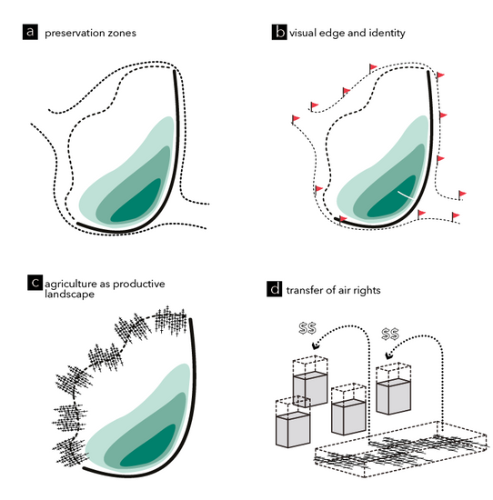
A. Understand and declare the boundary of the tank, specifically the undefined boundary (soft edge). Consult historical maps to understand the high water mark of the tank and demarcate what the highest capacity is (for future rainfall events). Declare tank preservation zones- stating that no further building shall take place within this boundary. Declare the existing encroachment is illegal.
B. Make new edge visually identifiable for each tank to create an identity and indicate the newly established boundary. Use of colors or signals to signalize the periphery of the tank.
C. Preserve and incorporate agriculture with further development surrounding the tank to create a productive landscape buffer. Development should only happen with the preservation and incorporation of agricultural fields.
D. Use the policy of transferring air rights over the agricultural land and sell to adjacent parcels to allow for taller, dense development that would capture the value that would be created around the tank.
Visual Demarcation
STEP 3: ACTIVATE
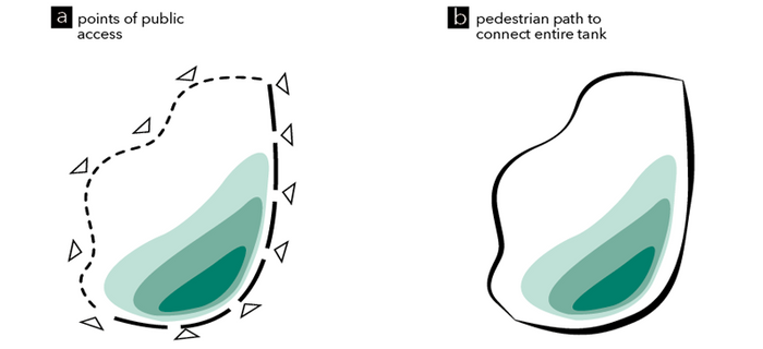
A. Determine strategic points for public access into the tank based on surrounding land uses and pull associated programs and activities into the tank. Provide public spaces along with all edges of the tank, allowing “eyes on the tank.”
B. Activate the edges by incorporating pedestrian paths and public spaces. Create extensions of existing land uses by using different widths of the path and connecting to the surrounding context. The path will also extend into the tank at various locations to provide direct relationships and interactions with the water. Focus all activity towards the tank.


Bund Park Section
Public Access
STEP 4: ADAPT
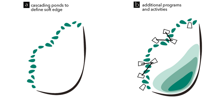
A. Implement smaller adapted tank system. Direct the flow of water from the inlets to the outlets along the soft edge of the tank. Use a series of interconnected, cascading ponds in order to define the edge and avoid further encroachment, illegal activities, and misuse within the tank. The ponds will choreograph the water to flow along the soft edge of the tank throughout the year.
B. Establish a series of vertical elements -activity stations. They will be programmed to reflect adjacent land uses and stewards. They will also be a visually connecting element that will help pull people into the site and view the entire pond from a higher perspective.


Soft Edge Access
Defining the Soft Edge
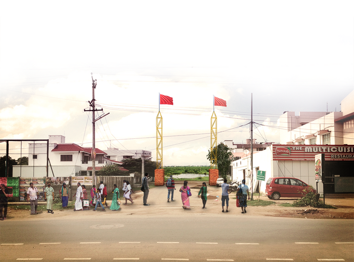
Bus Terminal Gateway
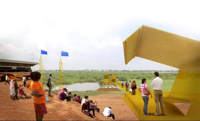
The already encroached north side of the Vandiyur tank is adapted to incorporate the two existing uses (bus terminal and flower market) in order to create a public space that is a new gateway to the tank. The adaptation aims to unify the two public uses and refocus them towards the tank. Currently, both the bus terminal and the flower market have no interaction with the tank. The vacant parcel between them is prone to further encroachment and it has been identified as a crucial point of intervention. By redirecting an existing channel, we create a new inlet in the public space that then forms the first series of cascading ponds that lead to the agricultural buffer. Markets, small ponds and a terraced ghat landscape integrate other elements in this gateway. Activity stations that hold viewing platforms, amphitheaters, and waiting/ bathing areas create points of reference in the vast landscape of the Vandiyur tank.
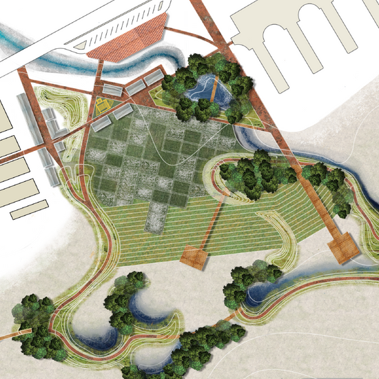
Soft Edge Definition
Using a series of cascading ponds, the agricultural buffer zone, dry and wet paths and activity stations, we define the undefined and usually encroached soft edge of the Vandiyur tank. The berms that form the ponds are accessible according to the seasons, whether wet or dry. The ponds can overflow during the monsoon season into the larger tank allowing that to fill up as it historically has. During dry periods, however, water flows from pond to pond allowing the entire system to work at a much smaller scale. Intentionally dry areas can host activities such as sports, markets or gathering spaces. These temporal uses are manifested here due to the absence of any public or civic spaces in the surrounding neighborhood. Insofar, the ponds act as a soft definition of the edge and at the same time, as an amenity for the immediate neighborhood.
The Vision for Madurai
Madurai’s existence depends on the presence of water. Religious, agricultural and social practices are all interconnected by water and serve as the sustaining three core elements of this Southern Indian city. Facing increasing environmental and social challenges due to rapid urbanization, the water system is severely threatened. Think Tank seeks to change the perception of the cities image from a Temple City to a Tank City with the goal of helping people to understand that it is the entire water system that should be celebrated and protected. By adapting the water system for modern conditions, we create a replicable strategy that will transform all of the tanks of Madurai into a catalyst for increased environmental, ecological and social stewardship.
AFTERWORD
Rethinking the Smart City
The Smart City Mission and related financial commitments announced on India’s Independence Day in 2015 are an excellent opportunity to assess and define what “smart” means for Indian cities. The stated goal of the Mission is to promote economic opportunity, improve governance, and make cities people friendly. Social equity and ecological resilience are not the key part of the Mission, but given the state of Indian cities today, they should be. Cities cannot be made smart by addressing financial capital alone, and must understand and enhance their ecological and social capital too. Madurai is among the 100 cities that have been selected for this Mission, and illustrates why these factors are also important if Indian cities are to become truly smart.
What is not smart? How can we redefine the Smart City through its Ecological and Social Capital?
Speculative urbanism driven solely by real estate interests and mono-functional planning is not smart. Such urbanism is a result of a process in which projects are measured in terms of financial returns without care to social or environmental context. Indian government entities are increasingly becoming dealers of public land rather than providers of public good. This is happening at a rapid pace all across India, resulting in rampant and haphazard urbanization of agricultural and public land. As an example, this trend is robbing the Madurai Region of its historic reputation for supplying rice, jasmine and vegetables, while also marginalizing farm jobs. While retrofitting, redevelopment of existing neighborhoods are also proposed in the Smart City Mission, these are not financially as lucrative as new tabula rasa approach proposed, which will eat up precious farmland, especially if calculations and approvals for these project are based upon financial capital alone. However, the paradigm will change completely if urban design prerogatives on green infrastructure, public space, civil life, and life cycle costing including social and environmental impact are considered.
While 480 billion rupees (US$7.5 billion) committed for the Smart City Mission by the Central Government are to be matched by State and Local Governments, several times these amounts are expected to be raised from the private sector. The neo-liberal economic model being promoted by the current Government in India seeks to make investing in cities, not just in real estate, good business. This is a good step forward, but only if triple bottom line impact statements including financial, social and environmental impact are required of every new project. At present Indian developers make between 100~400% profit on their projects, among the highest in the world, while no social or environmental responsibility is required of them. The Smart City Mission should change that.
Extreme social inequity that currently exists and is increasing in Madurai as well as most Indian cities is not smart. Urban development that denies 50% of the country’s urban population the dignity of reasonable shelter, livelihood and healthcare is not smart. It is equivalent to ignoring 50% of the economic and social potential of the city. Lack of adequate shelter for this large a percentage of population will make impossible the attainment of nearly all Sustainable Development Goals (SDGs) by 2030 as agreed to by India with UN and other signatory countries. Especially threatened are the SDGs related to poverty reduction, health and gender equity. A KPMG paper entitled Housing for All by 2022 commissioned by the Finance Ministry in 2014 projects a housing short fall of 110 million by 2022, 70% of which will be in the affordable housing sector, unless policies are improved. The Union Budget of 2015 includes a budget for 60 million homes, although the implementation has had a slow start . Homes that have been built in the past by the Slum Redevelopment Authority and other government programs are cookie cutter style residential blocks with little connectivity to the work place or urban infrastructure as was observed in the SMP Colony in Madurai discussed further in this document. Smarter alternatives with user participation and the investment sector are needed.
What is smart?
Learning from history and designing for a sustainable future is smart. Madurai region has had a centuries old system of harvesting every bit of rainwater for use in agriculture and urban consumption through the system of interconnected tanks, canals, channels, and the Vaigai River. The genius of this system was in harnessing social capital for the maintenance of the system so that there was accountability and responsibility built into it. This system started to breakdown during the British period and deteriorated rapidly during the post Independence period as trends shifted towards engineering solutions and the historic systems considered obsolete. Since the liberalization of India’s economy in 1990s, the real estate pressures and government apathy have resulted in the loss of many tanks in Madurai as they are illegally filled in and informal or even government approved residential and commercial properties are built on them. Loss of each tank or channel leads to further damage to the integrity of the water systems, but also increases the risk of floods. This was made evident in Chennai when the Columbia Urban Design Studio visited Madurai in December 2015. As shown in the Studio work presented in this document, the tanks and channel that form the intricate water can still be rejuvenated, but strong political will is needed. How can dumping 80% of the sewage untreated into the sacred Vaigai River be smart? In the interviews conducted with stakeholders during Studio visit to Madurai, it was evident that many government officials do not understand the urgency of this situation, or the potential of its revival. While several academics at the Thiagarajar College have deep understanding the issues, there is need of a more robust dialogue between the government, academia and general public. All Smart City projects should include an evaluation and learning from smart traditional practices related to ecological sustainability. The fact that the Smart City program requires an element of public participation in all projects is a step in the right direction, although it would be useful if the modalities of this participation are made clear.
Harnessing the “youth dividend” of India entails education, skill development and job creation but also safe streets, public spaces and public transport. Attention to these in all Smart City projects would be smart. Designing cities to empower women is not only smart, but will enable them to participate in the workforce and help realize the Smart City goal of increasing the economy- by about 10-13% according to a International Monetary Fund estimate . The International Labor Organization report in 2014 pointed out that contrary to expectation, the participation of women in Indian labor force declined even as its economy grew at a health 7% between 2004-2011 . It is largely because of inadequate safety and infrastructure for women in Indian cities and villages.
A smart vision specific to India
When asked what their image of the Smart City is, most officials and businessmen interviewed in Madurai gave examples of Western cities, citing their highways, flyovers, and tall glassy buildings. Singapore was quoted as an example of a desirable city. Admiration about the speed of development in Chinese cities was expressed in several conversations. Roads that would prioritize pedestrians and bikes were not brought up. No one outside the Thiagarajar College of Engineering mentioned incremental development and retrofitting of viable neighborhoods as a move worthy of a smart city. The importance of reviving traditional water systems, when mentioned by our team, was mostly considered uninteresting. This is problematic, and once again points to the need for a robust dialogue between the pros and cons of new megaprojects and their impact on economic opportunity, social equity and environment.
User generated cities
The big issue in rapidly growing cities in India is that big projects are favored over small ones, largely because they are more lucrative and easier to manage. These projects invariably cause more environmental and social damage than shown in plans. This is because the people are not seen as part of the solution and their social capital unrecognized and not harnessed. Using social capital to improve neighborhoods enhances the social capital of that neighborhood, setting up a healthy upwards spiral of development. Micro sewage systems that also generate energy, renewable energy plants that are managed by locals and contribute to the grid are some of the examples of a new paradigm in smart infrastructure thinking. Uber-like public transport systems and pre-paid cards for water and electricity are especially relevant in India. Allowing slum dwellers to participate in the improvement of their neighborhoods ensures greater success since people ensure that their future homes are made in the best way possible, as opposed to a developer whose goal is to ensure greatest returns in the shortest time span. The use of social media to harness people power is opening up new opportunities of leapfrogging in public participation and management the urban development realm.
Smart Cities should focus on smart infrastructure that enables people from all income groups to leapfrog. In India, where 80% of the people work in informal sector, this leapfrogging can come from them connecting to the formal economy through social media and smart infrastructure. It will enable the craftsman, the barber and the remote farmer to become more profitable. Amenities in public spaces, streets, well designed hawker centers, markets and affordable rental live-work spaces can facilitate the assimilation and empowerment of self-employed or informal workers into the formal economy, becoming a major driver in the growth of financial and social capital.
Crowdsourcing of information on infrastructure (or the lack of it) is already happening in India. Janaagraha in Bangalore leverages communication technologies to encourage citizens to report civic issues relating to roads, drains, traffic, transport, water supply and corruption etc. Video Volunteers empowers residents in rural areas to become citizen journalists by video recording non-functioning schools or broken roads for local governments to take action. Transparent Chennai is another innovative NGO that aggregates, creates and disseminates data and research about important civic issues, including those facing the poor. Their GIS (geographic information system) maps make it easier for the government to take action, and for people to hold the government accountable. Google Maps API and OpenStreetMap have gone a long way in enabling such activism.
The overarching goal of such work is to enable residents to have a greater voice in planning and city governance. SoCCs (Social Capital Credits) is a community currency for social good that brings transformative change in the lives of citizens. In communities where governments are unable to provide even basic services, SoCCs can be earned for waste management, micro infrastructure building, paving or maintaining streets, improving neighborhood safety, getting children vaccinated etc. Earned SoCCs are being redeemed for products and services such as telephone talk time, skill building courses, home improvements, healthcare, school scholarships and so on. SoCCs encourage social responsibility using market mechanisms and help price community values into the economy at a premium to values of consumerism. Such initiatives can be a part of the Smart City activities.
Smart Cities, Smart Villages
Rural to urban migration is different in India compared to many developing countries since many migrants maintain their homes and agriculture in the village, usually returning to them during harvest and sowing seasons. Wives and children are also often left behind in the village. This reflects a need and an opportunity to smarten up the villages as well, with the participation of the migrants who often have a realistic vision of what their villages can transform into, and what temporary housing and amenities they need for their time in the city. Peri-urban areas around Indian cities are being run over with haphazard urbanization, but also provide an opportunity for smartly knitting the urban and rural fabrics together in an ecologically sustainable paradigm. Smart farming can include farmers who can undertake precision farming, using smart inputs with better knowledge of farm prices and inputs.
In conclusion, while the Smart City Mission is a great start, it should also be driven by inclusive design processes that leverage the social and ecological capital of cities for success, strengthening both in turn for truly sustainable and user-centered urbanism. We have aimed to explore these principles together with studetns and faculty in the studio projects represented in this publication.
Columbia University
Graduate School of Architecture, Planning and Preservation
Urban Design Program
Avery Hall, 1172 Amsterdam Avenue
New York, NY 10027
United States of America
Special thanks to DHAN Foundation
Columbia Faculty
Kate Orff, Coordinator
Ziad Jamaleddine
Petra Kempf
Laura Kurgan
Guilherme Lassance
Geeta Mehta
Columbia Students
Marshall Allen, Adrinee Bodakian, Amanda Chan, Cameron Cortez, Karan Daisaria
Nicolas Del Valle, Sebastian Delpino, Anubha Joshi, Vinh Le, Chenxing Li Mahima Pandya, Aminata Seck, Despo Thoma, Zhou Wu, Zhuoran Zhao
TCE Faculty
Jinu Kitchley
Balaji Gnanavel
Chandran Sundararaj
P. Shabitha
S. Karthikeya Raja
TCE Students
Elangovan, Siva Subramanian, Sugirtha Pradeep, Vikram Vijz, Preethi.
Along with students from B.Arch Fifth Year (2015-16)