
Water is constantly in motion, changing states, crossing borders, nourishing (and destroying) life. How can water and urbanism be considered together as a generative frame for urban design practice, social life, and ecological regeneration? The spring semester 2018 urban design studio investigated urbanization challenges in Varanasi India, one of the most significant religious sites along the Ganges River. Our goal was to develop a comprehensive understanding of water systems and social life and how these systems interrelate with a specificity of context, land, economics, religion and urban-rural pattern. Student projects for re-imagining Varanasi combine the exploration of water, economic, social, spatial, and power dynamics to propose resilient urban forms. Rather than “solve problems” and advance land-centric modes of development we aimed to envision an alternative conception of infrastructure and the city centered on water systems, landscape revitalization, health and equity.
Columbia UD Faculty: Kate Orff (studio coordinator), Dilip DaCunha, Geeta Mehta, Julia Watson
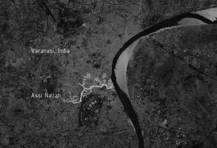
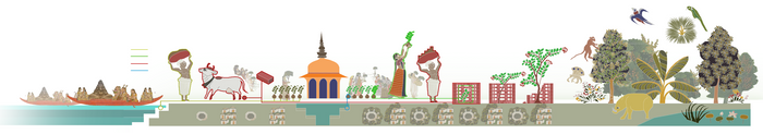
Varanasi was once known as the Forest of Bliss, or Anandavana. It has been a spiritual hub for Hindus and Buddhists over centuries and today is a bustling city with incredible pressures on its infrastructure. Located between the “Assi” nallah and “Varuna” river – the chapters of which also frame this publication, the city today faces urban pressures typical of modern Indian city including the degradation of traditional water management methods that have been halted and destroyed; the Neglect of talabs and rainwater management; mass deforestation, pressure and development focused on the River “front” while the inland interconnected water bodies are neglected; air and water pollution; public health and the increasing domination of private motorized vehicles dominating public spaces. At the same time, we do not see Varanasi as consisting of problems to be “solved” but rather as a way of thinking differently about an alternative conception of development driven by a reconnection with the productive lands, with water and social life at its center, rather than by the private car and developer prerogatives.
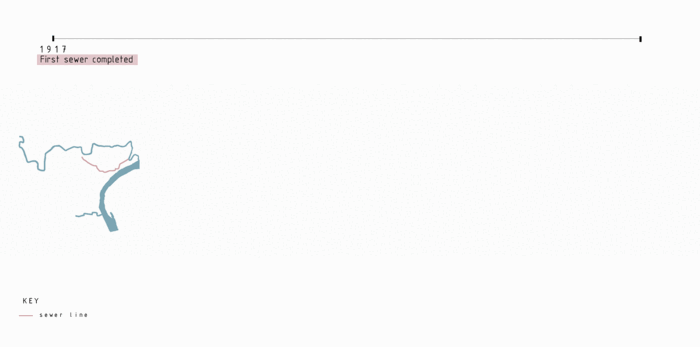
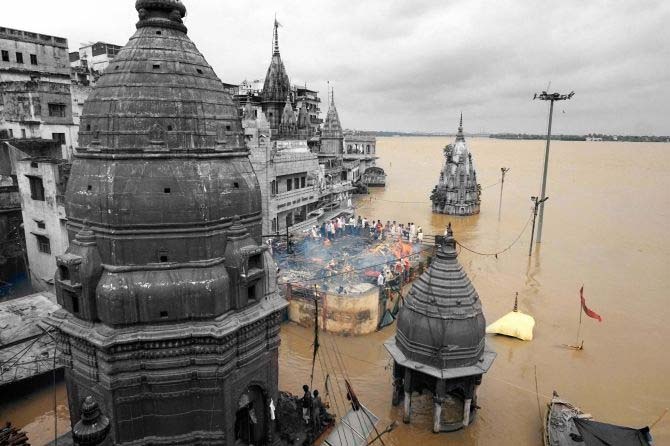
Like many cities in India and elsewhere, Varanasi is at the intersection of two water systems, as described by Prof. Dilip Da Cunha in this video: flows and holdings. The first system begins here with the River Ganges or Ganga as it is called locally. Varanasi is on the banks of this river. It extends via tributaries to points across the northern plains of India above Varanasi and deep into the Himalayas, drawing water from rain, melting snow and receding glaciers. It also extends via an infrastructure of pipes and drains to fields, industries, homes, and entire cities that draw water from it and return waste to it. This is a system that operates at a sub-continental, national and even international level, with issues that are out of the city’s control. Four major issues of concern are: waters rising with climate change beyond the already 30 to 40 feet that they do each monsoons; increasing household and industrial waste in the Ganges basin; increasing volumes of silt coming off the Himalayas that buries the ghats and fills the some temples on the ghats under many feet of mud and debris each monsoon; the project already underway to inter-link India’s rivers with siphons, dams, and canals promises to make the flow of the Ganges past Varanasi more unpredictable.
The second water system begins with the monsoons, a wind laden with rain that blows from June to September. It feeds tanks called kunds or talabs. These tanks are connected in series by their overflows, called nallahs. Once operated and cared for by local communities, tanks gave people a certain autonomy with the rain that fell in their catchment along with water from higher tanks that resulted in them making strategic relations with neighbors. Today this system is in disrepair, overwhelmed by a real estate pressures, breakdown of the local custodianship systems, water supply and drainage system that speaks the language of the river rather than the tanks, but also endangers the river. The two systems are divergent. It is a divergence that was encouraged by the English East India Company, which occupied Varanasi in the 1770s, and extended by the British who took over the governing of India in 1857 until India’s independence in 1947. Driven only by an imagination focused only on river hydraulics, they turned away from rain to rivers, constructing three sides to Varanasi: a) a “front” side on the river which is today the face of the city embellished with ghats populated by tourists and pilgrims who venerate the river ; a middle city that Mark Twain on a visit describes as a “vast mass of building, compactly crusting a hill, and is cloven in all directions by an intricate confusion of cracks which stand for streets;” and a periphery of communities around abandoned tanks, many of them built over, made into ill-functioning parks, or lying derelict and polluted.
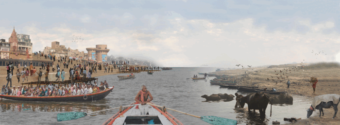
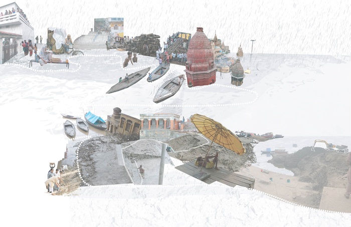
Varanasi is also at the intersection of two modes of habitation: sedentary and nomadic. The first mode of habitation ‘originates’ on the outer bank of an ancient bend of the meandering River Ganges atop an alluvial bluff subject to erosion by the river and many nallahs. Rising sharply from the river, this bluff slopes gently to the west. The settlement on it begins as intensely urban on the river with the stone steps of ghats that have over the last couple of centuries extended to cover the entire face of the bluff. Populated with shrines, these ghats are the site of several activities from the celebrations of festivals to religious rituals to everyday ablutions. The settlement transforms from these ghats to the west, eventually transitioning from a dense settlement into a rural hinterland of villages and agricultural fields. The second mode of habitation has occurred for centuries on the sand bar across the river. It is the inner side of the bend across from the ghats that typically ‘grows or shrinks with depositions by the river. Hidden with the rise of the Ganges during the monsoons being as much as thirty to forty feet, a vast portion of this bank is exposed when the river falls. It is a place for agriculture, grazing and the temporary settlements of nomadic pastoralists, craftspeople, musicians and others who crisscrossed the northern plains, more so in the past than today.
Columbia Faculty: Kate Orff, Dilip da Cunha, Geeta Mehta, Julia Watson
Special Advisors: Prof. Joy Sen, PhD, Prof. Arkopal K. Goswami, PhD, Prof. Bhargab Maitra (IIT), Students and Faculty of Banaras Hindu University
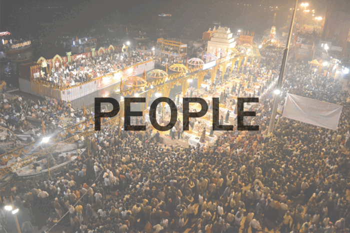
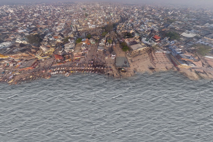
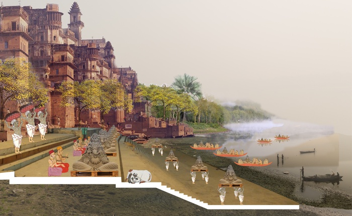
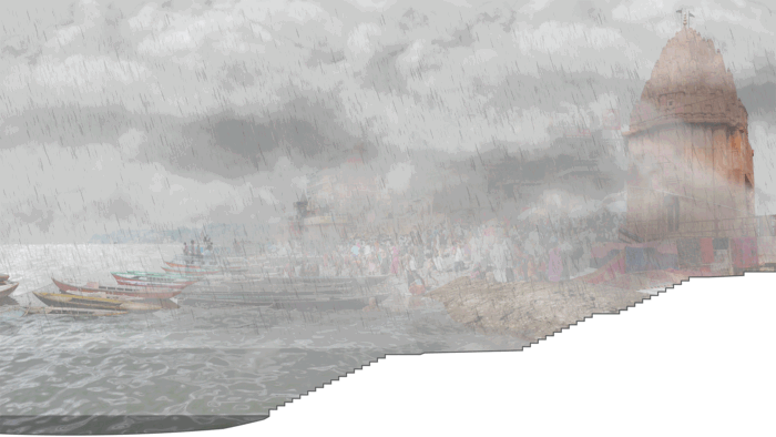
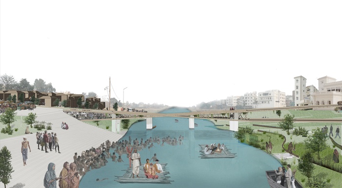
The sight of the majestic waterfront ghats, or steps leading down to the Ganges in Varanasi is unforgettable. From the twilight of dawn until after dusk, hundreds of thousands of pilgrims crowd along these steps to bathe in the sacred waters. Probably one of the most intensively used public spaces anywhere, the area is surprisingly clean and well maintained, unlike the rest of Varanasi, where trash heaps pile up in the streets, kunds (tanks), ponds and green spaces are neglected, and the overall level of city management leaves much to be desired.
The explanation for this sharp contrast lies in the matter of leveraging or ignoring the agency and civic engagement to the people of Varanasi. Over centuries, a system of maintenance for the ghats has been developed in which responsibility for every square foot is linked to a specific temple or family. It is a system of social capital that keeps the ghats looking as good as they do. Maintenance of the rest of the city is the purview of the government, which does not have the capacity or funds to do the job. This was not always the case. While the temples nearby usually cared for kunds, ponds and public spaces were the responsibility of the people who lived around these public assets. Responsibility for managing them was passed over generations of families, who were recognized at religious or secular processions and festivals.
How can we bring that sense of responsibility and caring for the urban commons back to our cities today? Kunds in Varanasi were clean so long as people depended upon them for water. The advent of tap water has resulted in people turning their backs on kunds, and allowing their drains and garbage to pollute them due to lack of adequate sewage systems or trash collection. The connection between residents and water has been severed and social networks and social capital of communities lost. Anthony Lovin, co-author of Natural Capitalism, argues that in order to curb air pollution from cars, the exhaust pipes of the car should be mandated to vent into the passenger cabin. The technology to make zero emission cars already exists, but manufacturers have no incentive to invest in this technology unless required to do so. Democratizing urban management, connecting people to the true impact of their actions, and developing methodologies so that people are able to help manage their environment is the key. The faculty in the studio challenged students to deeply investigate reviving the lost sense of connection between a people and their environment. To do so is the only way to build a sense of agency, responsibility for public assets, and a movement for grassroots city management in partnership with the government. People need to be empowered as citizen stakeholders, not as helpless victims of government inefficiency. There needs to be social accountability in the system, which is difficult to rely on just by replicating the systems of the past, as people are more mobile and travel across India and beyond. Challenges abound. Does our highly individualistic sense of modernity allow for such a community-based approach to the most vital functions of running a city? Does the toxic asymmetry of work-life imbalance allow time for individuals to contribute to community projects any more? What could be the mechanisms for enhancing social capital? Can modern social media and technology enable crowdsourcing of responsible citizenship? Can social capital be counted and accounted for, in a world where every thing is increasingly measured in terms of money? Might systems of incentivizing social good be more suited to the modern and more mobile lifestyles? Might pilgrims also have agency for improving Varanasi?
Urban design and architecture are social acts, so they must have a social purpose. Students’ explorations of the issues mentioned here are documented within the pages of this book.
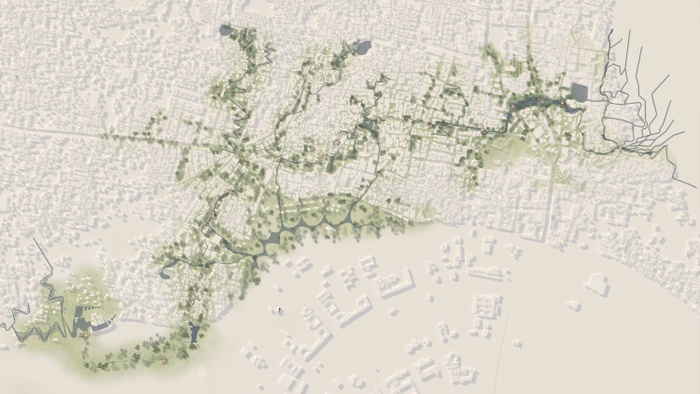
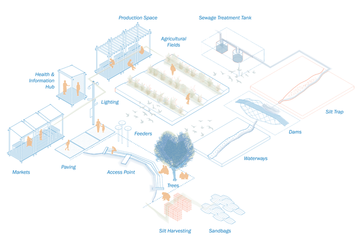
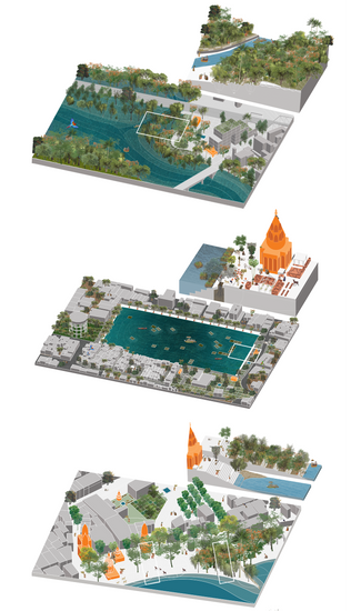
Our proposal aims to restore value to the Assi Nallah by creating a productive landscape along this waterway where communities can coexist.
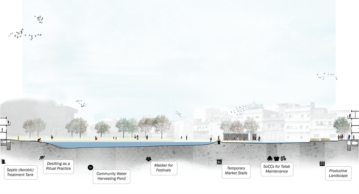
The overall design strategy is to adapt the Assi Nallah into an articulate system of holdings and flows with platforms and folds in the landscape that treats water biotically before it reaches the Ganges. First, we will encourage locals to clean up the solid and/or plastic waste in exchange for social capital credits. Then, locals will engage in landscape manipulations to create folds in the ground to slow down water flow for treatment in anaerobic platforms and filtration landscapes. Finally, these platforms can be a starting point for economic development like hostels, working spaces, or any other public needs.
Communities will serve as stewards of the reimagined Assi Nallah and through the concept of social capital, our design will allow communities to work together to maintain and benefit from the environment.


Project Introduction Video
What is a Nallah?
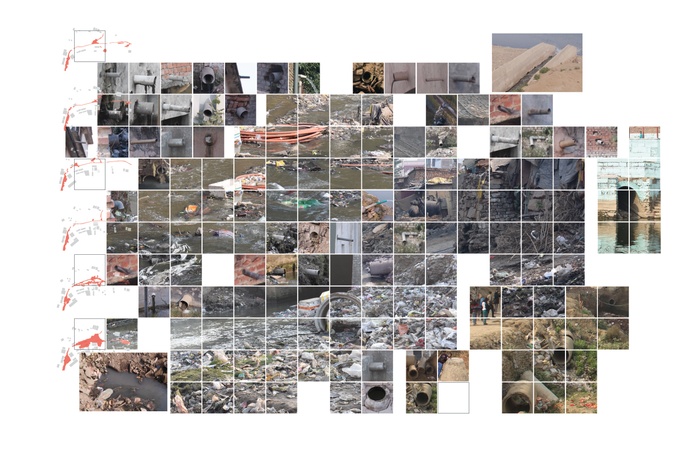
A nallah in Varanasi is currently an open drain that meanders through the city carrying sewage and runoff to the Ganges. These nallahs have become key conveyances in the city. Traditionally a nallah has served versatile functions, and in Varanasi a nallah was once the lowest portions of an agricultural surface, allowing water to gather and flow.


Assi Nallah vs. the Current Sewage Treatment System
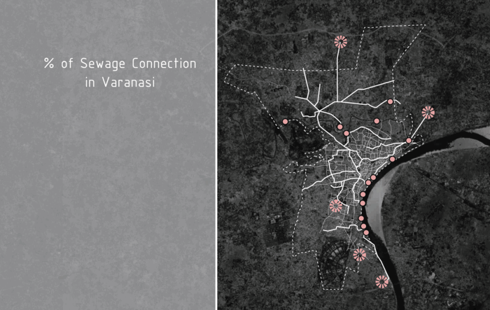
The current sewage system has an expansive network of drains to transport sewage to pumping stations. However, these pumping stations require continuous power to pump sewage to poorly maintained treatment plants. Large investments will probably not make this system successful. The current development of Varanasi’s sewage treatment system is neither strategic nor effective.
Under the government’s Ganga Action Plan II and Jawaharlal Nehru National Urban Renewal Mission (JNNURM) plan, Varanasi has planned huge investments in the sewage treatment system to pump waste away in non-strategic locations.
Varanasi’s existing sewage treatment system is stressed and only treats a small percentage of the sewage before releasing it into the Ganges. Most of the cities’ human waste is directed towards nallahs and not connected to a proper sewage system.
Proposal
Our proposal aims to restore value to the Assi Nallah by creating a productive landscape along the waterway for the community to benefit and coexist.
Overall Design Phasing
The overall design strategy is to adapt the Assi Nallah into an articulate system of holdings and flows, with the platforms and folds in the landscape that treats water biotically before it reaches the Ganges, and benefits the communities it flows through.
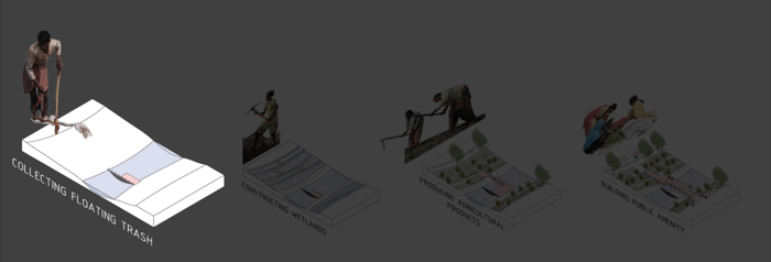
Collecting
First, locals will be incentivized to collect trash along the Nallah. They will earn social capital credits, which can be exchanged later for services. This is similar to the Carbon Credits or airline points system.
Constructing
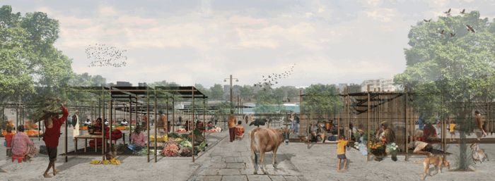
Once the trash is gone, locals can start to transform the land for productive purposes, and earn social capital credits. The incentives for this step will be to gain ownership of land for their homes and the use of public land on the edges of the water treatment bioswales for agriculture.
Producing
Third, the area will become a productive landscape for medical and agricultural products. Platforms will start to be introduced across or near the Assi nallah to provide working spaces for agro-processing and crafts.
Building
Last, new owners will be able to receive social capital credits for providing services on these platforms: maintaining public spaces, planting trees or any other services to improve their communities.
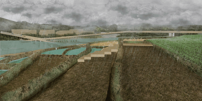
Design Language - Folds and Platforms
Through a series of folds and platforms that adapt to the hydrological flow, these interventions will have multiple functions and programs responsive to the people living along the Nallah. Some will be simple interventions while some will be more complex.


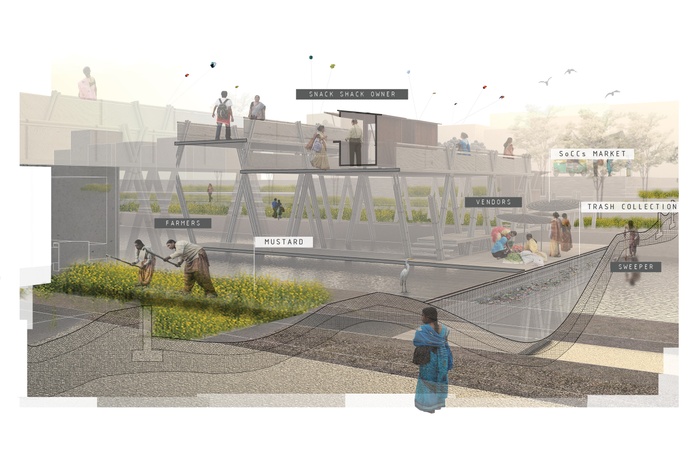
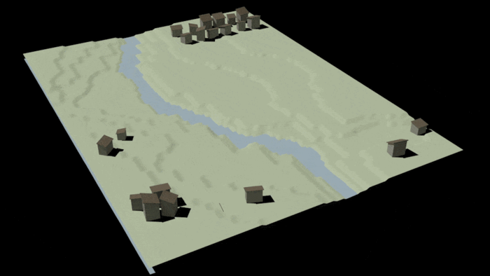
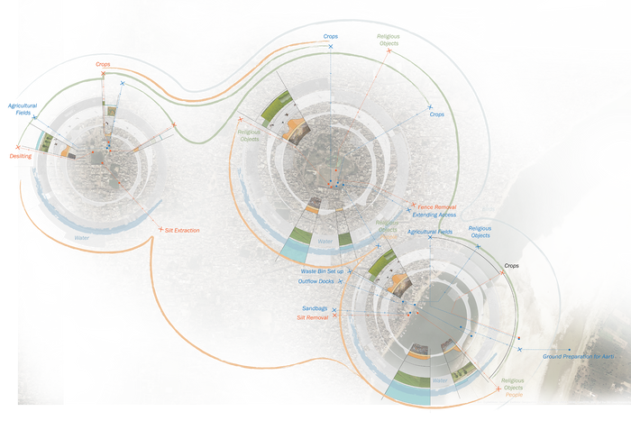
Site 1 - Assi Origin
At the origin point of the Assi Nallah, existing conditions and surrounding communities inform the design of the productive landscape.
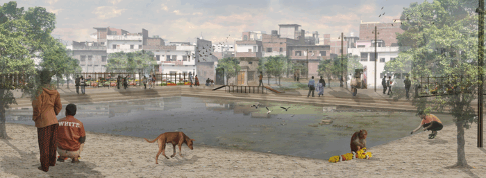
This treated wastewater and runoff water is channeled through the site into a larger water body that is designed alongs the open (maidan) spaces. Water from this water body filters into the existing kund (tank) and filters out to become the starting point of the Assi Nallah.
Our design strategy is to first complete building up the existing abandoned Kund to allow communities to conveniently use this water body for washing and fishing. Nomads, vendors, and the surrounding community can occupy the open space around the kund.
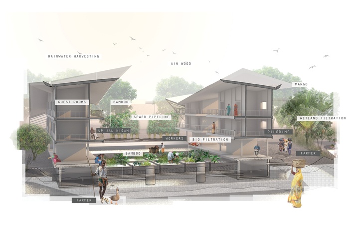
These platforms of biotic sewage treatment infrastructure are expected to be owned and maintained by Uttar Pradesh Jal Nigam, an entity that currently has jurisdiction over the State’s sewer system. Farmers and maintenance workers are expected to work, on their respective sites together, to maintain this water treatment system.
On top of the platform, we propose programs such as a dharamshala (Pilgrimage hostel). These pilgrims can become a continuous source of funding for this system. Industries can be generated from the productive landscape such as food processing, bamboo crafts, Ain wood production, medicinal plant production, etc.
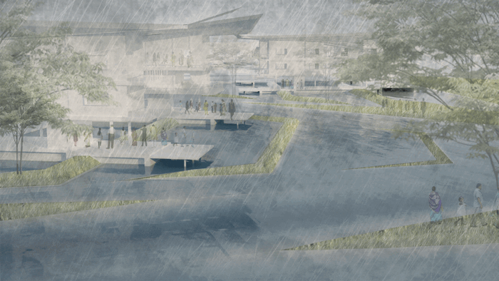
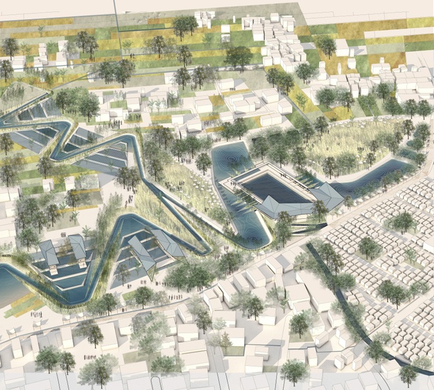
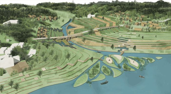
Site 2 - Assi and Ganges Confluence
At the confluence of the Assi and Ganga, this project celebrates this holy intersection by transforming an existing park into a delta of temporal productive landscape- for use by pilgrims and able to accommodate the flood waters of the monsoons.
The ghat area has been designed as a series of landscape folds that filter runoff before it flows into the Ganges River. These folds also create terraced platforms for temporal agriculture.
The landscape folds in between the the existing communities and weave in to occupy the new ghats, activating the adjacent public spaces. Since the Assi Ghat area is a popular location for guest houses and many tourists to go, a vibrant public space can attract tourists that can add to the local economy and become a source of funding to maintain these ghats.

3D Exploration
Through CNC modeling we were able to explore different folding typologies in the landscape.
If We Want a Clean Ganga, We Need to Start with the Nallahs
With urban nallahs running into it, it is not surprising that with the steep rise in urban population has made the Ganges, which is considered as a holy river by millions of people, among the most polluted in the world. It receives three billion liters of untreated waste everyday via nallahs like the Assi. The Indian Government, along with numerous foreign and local entities have invested considerable amounts of money, time and infrastructure over the past 30 years into cleaning the Ganges. However, their solution of building large-scale infrastructure to intercept and treat sewage along the 2,500 km-long river is not resilient, effective, and lacks social benefits. A proposal for an alternative and more robust strategy is provided here.


Project Video


Due to Varanasi’s religious importance and the number of festivals that occur in different seasons, the population fluctuates throughout the year from 1.2 million to 6 million. 1 This flux in the number of people consists of pilgrims, tourists and nomadic groups. Nomads and workers from surrounding towns also come to Varanasi in order to sell their goods for rituals, and use Varanasi as a ground for living and production. The flux and flow through Varanasi is not limited to people, but also to the annual rainfall which changes the landscape, the celebration of festivals, migratory birds that come from Siberia from November to March, and seasonal flowers that are used in festivals.
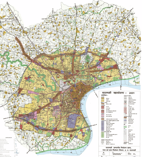
The Varanasi Development Authority has prepared a 2031 Master Plan that is meant to expand the city to accommodate the growing population. Our project challenges the 2031 Master Plan by looking at Varanasi as a pulsing city rather than static and linear growth entity, where public spaces should be flexible, adaptable and resilient to accommodate the intensifying seasonal flux of people, flora and fauna.
Project Video
Actors in Flux
We analyzed the layers and flows in Varanasi and linked the flows to four actors: the people that come for festivals, the fauna that is grown nearby, the migratory birds that occupy the Ghats and the Sandbank, and the Ganga River’s dynamic edge that defines the Ghats and the Sandbank.
Elements and Beneficial Transactions in a Socio-Ecological Community
We analyzed the flow of our four actors through Varanasi, to understand where they originate, and the beneficial transactions between them, and noted the following:
- The pilgrims and tourists coming from all over the world are a major trigger for commercial activities in Varanasi. The nomadic Banjara tribal population coming from Rajasthan also add to it.
- The migratory birds that fly from Siberia to the wetlands in Varanasi and the Ghats create an attraction for bird watchers and therefore an income source for boatmen.
- The diverse flora species that grow around Varanasi include native species as well as those from South America, Australia and Europe.
- The flow of the Ganga River that causes dynamic changes in the Sandbank due to Monsoon and seasonal changes


Cycles of Flux
We have traced the cycles of our actors throughout the year in Varanasi, and how they fluctuate in different seasons in relation to cycles of monsoon, migration, cultivation, and celebration. The flux of birds occurs between November to March. Festivals that attract tourists and pilgrims coincide with harvesting seasons to celebrate good harvest, and water affects them all including festivals and crops.


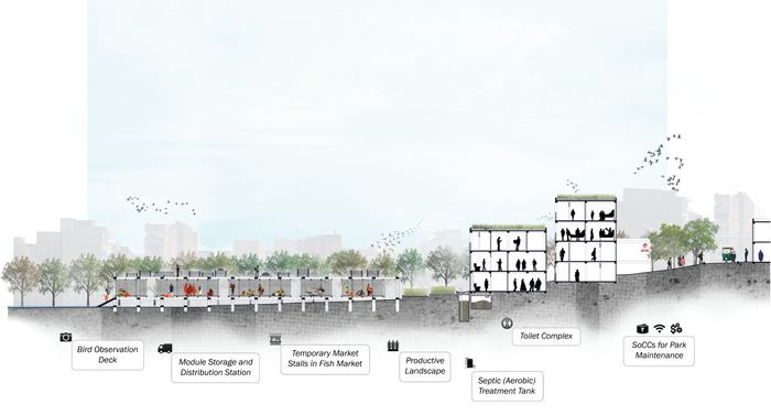
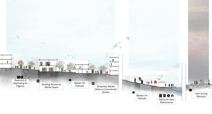
Adopting the Maidan Concept to Accommodate Flux
Our proposal adopts the concept of maidan, which is an open space that allows for flexibility in program, porosity, density of users, and adaptability to different seasons. Talabs, parks and the edges of the Ganga River are common public spaces in Varanasi. They are identified as potential maidans which can be transformed into seasonal, adaptable and resilient spaces to absorb the intensifying flux.


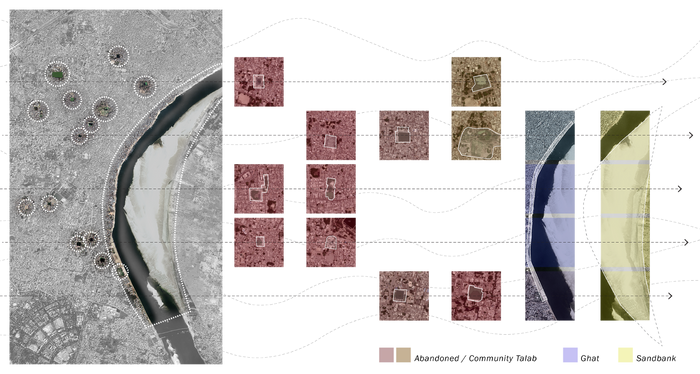
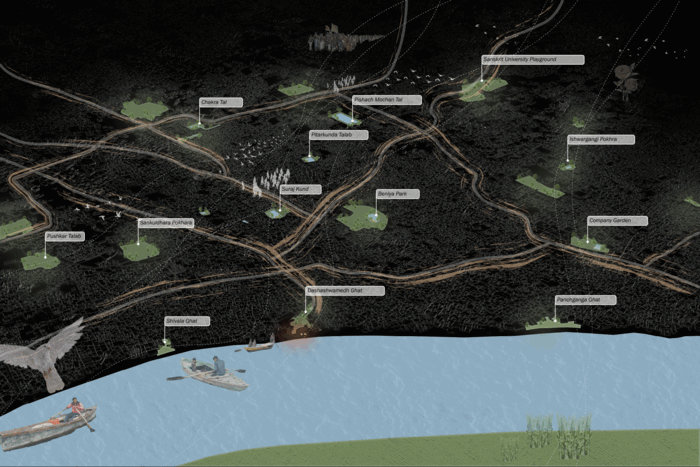
Site Typologies
Three types of flexible public spaces, where the flux is most concentrated, were chosen to test how they perform in relation to the calendar. These are Chakra Tal (pond), Beniya Park and the Ganga River’s dynamic edge. Design strategies will be developed for each site typology, which can be used to transform similar public spaces into maidans in other locations too.
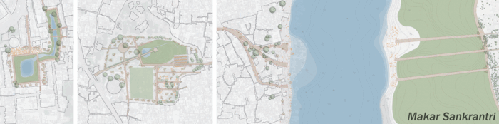
Maidan Infrastructure
The infrastructure of a maidan consists of two types, permanent and temporary. The permanent infrastructure has been designed to appropriate the sites to be adaptable and flexible. It is designed to provide direct access from the city fabric to the maidans by removing fences and physical barriers, and enabling the maidan to become an extension of the pavement from the alleys. Dense trees are planted along the periphery to define the maidans to prevent encroachment and provide shade. The temporary infrastructure is designed to allow the maidans to perform in response to different seasons. A kit of parts that can be aggregated and amplified to accommodate the flux of religious tourists has been proposed to create this temporary infrastructure. The material palette of the infrastructure is based on locally sourced materials that can be self-organized and locally managed.
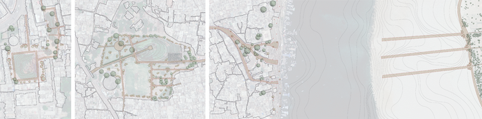


Infrastructure Performance in Different Seasons
The performance of each site was explored for different seasons and festivals, especially Makar Sankranti (January), Shravan Mas (July-August) and Dev Deepawali (November), to show how the infrastructure can perform at times of low water levels, high water levels and when there is a large number of pilgrims and tourists respectively. The kit of parts allows the infrastructure to be moved between the maidans depending on the seasons and the needs.
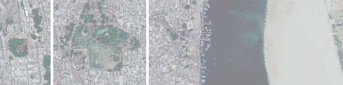
Chakra Tal as a Maidan
Chakra Tal is currently an abandoned natural pond that once was an important social space for communities and a flourishing habitat for wildlife


Beniya Park as a Maidan
Beniya Park is currently occupied by different groups of people. Nomads use it as a temporary shelter, flute makers use it as a shelter and production space, and residents around it use it as a playground. The park is currently enclosed and fenced separating it from the surrounding urban fabric with an unfinished abandoned structure that was supposed to be a fish market and is currently used as a toilet.


Dashashwamedh Ghat and the Sandbank as Maidans
In their existing condition, Dashashwamedh Ghat and the Sandbank lack resilient spaces and infrastructure that correspond to seasonal changes. Physical barriers along the Ghats prevent continuity of public spaces and soiled water outflow are currently contributing to the pollution of the Ganga River.


Material Flows Through Maidans
The maidans are proposed to operate as an expansive network to accommodate the flux of materials and services to respond to the users’ needs and to maintain the performance of the sites. Public transportation may be provided to further connect the maidans where feasible. These networked maidans will ease the mobility of the four actors through the sites. Transient populations will have information to use these maidans. Crops grown in the community gardens around the talabs can be moved to the markets in Beniya Park and the Ghats along this network. During monsoon, the displaced population from the Ghats can move along this network to shelters and markets at Beniya Park.
Conclusion
In order to prepare Varanasi as a pulsing city that accommodates the flux, public spaces can be made resilient by making them flexible, adaptable and seasonal, i.e. like maidans in the true sense of this space typology. This is essential for the future of Varanasi as the flux of people intensifies due to increasing demand, and the water level rises even more due to climate change.


Project Video
Incremental Floodplain Development
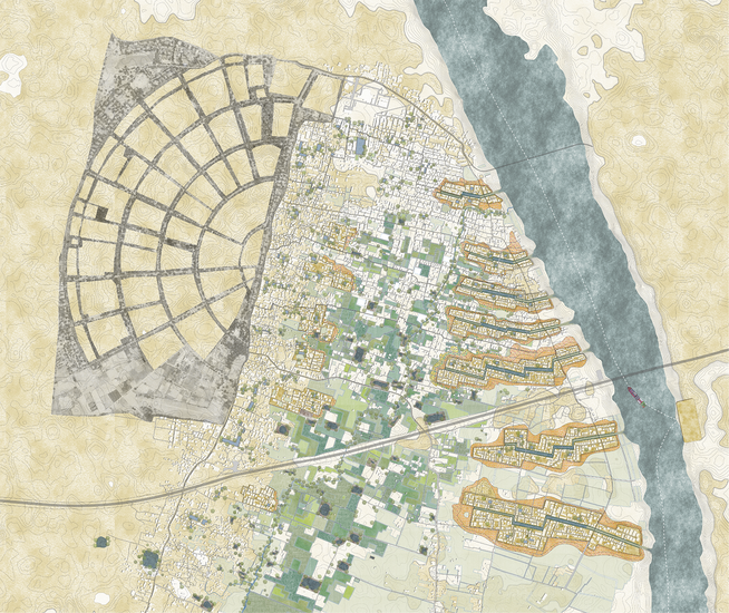
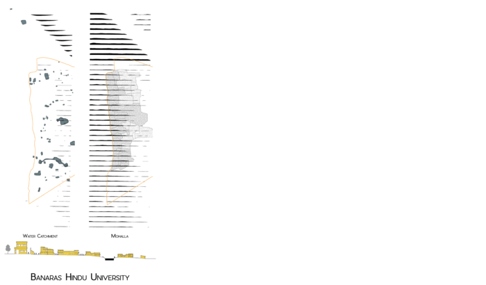
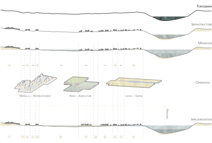
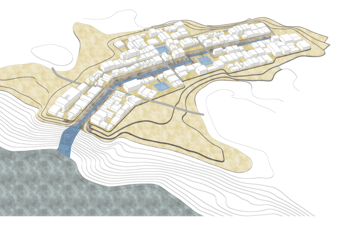
In the floodplain site between the Ganges River, the Ring Road, and Banaras Hindu University, we propose a settlement strategy of ‘fingers of high ground’ by using a combination of soil from cut and fill operations and dredged river silt to build the fingers. This will be followed by an incremental building strategy on top of the fingers based on the mohalla, a prevalent neighborhood typology in Varanasi. The low-ground areas between the fingers will become capable of draining water to the river during monsoons while serving as ground for urban agriculture during the rest of the year. Infrastructure and transportation is also proposed along the spine of the fingers, which will enable people formerly living on the low-grounds to have better connections with the city and its infrastructure, and live with resilience, harmony and improved economic opportunity
What is Floodplain Urbanism?
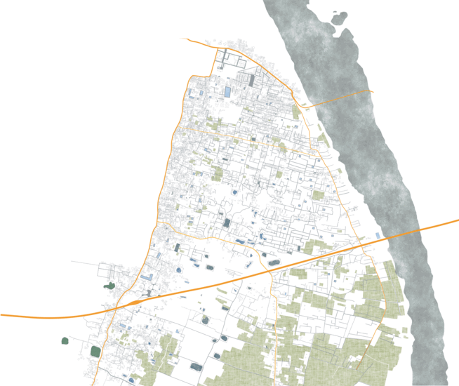
Meander is a winding curve or bend in a river that results from both erosional and depositional processes. It creates low-lying areas on either side of a river i.e., a floodplain. Currently, the floodplains along the Ganges River are unsuitable for development due to their geographical condition.
Even the Varanasi Master Plan of 2031, which proposes to expand urbanization, does not deal with the low areas which flood each monsoon. The disregarded floodplain causes hardship to the poor and marginalized people who settle in the informal settlements in the floodplains due to lack of choice.
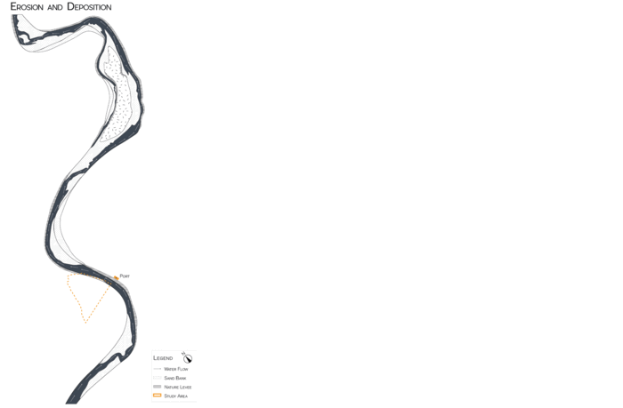


What is the existing condition of the site?
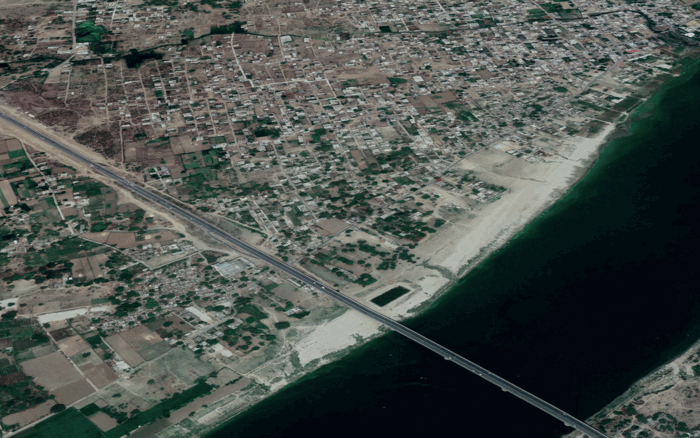
Across the Ganges River from the site a major project is underway: the development of a multi-modal terminal on National Waterway 1 that is expected to serve cities from Allahabad to Haldia. Along the stretch of this 1620 km project, Varanasi is one of the major cities. The key benefits from this terminal is the sand and silt that will be dredged annually for the cargo ships to traverse the river. With the large amount of river silt, we propose to build fingers of high-ground to improve living conditions in the floodplain of the Ganges River. 1
Our site is the low-grounds between the Ganges River, Ring Road highway, and Banaras Hindu University. Each one of these have different development characteristics of low and high grounds.


The Ganges River, Ring Road highway, and Banaras Hindu University is the geographical high-ground infrastructure adjacent to the low-ground. Distinguishing High-Ground and Low-Ground defines the incremental operation strategy that could be applied to the low-ground.
*Three High-Ground + Low-Ground *
- The Ganges River deals with levee [high-ground] built from sand dredge, that deposits and drains the Ganga [low-ground]
- The Ring Road highway bund [high-ground] helps to connect and expand through agriculture [low-ground] and its market.
- The Banaras Hindu University is surrounded by mohalla [high-ground] settlement, a typical community formation that involves religion, occupation, and social class in Varanasi, that structures itself around an infrastructure such as, water catchment [low-ground].


“How can we design to live with Ganga River in harmony?”
Resilient + Incremental Design Strategy
As the current low-ground sits below the monsoon flood level, the communities living there have to relocate themselves annually. To make a resilient living space in the low-ground area, this project proposes an operational strategy of three high-ground and low-grounds.
“How can we incrementally develop the low ground area to become resilient?”
Once the three operations – levee + Ganga; bund + agriculture; and mohalla + water catchment – are applied, the low-ground area can be improved incrementally by building high-ground for habitation from dredged sand and using mid+low-ground for seasonal agriculture to enhance the economy and ecology of the area.
The project proposes to begin with a finger of high ground across from the port development, then expanding both ways from there with a high-ground mohalla typology and low-ground agriculture. During the monsoon, the low lying area will drain out the flood water while leaving high-ground mohallas dry and resilient.
With high-ground formation made up of dredged sand and silt, the new urban fabric will regenerate incrementally using a mohalla typology around water catchment structures. The mid-ground will support terraced agriculture. And the Low-ground will drain out monsoon water during the wet season and support seasonal urban agriculture during the rest of the year. It will create a new source of income that will turn informal communities into “communities in formation”.
Planning in Varanasi is done by the Varanasi Development Authority. This project strategy will give them a way to develop the floodplain. Once the high-ground is built, the demand for real-estate will rise. This will justify building high-ground with the large amount of annually dredged silt from National Waterway 1 development. However, it is important that they ensure that the poor are not pushed out of this area by real estate pressures.


Conclusion
The proposed ‘fingers of high-ground’ on the low-ground in Varanasi can become a prototype for the floodplain all along the Ganges River. This model of development provides an opportunity for the vulnerable areas to house marginalized populations. The High-Ground + Low-Ground approach to urbanism can improve economic opportunity as well as bring resilience to settlement in the Gangetic Plain.


Project Video
Anandavana
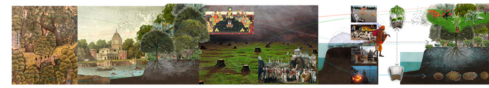
Varanasi was once called “Anandavana”, meaning Forest of Bliss. This ancient place has invited millions of pilgrims to share in its spirituality and connect with it through the forest. Today, this magical landscape of the forest is lost, only seen in historic images.


The loss of the forest is a tragedy for those who love Shiva and care about the pollution of his sacred body.
But it is possible to revive Anandavana.
Water-Spirit Connections
Recovering the Relationship Between Nature and Sacred Rituals
Hinduism centers on respect and care for nature and rituals. Pilgrim routes have always followed water bodies, giving them an importance and meaning.
Focusing pilgrims’ energy on care for nature can have an amazing impact on the ecology that surrounds them. This is a great opportunity that benefits from the number of visitors Varanasi receives each year, and will likely receive in future.


The New Sacred Route
We propose a new pilgrim route that connects all the existing ones. Pilgrims will enter the city through Dashashwamedh Ghat, follow a course to the Varuna, and return along this river to the Ganga River.
This route abstracted as a straight path in this drawing serves as a ground for initiating a forestation strategy. We visualize the forest extending from here like fingers toward the countryside.
The three sites of intervention:
- Ghats: Fertile soil deposited by the Ganga River (especially after Monsoon) will be gathered, sculpted and carried to particular sites through rituals by pilgrims.
- Kunds: Schools and temples surrounding these tanks will coordinate tree nurseries as well as collection of cow dung and clay to produce bricks and pots.
- Varuna: This will be a site of community-based nurseries involved in transplanting trees along the river and protecting trees with brick lattices.
Sciences Behind Rituals
We work with a diverse palette of native trees and trees that will benefit people and the ecosystem. The more diverse the trees the better. The output of forest nurseries involves a complex coordination of plant growth with the calendar of festivals in order to leverage the most for the propagation of trees.
Universities can be in charge of coordinating forestry practice and social rituals.
Mitigating Severe Flooding and Habitat Depletion in the Gangetic Plain
The forest will start to grow from our proposed route toward the countryside aiming to ultimately achieve a single patch of forest cover in the future for the whole Gangetic Plain.
Conclusion
With a constant stream of local resources including fertile sediment, rain, cow dung, clay, and one million annual spiritual pilgrims visiting, Varanasi has the potential to become the forest it once was. The energy and dedication of pilgrims can be leveraged to propagate trees through social ritual coordinated by community-based agencies, spiritual leaders, and educational institutions. This forest aims to provide various city needs needs by infiltrating the current infrastructural system, changing the matrix, localizing resource management, building community, and starting a global ecological revolution that reclaims our neglected ecology.
1 Relief and Rescue Operations Continue in Flood Hit Uttar Pradesh and Bihar. Pti - https://www.financialexpress.com/photos/business-gallery/354933/flood-in-patna-allahabad-ndrf-air-force-continue-relief-and-rescue-operations-in-flood-hit-uttar-pradesh-and-bihar/2/
2 A festival of Krishna: featuring Under the Kadamba tree, paintings of a divine love and Ateliers of love, a film on DVD, a journey of poets, painters, and patrons Harsha Dehejia - Lustre Press, Roli Books - 2008
3 A festival of Krishna: featuring Under the Kadamba tree, paintings of a divine love and Ateliers of love, a film on DVD, a journey of poets, painters, and patrons Harsha Dehejia - Lustre Press, Roli Books - 2008
4 A festival of Krishna: featuring Under the Kadamba tree, paintings of a divine love and Ateliers of love, a film on DVD, a journey of poets, painters, and patrons Harsha Dehejia - Lustre Press, Roli Books - 2008
5 Select views in India: drawn on the spot, in the years 1780, 1781, 1782, and 1783, and executed in Aqua tinta William Hodges - Edwards - 1786
6 Jayaswal, Vidula & Shukla, Uma. (2016). Summary and Deductions. 317-331
7 Benares illustrated. James Prinsep-O. Kejariwal - Pilgrims Pub. - 2009
8 Singh, Rana. (2017). Sacredscapes of Banaras (Kashi/ Varanasi): Cultural Landscape and Cosmic Geometry. Context: Built, Living and Natural [ISSN: 0973-502X; DRONAH, A-258, South city 1, Gurgaon, HA 122007, India]. 13. 11-22
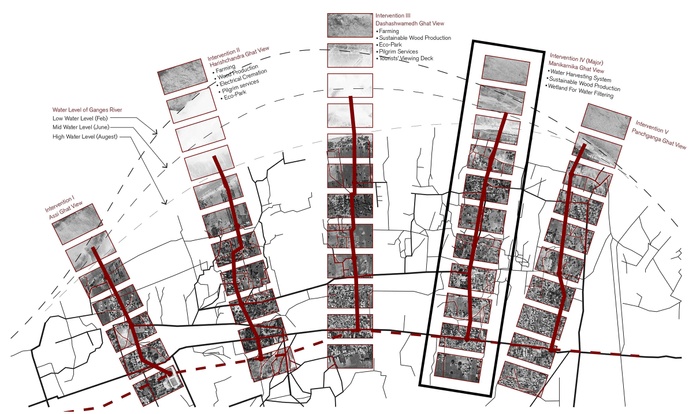
The Aggregation of Transactions
Project Video
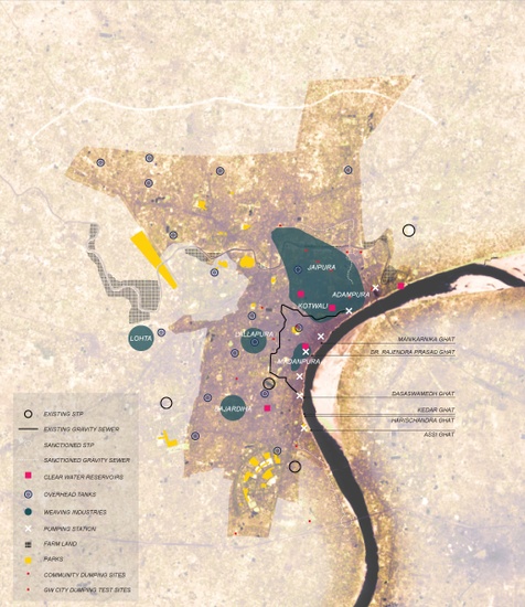
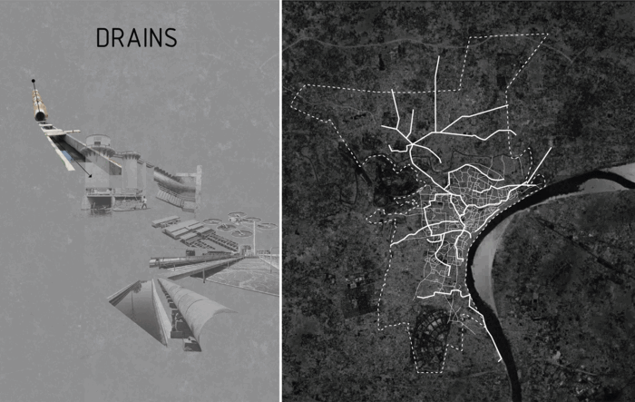
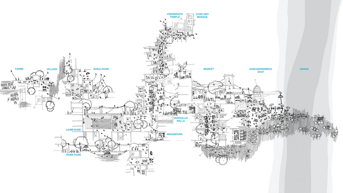
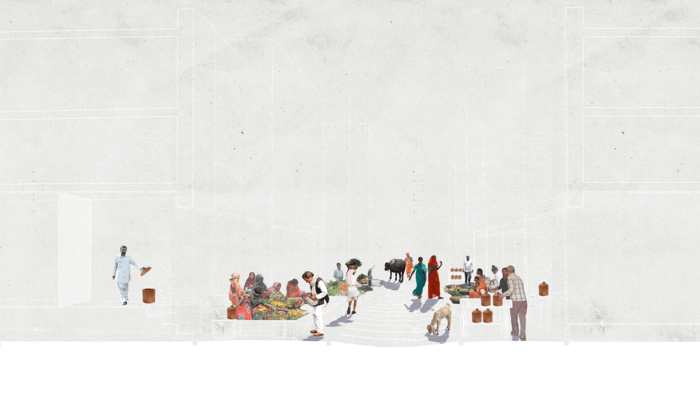
Existing Water Infrastructure and The Physical Region of Boatmen, Weavers and Farmers
Looking at the locations of existing economies and their physical relationship with open space and existing water infrastructure, we are able to determine the agency and reach of transactors.
Reintroducing Externalities
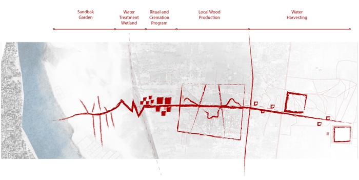
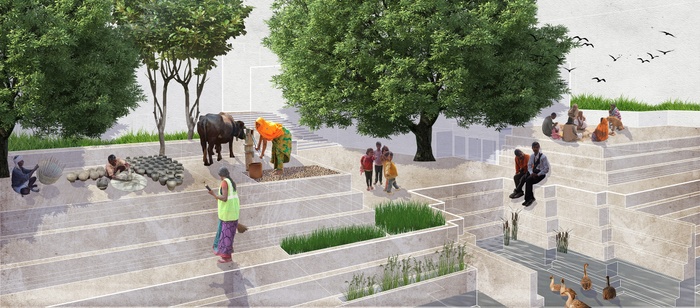
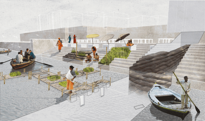
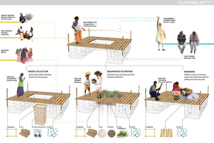
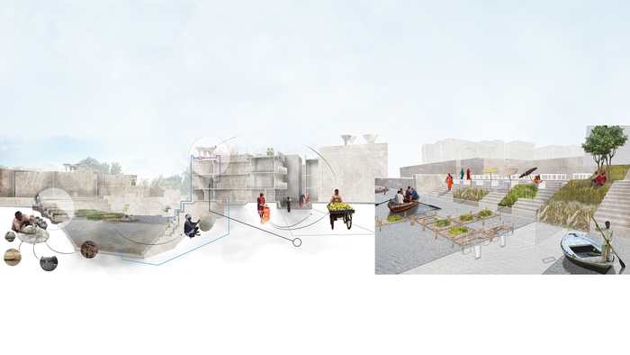
Organic waste, mud and sediment, waste material from industry such as plastic, and skilled labor such as weaving and farming all become essential to the network of new transactions. Using monsoon mud deposits as a ground building material, we will be able to increase water absorption throughout the city and soften the edges of the ghats by creating slivers of green spaces that become retention sites and opportunity for filtration. The base of the ghats are then extended into the river through docks kept afloat by recycled waste. These docks contain space for aqua-agriculture. Through gravity-based water filtration, the entire city becomes a means of addressing waste management and water quality.
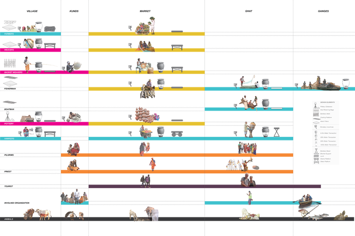
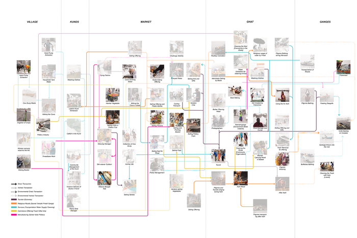
Transactors and Their Tools
Unfolding the activity involved in these transactions allows us to understand the skill-set and existing incentives for local labor. The territorial ranges and materials used in this labor are then mapped out to identify the externalities created as a byproduct.


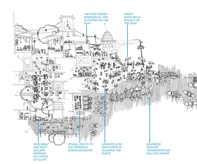
Isolating Transactions in the Market
The market is the location of transactions that are very informal. Yet each involves a particular sequence of events that include where materials come from and where externalities go. Here, we can facilitate transactions in more efficient ways while providing the opportunity for upward mobility of those who rely on these economies.


Softening of the Ghats and the Creation of Public Space
It is vitally important to address the collapse of Varanasi’s ghats caused by erosion from the flow of the Ganges, particularly during the monsoon season. We do this by ‘softening’ it in parts with interventions that deploy the craft of weavers, boatmen, farmers and potters. It provides them new opportunities for employment in parallel with new skill sets that they may require and access to education through social credits. It also creates accessible public space for everyone’s use.


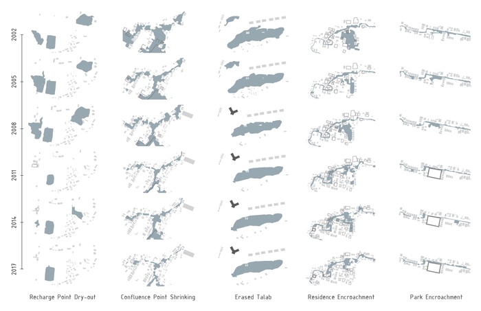
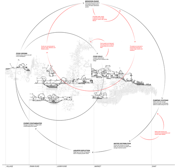
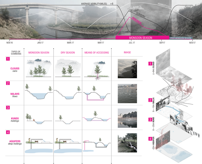
Water in Varanasi is facing a “tragedy of the commons” 1. It suffers from overexploitation and severe pollution.
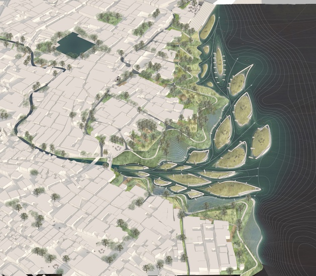
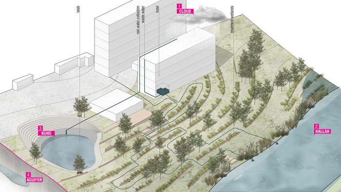
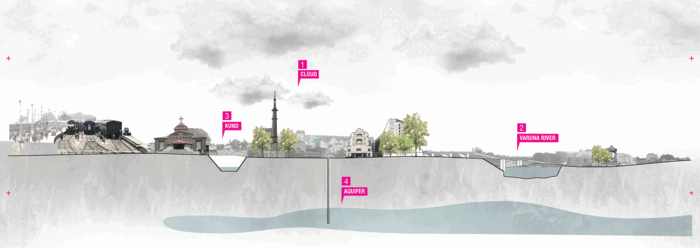
Working with water in four “commons”—clouds, nallahs, kunds and aquifers—we propose to turn Varanasi around, beginning with one of its most significant landscapes: the Varuna River. Seen as a tributary of the Ganges and now made into a drain through misuse by the city, we see it as an opportunity to transform the city from a land-based entity to one that organizes around its water commons. Identifying four water commons in Varanasi and looking at them in different time frames, we recognize that each has its own rhythms and encourages its own means of accessing and relating to water. The project explores and enhances the relationship of these four commons, allowing them to operate in a sustainable system, one that takes advantage of fluctuations in rainfall, humidity, water table depths, saturation of soil and flows.
Four Commons aims to restore the value of Varuna as a spiritual spine, a cleansing biotope and a driver of Urban Design.
What is a “Tragedy of the Commons”?
When individuals overexploit and pollute a shared-resource system according to their own self-interest, behaving contrary to the common good. This behavior leads to the loss of the resource.
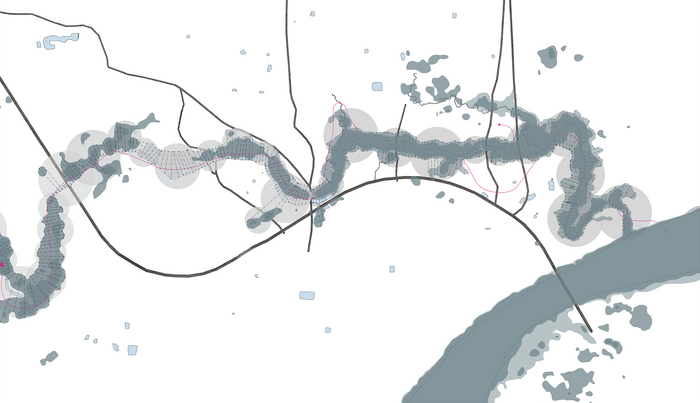
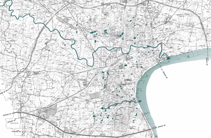
From Urbanization to River-ization
Varanasi is situated between two water commons: The Varuna River in the north and The Assi Nallah in the south. The current “Varanasi 2031” Master plan proposed by the authorities is based on ring roads; it does not take into account the actual ground truths of the city’s rich landscape such as natural water bodies, whether in the form of flows or holdings. As a critique of the 2031 Master plan, this project proposes a flip in the way modern planning is practiced, by leveraging the natural water resources to become drivers of planning, beginning with The Varuna river.
Four Commons
Water Commons at a regional scale
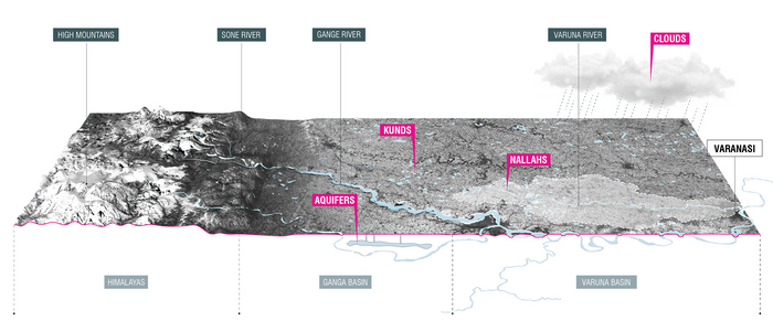
What are the Four Threatened Water Commons in Varanasi?
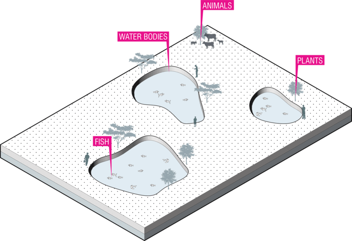
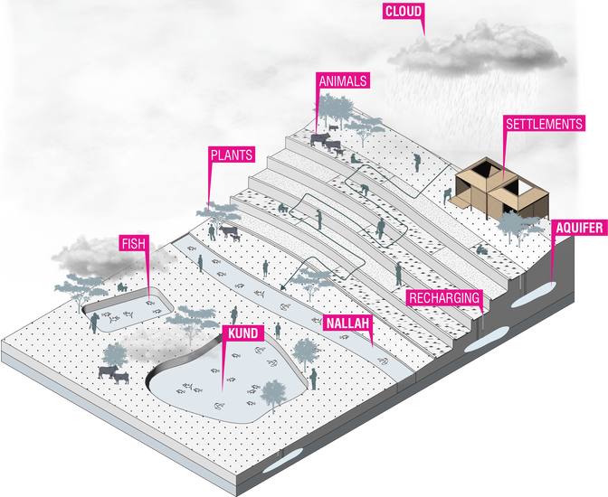
The project identifies four water commons in Varanasi: clouds (rains), nallahs (flows), kunds (holdings) and aquifers (deep holdings). We designed this system to meet the residents’ needs for water and prevent the floods that frequently occur in the city. The project Four Commons aims to construct an environment that nurtures a diverse species of animals and plants, and one that cultivates the commons as the future of the city.
How Do We Turn Varuna into a Cleansing Biotope?
The project’s various operations revolve around understanding the conditions of high-ground and low-ground along the Varuna River, working with the opportunity of the middle-ground.
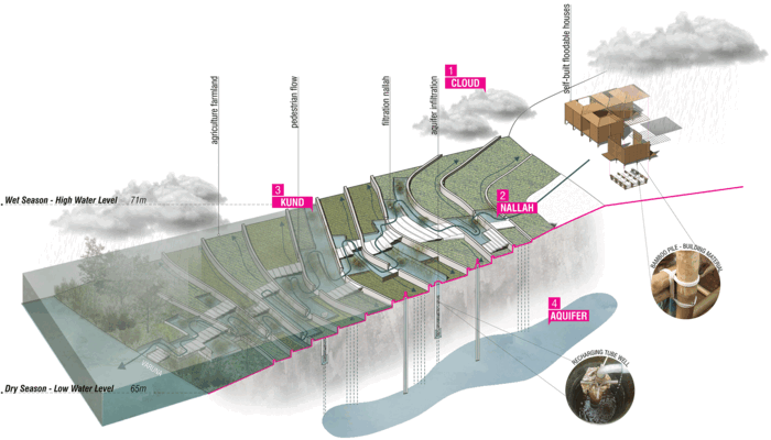
Productive Terracing
Productive Terracing places community settlements on higher ground, while the middle ground becomes terraced farmland that carries with it water run-off guided through filtration nallahs. These waterways will filter water run-off, and at some points, also serve as a holding system creating kunds or ponds along the way where clean water is stored for irrigation as well as domestic purposes.
During monsoon season, Varuna’s water level rises up, which will cover a large portion of the terraces where water will be held to fertilize the farmland. This operation also proposes tubewells as a ground-water infiltration process to recharge the aquifers. Water stored in kunds can fill the recharging tubewells to help water make its way underground.
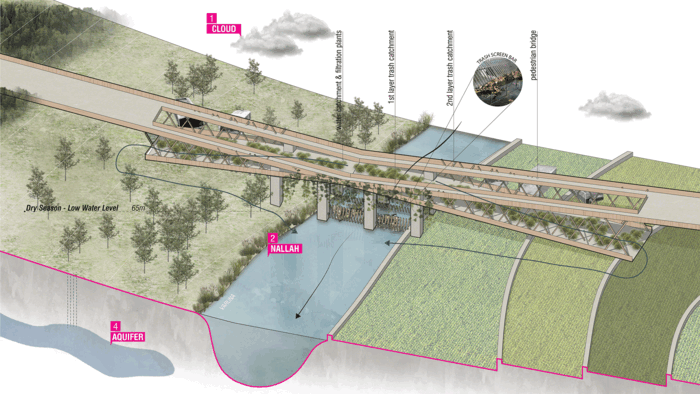
Trash Catchment
Trash Catchment proposes to look at a bridge not only as means of crossing, but also as an infrastructure that helps cleansing Varuna, as a trash catchment operation. The trash screen bar at the water surface level is proposed as the first layer of catchment during dry season, whereas there is a second layer of trash screen for wet season between the two levels of the bridge.
Water Treatment System
Another operation proposed is the water treatment system. We propose constructing wetlands along the Varuna River which can treat the grey water that is discharged by the surrounding buildings as well as water runoff. At the same time, we propose taking advantage of the roofs of buildings for harvesting rainwater which can be stored in nearby kunds.
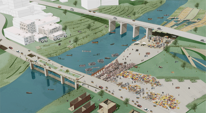
The Crossing: a Cultural Node
The Crossing is a site in Varanasi with a large area of settlement between the railway track and the Varuna River. We have identified the actors who can be potential stewards, including for example, the cultural and educational institutions as well as the religious community around the area.


Proposed Concept
After looking at the topographical condition, the high ground vs. low ground and water flow, we come to the conclusion that the city has turned its back to the Varuna River. Our concept proposes to leverage the Varuna to once again become the front of the city. With this goal, we have designed a series of holdings in the form of talabs (ponds) as well as kunds (tanks) where water flows through a filtration nallah (waterways) that starts from the railway tracks, situated on a higher level, down to the Varuna River. The idea is to be able to filter and store water at different locations. At the Varuna, we propose to soften the river’s edge to create different ecological habitat areas as well as constructed wetlands that help in bioremediation-wastewater treatment for the wastewater that is discharged by the buildings along the river.


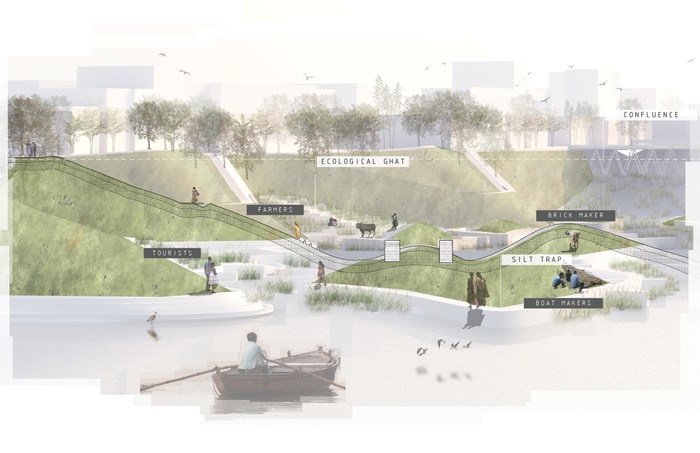
The Confluence (As an Agricultural Node)
The Confluence is where the Varuna meets the Ganga, and is bordered by existing seasonal agriculture and informal village settlements.


Proposed Concept
After looking at the topographical condition, the high ground vs. low ground and water flow. We propose to thicken the Varuna at low points, in order to provide ecological habitat areas, while placing the eco-community settlements on higher-ground to make them more resilient. Seasonal terraced agriculture fields have been proposed in the middle ground. During dry season, the middle ground can become productive landscape and during monsoon season, it can hold water at the terraces to keep the soil fertile and to serve as a way to recharge the aquifer. Filtration nallahs (waterways) are designed according to waterflow analysis, so all sewage as well as stormwater can get filtered before entering the Varuna. The project includes various urban actors such as farmers as well as fishermen in the design process as potential stewards.


Conclusion
We envision the four commons intersecting in different ways, by different means, and at different times to restore the value of the Varuna River as a spiritual spine, a cleansing biotope, and a driver of Urban Design in Varanasi. This Four Commons project suggests considering water commons as the future design strategy of Varanasi, and recognizing their value as drivers of regional planning. The residents of Varanasi will, then, benefit from a water oriented city where they will have access to clean water for drinking, irrigation and cattle rearing purposes in an ecological environment that can once again hosts a diverse species of animals and plants like it used to.
Project Video
1 Garrett Hardin, ecologist, 1968 published article in Science.
2Image Credits: Kate Orff. https://goo.gl/maps/wZ2AEfE7fax

Published By:
Columbia University
Graduate School of Architecture, Planning and Preservation
Urban Design Program
411 Avery Hall, 1172 Amsterdam Avenue
New York, NY 10027
United States of America
Columbia Faculty
Kate Orff, Dilip da Cunha, Geeta Mehta, Julia Watson (Aqaba Site Faculty: Ziad Jamaleddine, Nora Akawi, Petra Kempf, Laura Kurgan) Roving Engineer: Jason Loiselle
Columbia University Students
Reimagining the Assi Nallah:
Jesse Hirakawa, Xiaofei Huang, Marnfah (Fah) Kanjanavanit, Shihhao Liao
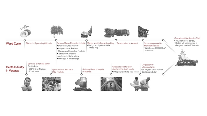
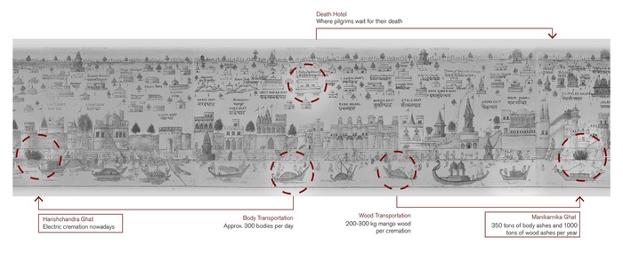
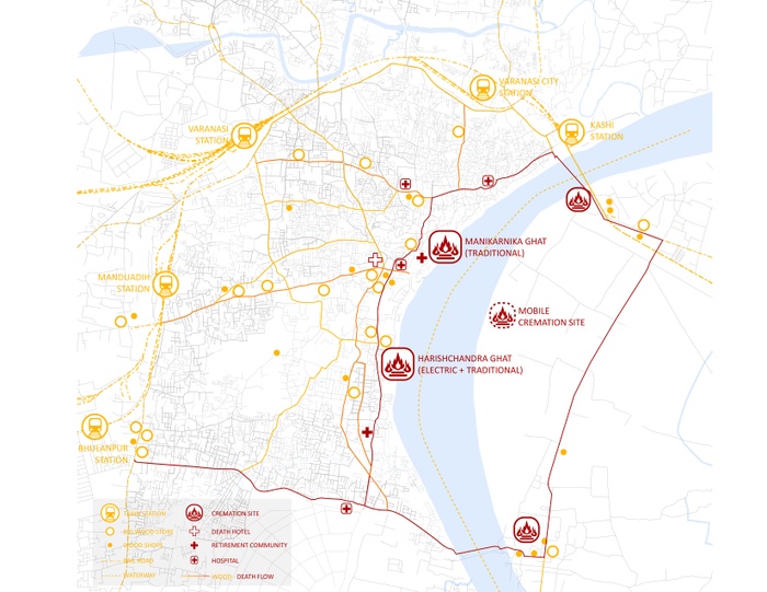
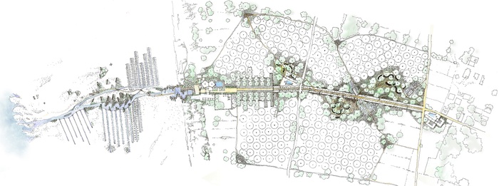
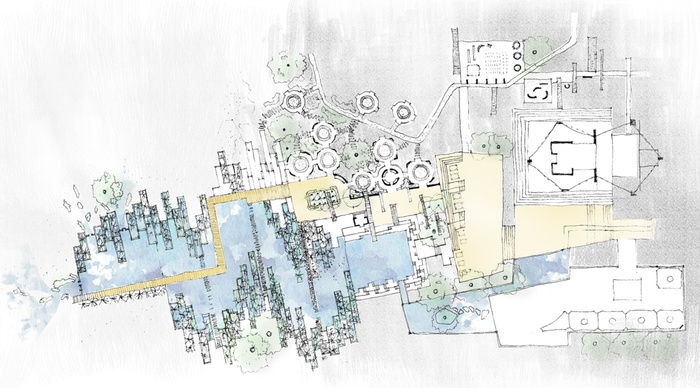
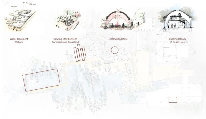
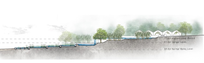
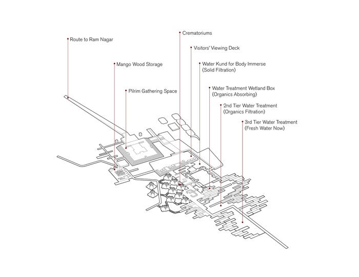
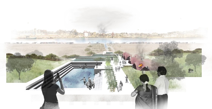
Life-Death Cycle:
Tzu-ying Chuang, Zenan (Jimmy) Guo, Yiqi Mei
Varanasi in Flux:
Ban Edilbi, Fatma Mhmood, Huanyu Chen, Xianyao Xia
High Ground + Low Ground:
Yanmin Bao, Yuqi Cui, Caroline Jeon, Yeonkyu Park
Forest of Bliss:
David Chonillo, Jorge Espinoza, Gigi Singh
Trans-Aggregation:
Donovan Dunkley, Saritza Martinez Rodriguez, Niomi Shah, Sofia Valdivieso
Four Commons:
Faisal Alzakari, Yue Hilary He, Ruilan Jia, Xiaohan Wang
IIT Student participants:
Dipanjan Nag, Nausad Ahmed, Anuradha Chakrabarti, Sunny Bansal, Thaju Zaman, Arpan Paul, Shivran Wattamwar, Vidhu Pandey, Aarsi Desai, Deepanjan Saha, Jyoti Kiran, Debanjan Kayal
Special Advisors:
Prof. Joy Sen, PhD, Prof. Arkopal K. Goswami, PhD, Prof. Bhargab Maitra (IIT), Students and Faculty of Banaras Hindu University
Curated and managed by:
Ban Edilbi, Jesse Hirakawa and Niharika Kannan